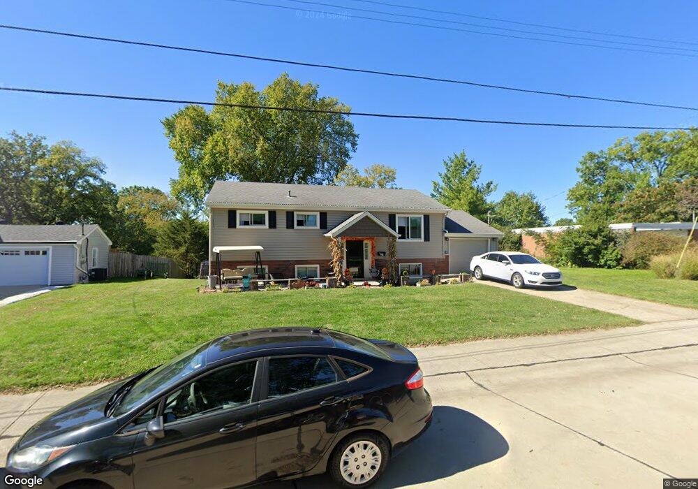
27 Sheridan Dr Alexandria, KY 41001
Estimated Value: $245,000 - $305,881
4
Beds
2
Baths
1,660
Sq Ft
$168/Sq Ft
Est. Value
About This Home
This home is located at 27 Sheridan Dr, Alexandria, KY 41001 and is currently estimated at $278,470, approximately $167 per square foot. 27 Sheridan Dr is a home located in Campbell County with nearby schools including Campbell Ridge Elementary School, Campbell County Middle School, and Campbell County High School.
Ownership History
Date
Name
Owned For
Owner Type
Purchase Details
Closed on
Oct 30, 2023
Sold by
Field Christopher R and Field Jamie
Bought by
Field Skyler and Field Ryan
Current Estimated Value
Home Financials for this Owner
Home Financials are based on the most recent Mortgage that was taken out on this home.
Original Mortgage
$257,744
Outstanding Balance
$252,965
Interest Rate
7.18%
Mortgage Type
FHA
Estimated Equity
$25,505
Purchase Details
Closed on
Jul 29, 2004
Sold by
Foutch Lois
Bought by
Field Christopher R and Field Jamie
Home Financials for this Owner
Home Financials are based on the most recent Mortgage that was taken out on this home.
Original Mortgage
$16,500
Interest Rate
6.22%
Mortgage Type
Credit Line Revolving
Create a Home Valuation Report for This Property
The Home Valuation Report is an in-depth analysis detailing your home's value as well as a comparison with similar homes in the area
Home Values in the Area
Average Home Value in this Area
Purchase History
| Date | Buyer | Sale Price | Title Company |
|---|---|---|---|
| Field Skyler | $260,000 | None Listed On Document | |
| Field Christopher R | $110,000 | Homeowners Title Agency Inc |
Source: Public Records
Mortgage History
| Date | Status | Borrower | Loan Amount |
|---|---|---|---|
| Open | Field Skyler | $257,744 | |
| Previous Owner | Field Christopher R | $16,500 | |
| Previous Owner | Field Christopher R | $88,000 |
Source: Public Records
Tax History Compared to Growth
Tax History
| Year | Tax Paid | Tax Assessment Tax Assessment Total Assessment is a certain percentage of the fair market value that is determined by local assessors to be the total taxable value of land and additions on the property. | Land | Improvement |
|---|---|---|---|---|
| 2024 | $3,141 | $260,000 | $40,000 | $220,000 |
| 2023 | $2,824 | $239,300 | $40,000 | $199,300 |
| 2022 | $1,732 | $137,900 | $30,000 | $107,900 |
| 2021 | $1,753 | $137,900 | $30,000 | $107,900 |
| 2020 | $1,778 | $137,900 | $30,000 | $107,900 |
| 2019 | $1,761 | $137,900 | $30,000 | $107,900 |
| 2018 | $1,627 | $126,100 | $18,200 | $107,900 |
| 2017 | $1,610 | $126,100 | $18,200 | $107,900 |
| 2016 | $1,541 | $126,100 | $0 | $0 |
| 2015 | $1,577 | $126,100 | $0 | $0 |
| 2014 | $1,521 | $126,100 | $0 | $0 |
Source: Public Records
Map
Nearby Homes
- 32 Bittersweet Dr
- 33 Shaw Dr
- 16 Shaw Dr
- 4 Fernwood Ct
- 113 Clearmeadow Dr
- 0 Persimmon Grove Pike
- 7908 Alexandria Pike
- 8208 W Main St
- 42 Ridgewood Dr
- 9027 Oak Ln
- 9039 Oak Ln
- 310 Washington St
- 4 Woodbury Ln
- 8 Driftwood Ct
- 921 Riffle Ridge Unit B
- 921 Riffle Ridge Unit A
- 889 Riffle Ridge Unit A
- 889 Riffle Ridge Unit B
- 921 Riffle Ridge Unit C
- 391 Aaron Dr