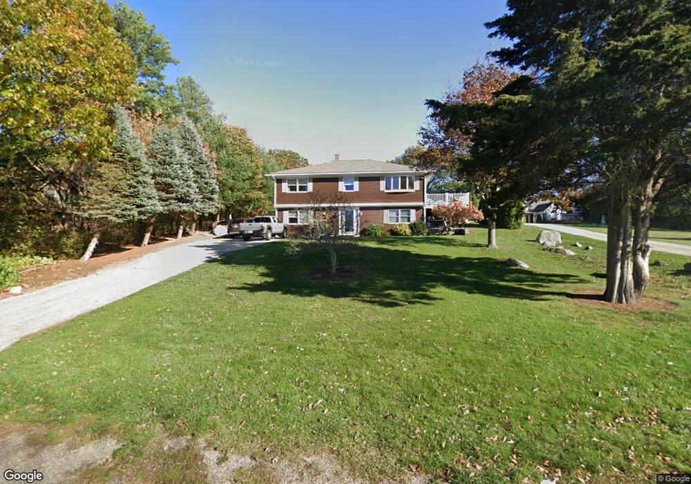
27 Thurston Point Rd Gloucester, MA 01930
Riverview NeighborhoodEstimated Value: $604,000 - $982,000
3
Beds
2
Baths
1,302
Sq Ft
$612/Sq Ft
Est. Value
About This Home
This home is located at 27 Thurston Point Rd, Gloucester, MA 01930 and is currently estimated at $796,958, approximately $612 per square foot. 27 Thurston Point Rd is a home located in Essex County with nearby schools including Beeman Memorial, Ralph B O'maley Middle School, and Gloucester High School.
Ownership History
Date
Name
Owned For
Owner Type
Purchase Details
Closed on
Jul 12, 1995
Sold by
Wadland Robert L and Wadland Beatrice F
Bought by
Lauarie Donald S and Laurie Deborah L
Current Estimated Value
Create a Home Valuation Report for This Property
The Home Valuation Report is an in-depth analysis detailing your home's value as well as a comparison with similar homes in the area
Home Values in the Area
Average Home Value in this Area
Purchase History
| Date | Buyer | Sale Price | Title Company |
|---|---|---|---|
| Lauarie Donald S | $108,000 | -- |
Source: Public Records
Mortgage History
| Date | Status | Borrower | Loan Amount |
|---|---|---|---|
| Open | Lauarie Donald S | $40,000 |
Source: Public Records
Tax History
| Year | Tax Paid | Tax Assessment Tax Assessment Total Assessment is a certain percentage of the fair market value that is determined by local assessors to be the total taxable value of land and additions on the property. | Land | Improvement |
|---|---|---|---|---|
| 2025 | $6,999 | $720,100 | $287,200 | $432,900 |
| 2024 | $7,188 | $738,700 | $273,500 | $465,200 |
| 2023 | $6,799 | $642,000 | $244,200 | $397,800 |
| 2022 | $6,310 | $537,900 | $207,500 | $330,400 |
| 2021 | $6,176 | $496,500 | $188,600 | $307,900 |
| 2020 | $5,941 | $481,800 | $188,600 | $293,200 |
| 2019 | $6,024 | $474,700 | $188,600 | $286,100 |
| 2018 | $5,719 | $442,300 | $188,600 | $253,700 |
| 2017 | $5,461 | $414,000 | $179,600 | $234,400 |
| 2016 | $5,383 | $395,500 | $180,100 | $215,400 |
| 2015 | $5,167 | $378,500 | $180,100 | $198,400 |
Source: Public Records
Map
Nearby Homes
- 13 Honeysuckle Rd
- 2 Breezy Point Rd
- 3 Deacon Farm Ln
- 31 Echo Ave
- 167 Atlantic St
- 178 Atlantic St
- 672 Washington St
- 226 Atlantic St
- 13 Mystic Ave
- 8 Mystic Ave
- 6 Monroe Ct
- 98 Maplewood Ave
- 5 Samoset Rd Unit B
- 145 Essex Ave Unit 402
- 9 Cleveland Place
- 12 Arthur St
- 15 Harvard St
- 24 Cobblestone Ln Unit 603
- 40 Sargent St
- 5 Lepage Ln
- 31 Thurston Point Rd
- 10 Mako Dr
- 25 Thurston Point Rd
- 35 Thurston Point Rd
- 23 Thurston Point Rd
- 23 Thurston Point Rd
- 21 Thurston Point Rd
- 36 Thurston Point Rd
- 38 Thurston Point Rd
- 47R 8 Mako Dr
- 13R Thurston Point Rd
- 34 Thurston Point Rd
- 8 Mako Dr
- 13 Thurston Point Rd
- 37 Thurston Point Rd
- 40 Thurston Point Rd
- 19 Thurston Point Rd
- 44 Thurston Point Rd
- 3 Mako Dr
- 4 Mako Dr
Your Personal Tour Guide
Ask me questions while you tour the home.