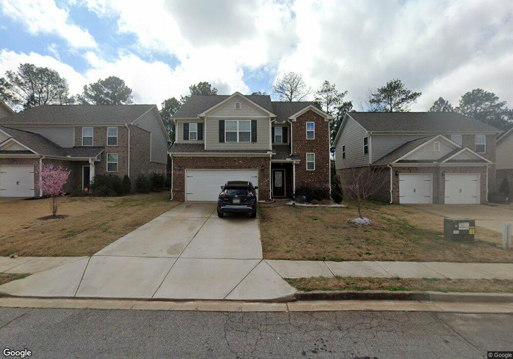
270 Higgins Rd Locust Grove, GA 30248
Estimated Value: $417,000 - $481,000
3
Beds
3
Baths
2,584
Sq Ft
$176/Sq Ft
Est. Value
About This Home
This home is located at 270 Higgins Rd, Locust Grove, GA 30248 and is currently estimated at $453,659, approximately $175 per square foot. 270 Higgins Rd is a home located in Henry County with nearby schools including Locust Grove Elementary School, Locust Grove Middle School, and Locust Grove High School.
Ownership History
Date
Name
Owned For
Owner Type
Purchase Details
Closed on
Aug 25, 2003
Sold by
Waldrop Bobby
Bought by
Waldrop Bobby
Current Estimated Value
Purchase Details
Closed on
Apr 17, 2003
Sold by
Cohran Michelle
Bought by
Waldrop Bobby
Create a Home Valuation Report for This Property
The Home Valuation Report is an in-depth analysis detailing your home's value as well as a comparison with similar homes in the area
Home Values in the Area
Average Home Value in this Area
Purchase History
| Date | Buyer | Sale Price | Title Company |
|---|---|---|---|
| Waldrop Bobby | -- | -- | |
| Waldrop Bobby | -- | -- |
Source: Public Records
Tax History Compared to Growth
Tax History
| Year | Tax Paid | Tax Assessment Tax Assessment Total Assessment is a certain percentage of the fair market value that is determined by local assessors to be the total taxable value of land and additions on the property. | Land | Improvement |
|---|---|---|---|---|
| 2025 | $5,711 | $211,240 | $19,720 | $191,520 |
| 2024 | $5,711 | $197,080 | $17,760 | $179,320 |
| 2023 | $5,426 | $190,400 | $17,120 | $173,280 |
| 2022 | $5,635 | $175,360 | $15,800 | $159,560 |
| 2021 | $1,496 | $149,840 | $13,560 | $136,280 |
| 2020 | $4,710 | $138,280 | $12,760 | $125,520 |
| 2019 | $2,537 | $131,360 | $12,120 | $119,240 |
| 2018 | $0 | $126,440 | $11,200 | $115,240 |
| 2016 | $4,104 | $114,280 | $9,880 | $104,400 |
| 2015 | -- | $113,160 | $9,480 | $103,680 |
| 2014 | -- | $78,600 | $11,360 | $67,240 |
Source: Public Records
Map
Nearby Homes
- 380 Higgins Rd
- 1064 Lear Dr
- 565 Carleton Place
- 231 Ferguson Ave
- 198 Aster Ave
- 194 Aster Ave
- 501 Vervain Dr
- 501 Kirkland Dr
- 190 Aster Ave
- 239 Ferguson Ave
- 269 Baumgard Way
- 188 Sophie Cir
- 191 Aster Ave
- 505 Kirkland Dr
- 505 Vervain Dr
- 608 Lobelia Dr
- 186 Aster Ave
- 182 Aster Ave
- 178 Aster Ave
- 150 Aster Ave
- 152 Al Jennah Blvd Unit 27
- 152 Al Jennah Blvd
- 150 Al Jennah Blvd Unit 26
- 150 Al Jennah Blvd
- 154 Al Jennah Blvd Unit 28
- 154 Al Jennah Blvd
- 154 Al Jennah Blvd
- 148 Al Jennah Blvd Unit 25
- 148 Al Jennah Blvd
- 156 Al Jennah Blvd Unit 29
- 156 Al Jennah Blvd
- 146 Al Jennah Blvd Unit 24
- 146 Al Jennah Blvd
- 158 Al Jennah Blvd Unit 30
- 158 Al Jennah Blvd
- 144 Al Jennah Blvd Unit 23
- 144 Al Jennah Blvd
- 142 Al Jennah Blvd Unit 22
- 142 Al Jennah Blvd
- 161 Al Jennah Blvd Unit 65