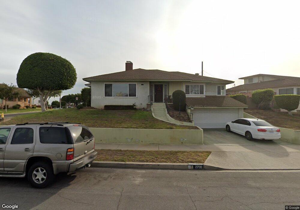
2700 W 102nd St Inglewood, CA 90303
South Inglewood NeighborhoodEstimated Value: $928,368 - $1,168,000
3
Beds
2
Baths
2,159
Sq Ft
$465/Sq Ft
Est. Value
About This Home
This home is located at 2700 W 102nd St, Inglewood, CA 90303 and is currently estimated at $1,004,592, approximately $465 per square foot. 2700 W 102nd St is a home located in Los Angeles County with nearby schools including Woodworth - Monroe TK-8 Academy, Monroe (Albert F.) Middle School, and Morningside High School.
Ownership History
Date
Name
Owned For
Owner Type
Purchase Details
Closed on
Jul 24, 1999
Sold by
Porter Charlie E and The Charles E Porter Sr Living
Bought by
Sapp Kevin and Thomas Sapp Donna D
Current Estimated Value
Home Financials for this Owner
Home Financials are based on the most recent Mortgage that was taken out on this home.
Original Mortgage
$182,400
Interest Rate
7.89%
Purchase Details
Closed on
Nov 3, 1998
Sold by
Porter Charlie E and Porter Charlie E
Bought by
Porter Charlie E and The Charlie E Porter Sr Living
Create a Home Valuation Report for This Property
The Home Valuation Report is an in-depth analysis detailing your home's value as well as a comparison with similar homes in the area
Home Values in the Area
Average Home Value in this Area
Purchase History
| Date | Buyer | Sale Price | Title Company |
|---|---|---|---|
| Sapp Kevin | $228,000 | Provident Title Company | |
| Porter Charlie E | -- | -- |
Source: Public Records
Mortgage History
| Date | Status | Borrower | Loan Amount |
|---|---|---|---|
| Previous Owner | Sapp Kevin | $182,400 | |
| Closed | Sapp Kevin | $22,800 |
Source: Public Records
Tax History Compared to Growth
Tax History
| Year | Tax Paid | Tax Assessment Tax Assessment Total Assessment is a certain percentage of the fair market value that is determined by local assessors to be the total taxable value of land and additions on the property. | Land | Improvement |
|---|---|---|---|---|
| 2025 | $4,796 | $350,404 | $251,283 | $99,121 |
| 2024 | $4,796 | $343,534 | $246,356 | $97,178 |
| 2023 | $4,749 | $336,799 | $241,526 | $95,273 |
| 2022 | $4,829 | $330,196 | $236,791 | $93,405 |
| 2021 | $4,777 | $323,723 | $232,149 | $91,574 |
| 2019 | $4,500 | $314,123 | $225,264 | $88,859 |
| 2018 | $4,440 | $307,965 | $220,848 | $87,117 |
| 2016 | $4,196 | $296,008 | $212,273 | $83,735 |
| 2015 | $4,158 | $291,563 | $209,085 | $82,478 |
| 2014 | $4,155 | $285,853 | $204,990 | $80,863 |
Source: Public Records
Map
Nearby Homes
- 10225 S 7th Ave
- 10233 S 5th Ave
- 10401 S 7th Ave
- 2417 W 101st St
- 3209 Bartdon Ave
- 10525 S 8th Ave
- 10525 S 5th Ave
- 10404 S 3rd Ave
- 9813 S 3rd Ave
- 9710 S 8th Ave
- 10519 S 3rd Ave
- 10607 Crenshaw Blvd
- 10421 S 1st Ave
- 10619 Crenshaw Blvd
- 10625 Crenshaw Blvd
- 10401 S Van Ness Ave
- 10725 S 8th Ave
- 9606 S 4th Ave
- 2709 W 109th St
- 9806 S Van Ness Ave
- 10213 S 6th Ave
- 2704 W 102nd St
- 10212 S 6th Ave
- 2709 W 102nd St
- 10217 S 6th Ave
- 2708 W 102nd St
- 2713 W 102nd St
- 2705 W 102nd St
- 2901 W 102nd St
- 10216 S 6th Ave
- 2701 W 102nd St
- 10212 S 7th Ave
- 10221 S 6th Ave
- 2620 W 102nd St
- 10216 S 7th Ave
- 2716 W 101st St
- 2712 W 101st St
- 10220 S 7th Ave
- 2720 W 101st St
- 2905 W 102nd St