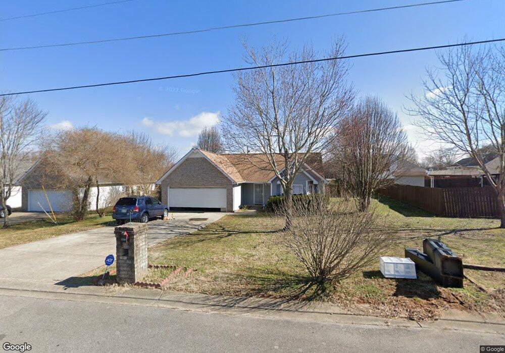
2702 Pickards Point La Vergne, TN 37086
Estimated Value: $305,499 - $362,000
--
Bed
2
Baths
1,344
Sq Ft
$254/Sq Ft
Est. Value
About This Home
This home is located at 2702 Pickards Point, La Vergne, TN 37086 and is currently estimated at $341,875, approximately $254 per square foot. 2702 Pickards Point is a home located in Rutherford County with nearby schools including Lavergne Primary School, Roy L. Waldron Elementary School, and La Vergne Middle School.
Ownership History
Date
Name
Owned For
Owner Type
Purchase Details
Closed on
Apr 28, 2005
Sold by
Odds Marvo C
Bought by
Mohammed Al-Shimary and Mohammed Shimary Mohammed
Current Estimated Value
Home Financials for this Owner
Home Financials are based on the most recent Mortgage that was taken out on this home.
Original Mortgage
$117,000
Outstanding Balance
$61,159
Interest Rate
5.98%
Mortgage Type
Purchase Money Mortgage
Estimated Equity
$280,716
Purchase Details
Closed on
Aug 8, 2001
Sold by
Madison Square Llc
Bought by
St James Homes
Home Financials for this Owner
Home Financials are based on the most recent Mortgage that was taken out on this home.
Original Mortgage
$115,158
Interest Rate
7.19%
Create a Home Valuation Report for This Property
The Home Valuation Report is an in-depth analysis detailing your home's value as well as a comparison with similar homes in the area
Home Values in the Area
Average Home Value in this Area
Purchase History
| Date | Buyer | Sale Price | Title Company |
|---|---|---|---|
| Mohammed Al-Shimary | $130,000 | -- | |
| St James Homes | -- | -- | |
| Odds Marvo C | $112,900 | -- |
Source: Public Records
Mortgage History
| Date | Status | Borrower | Loan Amount |
|---|---|---|---|
| Open | Odds Marvo C | $117,000 | |
| Previous Owner | Odds Marvo C | $115,158 |
Source: Public Records
Tax History Compared to Growth
Tax History
| Year | Tax Paid | Tax Assessment Tax Assessment Total Assessment is a certain percentage of the fair market value that is determined by local assessors to be the total taxable value of land and additions on the property. | Land | Improvement |
|---|---|---|---|---|
| 2025 | $1,598 | $66,250 | $13,750 | $52,500 |
| 2024 | $1,598 | $66,250 | $13,750 | $52,500 |
| 2023 | $1,243 | $66,250 | $13,750 | $52,500 |
| 2022 | $1,071 | $66,250 | $13,750 | $52,500 |
| 2021 | $959 | $43,200 | $8,750 | $34,450 |
| 2020 | $959 | $43,200 | $8,750 | $34,450 |
| 2019 | $959 | $43,200 | $8,750 | $34,450 |
| 2018 | $1,214 | $43,200 | $0 | $0 |
| 2017 | $1,146 | $31,575 | $0 | $0 |
| 2016 | $1,146 | $31,575 | $0 | $0 |
| 2015 | $1,154 | $31,575 | $0 | $0 |
| 2014 | $785 | $31,575 | $0 | $0 |
| 2013 | -- | $32,050 | $0 | $0 |
Source: Public Records
Map
Nearby Homes
- 403 Independence Ct
- 613 Sycamore Ln
- 6724 Birchbrook Dr
- 1119 Moss Trail
- 7511 Cash Crossing Ct
- 4237 Miranda Place
- 5352 Sunnyvale Dr
- 7543 Cash Crossing Ct
- 7013 Alon Babayan Arch
- 178 Ramsden Ave
- 2015 Keaton Dr
- 7022 Alon Babayan Arch
- 6416 Wildgrove Dr
- 306 Cotton Ct
- 164 Ramsden Ave
- 8007 Mickey Katz Cir
- 102 Freeboard Alley
- 930 Patty Cove
- 5152 Brookstone Ct
- 144 Ramsden Ave
- 2704 Pickards Point
- 2607 Weatherford St
- 2805 General Maney Ct
- 2803 General Maney Ct
- 2807 General Maney Ct
- 2706 Pickards Point
- 2605 Weatherford St
- 2703 Pickards Point
- 2609 Weatherford St
- 2809 General Maney Ct
- 2705 Pickards Point
- 2708 Pickards Point
- 2603 Weatherford St
- 2608 Weatherford St
- 2606 Weatherford St
- 2811 General Maney Ct
- 2610 Weatherford St
- 2604 Weatherford St
- 2804 General Maney Ct
- 2802 General Maney Ct