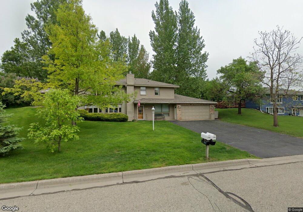
2704 Shawnee Ln Burnsville, MN 55337
Estimated Value: $374,000 - $419,000
4
Beds
2
Baths
1,092
Sq Ft
$354/Sq Ft
Est. Value
About This Home
This home is located at 2704 Shawnee Ln, Burnsville, MN 55337 and is currently estimated at $387,077, approximately $354 per square foot. 2704 Shawnee Ln is a home located in Dakota County with nearby schools including Edward Neill Elementary School, Joseph Nicollet Middle School, and Burnsville High School.
Ownership History
Date
Name
Owned For
Owner Type
Purchase Details
Closed on
Feb 9, 2001
Sold by
North Country Holdings Lcc
Bought by
Haedtke James E and Haedtke Nancy E
Current Estimated Value
Purchase Details
Closed on
Oct 19, 2000
Sold by
Kahiapo William V and Kahiapo Caralynn K
Bought by
North Country Holdings Llc
Purchase Details
Closed on
Jan 5, 1996
Sold by
Bank Of America Natl Trust & Svgs Assn
Bought by
Kahiapo William and Kahiapo Coralynn K
Create a Home Valuation Report for This Property
The Home Valuation Report is an in-depth analysis detailing your home's value as well as a comparison with similar homes in the area
Home Values in the Area
Average Home Value in this Area
Purchase History
| Date | Buyer | Sale Price | Title Company |
|---|---|---|---|
| Haedtke James E | $167,500 | -- | |
| North Country Holdings Llc | $107,000 | -- | |
| Kahiapo William | $88,010 | -- |
Source: Public Records
Tax History Compared to Growth
Tax History
| Year | Tax Paid | Tax Assessment Tax Assessment Total Assessment is a certain percentage of the fair market value that is determined by local assessors to be the total taxable value of land and additions on the property. | Land | Improvement |
|---|---|---|---|---|
| 2024 | $3,224 | $312,000 | $83,800 | $228,200 |
| 2023 | $3,224 | $313,400 | $83,900 | $229,500 |
| 2022 | $2,758 | $314,600 | $83,700 | $230,900 |
| 2021 | $2,876 | $266,900 | $72,800 | $194,100 |
| 2020 | $2,806 | $253,600 | $69,300 | $184,300 |
| 2019 | $2,838 | $239,100 | $66,000 | $173,100 |
| 2018 | $2,741 | $230,300 | $62,900 | $167,400 |
| 2017 | $2,569 | $216,400 | $59,900 | $156,500 |
| 2016 | $2,579 | $200,500 | $57,100 | $143,400 |
| 2015 | $2,430 | $173,784 | $49,730 | $124,054 |
| 2014 | -- | $169,424 | $48,611 | $120,813 |
| 2013 | -- | $154,709 | $43,751 | $110,958 |
Source: Public Records
Map
Nearby Homes
- 2704 W 135th St
- 13817 Thomas Ave S
- 13840 York Ave S
- 13812 Sunset Lake Dr
- 2408 Friendship Ln
- 2104 W 140th St
- 1905 W 140th St
- 13208 Upton Ave S
- 13717 W Preserve Blvd
- 13303 Morgan Ave S
- 1701 W 138th St
- 1725 W 140th St
- 4008 W 137th St
- 13100 Thomas Ave S
- 2729 Terrace Dr
- 1200 W 136th St
- 13036 Judicial Rd
- 1009 Knob Hill Rd
- 2708 Williams Dr
- 2909 Sunnyside Cir
- 2708 Shawnee Ln
- 2700 Shawnee Ln
- 13624 Upton Ave S
- 13622 Upton Ave S
- 13626 Upton Ave S
- 13637 Vincent Ave S
- 2705 Shawnee Ln
- 13701 Vincent Ave S
- 2701 Shawnee Ln
- 13620 Upton Ave S
- 13705 Vincent Ave S
- 13629 Vincent Ave S
- 13700 Vincent Ave S
- 13636 Vincent Ave S
- 13618 Upton Ave S
- 13616 Upton Ave S
- 13614 Upton Ave S
- 13704 Vincent Ave S
- 13625 Vincent Ave S
- 13632 Vincent Ave S