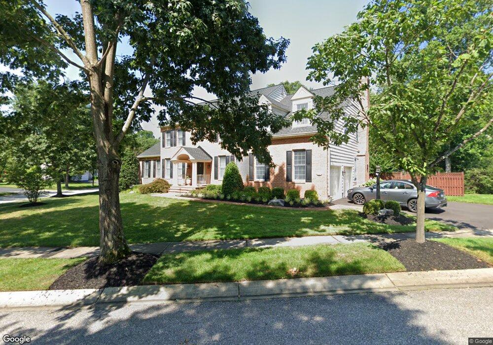
2704 Windswept Ln Annapolis, MD 21401
Parole NeighborhoodEstimated Value: $905,341 - $1,061,000
Studio
4
Baths
3,329
Sq Ft
$300/Sq Ft
Est. Value
About This Home
This home is located at 2704 Windswept Ln, Annapolis, MD 21401 and is currently estimated at $997,835, approximately $299 per square foot. 2704 Windswept Ln is a home located in Anne Arundel County with nearby schools including Rolling Knolls Elementary School, Wiley H. Bates Middle School, and Annapolis High School.
Ownership History
Date
Name
Owned For
Owner Type
Purchase Details
Closed on
Aug 18, 2004
Sold by
Miller Kenneth I
Bought by
Ryan John E and Ryan Brenda K
Current Estimated Value
Purchase Details
Closed on
Aug 16, 2004
Sold by
Miller Kenneth I
Bought by
Ryan John E and Ryan Brenda K
Purchase Details
Closed on
May 14, 1997
Sold by
Riva South Limited Partnership
Bought by
Miller Kenneth I and Miller Kristi
Create a Home Valuation Report for This Property
The Home Valuation Report is an in-depth analysis detailing your home's value as well as a comparison with similar homes in the area
Home Values in the Area
Average Home Value in this Area
Purchase History
| Date | Buyer | Sale Price | Title Company |
|---|---|---|---|
| Ryan John E | $725,000 | -- | |
| Ryan John E | $725,000 | -- | |
| Miller Kenneth I | $386,816 | -- |
Source: Public Records
Mortgage History
| Date | Status | Borrower | Loan Amount |
|---|---|---|---|
| Closed | Ryan John E | -- |
Source: Public Records
Tax History
| Year | Tax Paid | Tax Assessment Tax Assessment Total Assessment is a certain percentage of the fair market value that is determined by local assessors to be the total taxable value of land and additions on the property. | Land | Improvement |
|---|---|---|---|---|
| 2025 | $7,813 | $767,267 | -- | -- |
| 2024 | $7,813 | $708,633 | $0 | $0 |
| 2023 | $7,572 | $650,000 | $215,100 | $434,900 |
| 2022 | $7,223 | $650,000 | $215,100 | $434,900 |
| 2020 | $7,039 | $672,600 | $190,100 | $482,500 |
| 2019 | $6,930 | $672,600 | $190,100 | $482,500 |
| 2018 | $6,820 | $672,600 | $190,100 | $482,500 |
| 2017 | $6,548 | $684,800 | $0 | $0 |
| 2016 | -- | $681,967 | $0 | $0 |
| 2015 | -- | $679,133 | $0 | $0 |
| 2014 | -- | $676,300 | $0 | $0 |
Source: Public Records
Map
Nearby Homes
- 301 Unity Ln
- 2707 Judson Place
- 2707 Summerview Way Unit 101
- 2702 Summerview Way Unit 103
- 2729 Poplar Ln
- 110 Marquise Ln
- 2738 Gingerview Ln
- 2733 Gingerview Ln
- 371 Carriage Park Way
- 2977 Southaven Dr
- 2702 Gingerview Ln
- 2942 Southaven Dr
- 2941 Southaven Dr
- 3029 Solstice Ln
- 2725 Cabernet Ln
- 2913 Southaven Dr
- 105 Wallace Manor Rd
- 905 Scupper Ct
- 232 Cardamon Dr
- 807 Eastern Point Rd
- 310 Broad Creek Dr
- 2702 Windswept Ln
- 2703 Windswept Ln
- 2700 Windswept Ln
- 312 Broad Creek Dr
- 2800 Durmont Ct
- 314 Broad Creek Dr
- 311 Broad Creek Dr
- 2801 Durmont Ct
- 2701 Windswept Ln
- 304 Broad Creek Dr
- 2804 Durmont Ct
- 316 Broad Creek Dr
- 2803 Durmont Ct
- 313 Broad Creek Dr
- 301 Broad Creek Dr
- 302 Broad Creek Dr
- 2805 Durmont Ct
- 2808 Durmont Ct
- 318 Broad Creek Dr
Your Personal Tour Guide
Ask me questions while you tour the home.