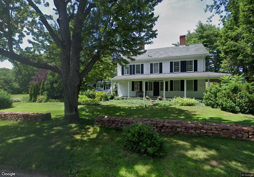
271 Duncaster Rd Bloomfield, CT 06002
Estimated Value: $678,089 - $868,000
5
Beds
4
Baths
4,185
Sq Ft
$187/Sq Ft
Est. Value
About This Home
This home is located at 271 Duncaster Rd, Bloomfield, CT 06002 and is currently estimated at $782,772, approximately $187 per square foot. 271 Duncaster Rd is a home located in Hartford County with nearby schools including Laurel School, Metacomet School, and Carmen Arace Intermediate School.
Ownership History
Date
Name
Owned For
Owner Type
Purchase Details
Closed on
Sep 1, 1995
Sold by
Merritt Robert and Merritt Priscilla
Bought by
Hess Aaron and Hess Martha
Current Estimated Value
Home Financials for this Owner
Home Financials are based on the most recent Mortgage that was taken out on this home.
Original Mortgage
$100,000
Interest Rate
7.05%
Mortgage Type
Purchase Money Mortgage
Create a Home Valuation Report for This Property
The Home Valuation Report is an in-depth analysis detailing your home's value as well as a comparison with similar homes in the area
Home Values in the Area
Average Home Value in this Area
Purchase History
| Date | Buyer | Sale Price | Title Company |
|---|---|---|---|
| Hess Aaron | $275,000 | -- | |
| Hess Aaron | $275,000 | -- |
Source: Public Records
Mortgage History
| Date | Status | Borrower | Loan Amount |
|---|---|---|---|
| Closed | Hess Aaron | $100,000 |
Source: Public Records
Tax History
| Year | Tax Paid | Tax Assessment Tax Assessment Total Assessment is a certain percentage of the fair market value that is determined by local assessors to be the total taxable value of land and additions on the property. | Land | Improvement |
|---|---|---|---|---|
| 2025 | $16,958 | $452,200 | $83,790 | $368,410 |
| 2024 | $13,360 | $340,480 | $67,830 | $272,650 |
| 2023 | $13,119 | $340,480 | $67,830 | $272,650 |
| 2022 | $12,267 | $340,480 | $67,830 | $272,650 |
| 2021 | $12,540 | $340,480 | $67,830 | $272,650 |
| 2020 | $12,346 | $340,480 | $67,830 | $272,650 |
| 2019 | $13,038 | $337,260 | $67,830 | $269,430 |
| 2018 | $12,852 | $332,780 | $67,060 | $265,720 |
| 2017 | $12,832 | $332,780 | $67,060 | $265,720 |
| 2016 | $12,529 | $332,780 | $67,060 | $265,720 |
| 2015 | $12,296 | $332,780 | $67,060 | $265,720 |
| 2014 | $12,181 | $340,830 | $50,540 | $290,290 |
Source: Public Records
Map
Nearby Homes
- 68 Tariffville Rd
- 74 Tariffville Rd
- 50 Habitat Ln
- 4 Lewis St
- 823 Stone Rd
- 24 Hunting Ridge Dr
- 322 Tunxis Ave
- 16 Hilltop Rd
- 14 Main Street Extension
- 22 Old Hartford Ave Unit 22
- 406 Tunxis Ave
- 16 Seymour Rd Unit 21C
- 16 Seymour Rd Unit 2H
- 39 Loren Cir
- 49 Seymour Rd
- 59 Cambridge Ct
- 999 Stone Rd
- 7 Glen Hollow
- 234 Woodland Ave
- 31 Oxford Ct
- 272 Duncaster Rd
- 267 Duncaster Rd
- 270 Duncaster Rd
- 24 Tariffville Rd
- 11 Tariffville Rd
- 261 Duncaster Rd
- 264 Duncaster Rd
- 263 Duncaster Rd
- 263 Duncaster Rd
- 27 Tariffville Rd
- 259 Duncaster Rd
- 3 Scotland Rd
- 2 Scotland Rd
- 445 Tunxis Ave
- 255 Duncaster Rd
- 5 Scotland Rd
- 31 Tariffville Rd
- 443 Tunxis Ave
- 4 Scotland Rd
- 8 Beman Ln
Your Personal Tour Guide
Ask me questions while you tour the home.