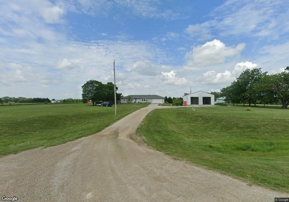
271 E 1250 Rd Baldwin City, KS 66006
Estimated Value: $386,000 - $491,403
3
Beds
2
Baths
1,842
Sq Ft
$236/Sq Ft
Est. Value
About This Home
This home is located at 271 E 1250 Rd, Baldwin City, KS 66006 and is currently estimated at $434,801, approximately $236 per square foot. 271 E 1250 Rd is a home located in Douglas County with nearby schools including Baldwin Elementary Primary Center, Baldwin Elementary Intermediate Center, and Baldwin Junior High School.
Ownership History
Date
Name
Owned For
Owner Type
Purchase Details
Closed on
May 5, 2010
Sold by
Dlj Mortgage Capital Inc
Bought by
Hoobler Chad
Current Estimated Value
Home Financials for this Owner
Home Financials are based on the most recent Mortgage that was taken out on this home.
Original Mortgage
$143,000
Interest Rate
5.14%
Mortgage Type
Construction
Create a Home Valuation Report for This Property
The Home Valuation Report is an in-depth analysis detailing your home's value as well as a comparison with similar homes in the area
Home Values in the Area
Average Home Value in this Area
Purchase History
| Date | Buyer | Sale Price | Title Company |
|---|---|---|---|
| Hoobler Chad | -- | Insight Title Co Llc |
Source: Public Records
Mortgage History
| Date | Status | Borrower | Loan Amount |
|---|---|---|---|
| Closed | Hoobler Chad | $143,000 |
Source: Public Records
Tax History Compared to Growth
Tax History
| Year | Tax Paid | Tax Assessment Tax Assessment Total Assessment is a certain percentage of the fair market value that is determined by local assessors to be the total taxable value of land and additions on the property. | Land | Improvement |
|---|---|---|---|---|
| 2025 | $4,416 | $45,887 | $13,467 | $32,420 |
| 2024 | $4,416 | $38,825 | $13,237 | $25,588 |
| 2023 | $4,230 | $35,719 | $9,410 | $26,309 |
| 2022 | $4,150 | $33,787 | $9,410 | $24,377 |
| 2021 | $3,738 | $29,808 | $8,895 | $20,913 |
| 2020 | $3,498 | $27,816 | $8,895 | $18,921 |
| 2019 | $3,333 | $26,491 | $9,331 | $17,160 |
| 2018 | $3,339 | $26,392 | $8,113 | $18,279 |
| 2017 | $2,911 | $22,466 | $8,113 | $14,353 |
| 2016 | $3,025 | $23,643 | $5,986 | $17,657 |
| 2015 | -- | $24,024 | $5,986 | $18,038 |
| 2014 | -- | $23,518 | $5,986 | $17,532 |
Source: Public Records
Map
Nearby Homes
- 1140 N 100th Rd
- 137 E 1400 Rd
- 137 E 1400th Rd
- 1077 N 150 Rd
- 1447 & 1449 N 150 Rd
- Lot 10 Block 3 Bluestem Cir
- Lot 24 Wagon Rd
- Lot 3 Block 3 Bluestem Cir
- Lot 26 Wagon Rd
- 1560 N 100 Rd Unit Parcel 2
- Lot 35 Settler Ln
- Lot 8 Trail View Cir
- 10.01 Acres M/L N 800 Rd
- 1580 N 100 Rd Unit Parcel 3
- 1246 & Parcel 4 N 1 Rd
- Lot 23 Wagon Rd
- Lot 2 Block 3 Bluestem Cir
- RDP2 N 400 Rd
- 124 E 1550 Rd
- Lot 1 Block 1 Bluestem
- 271 E 1250th Rd
- 261 E 1250th Rd
- Lot4 56 59 Junction N A
- Lot2 56 59 Junction N A
- Lot1 56 59 Junction N A
- Lot 4 56 59 Junction N A
- Lot 3 56 59 Junction N A
- Lot 2 56 59 Junction N A
- Lot 1 56 59 Junction N A
- E1260 56 59 Junction N A
- 259 E 1250th Rd
- 1250 N 300th Rd
- Land 59 Hwy
- 1268 N 222nd Rd
- 0 E 1260 Rd
- 262 E 1260 Rd
- 227 E 1250th Rd
- 227 E 1250th Rd
- 227 E 1250th Rd
- 227 E 1250th Rd