
Seller's Agent in 2026
Hussein Garcia
Keller Williams Realty Downtown LLC
(303) 908-2788
215 Total Sales


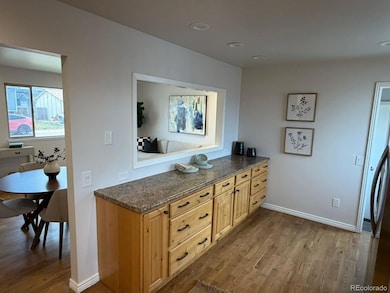


Welcome to 271 Elm Street In Bennett- an exceptional opportunity own a beautifully refreshed home in a prime, accessible location. This property has been thoughtfully updated to deliver both immediate comfort and long term value, making it ideal for owner occupants and investors alike. The interior has been freshly painted throughout, creating a clean, modern feel that pairs perfectly with the refinished hardwood floors. These original hardwoods add timeless character while showcasing the quality of the home. Brand New carpet enhances the bedrooms and lower level spaces, offering warmth and comfort where it matters most. Updated electrical fixtures throughout the home provide a crisp, contemporary touch and peace of mind for today's buyer. The main level offers a functional and inviting layout with great flow, allowing for comfortable daily living and easy entertaining. Natural light fills the living spaces, highlighting the recent improvements and creating an open, welcoming atmosphere. One of the standout features is the full finished basement, providing valuable additional square footage. Whether uses as a second living area, home office, recreation space, guest quarters, or workout room, the basement offers flexibility rarely found a this price point. This extra space significantly enhances both livability and rental potential. Situated in the heart of Bennett, this home benefits from a convenient location with easy access to schools, parks, local amenities, and major commuting routes, while still maintaining a small town feel. The property is being listed aggressively for its condition and location, making it a rare value in today's market. Turn-key, refreshed, and priced to move, this property is a must see!
Last Agent to Sell the Property
Keller Williams Realty Downtown LLC Brokerage Email: hussein@platinumteamre.com,303-908-2788 License #100018797 Listed on: 12/09/2025
| Date | Type | Sale Price | Title Company |
|---|---|---|---|
| Warranty Deed | $370,000 | Chicago Title | |
| Special Warranty Deed | $222,400 | Ct (Chicago Title) | |
| Warranty Deed | $162,000 | Heritage Title | |
| Special Warranty Deed | $110,000 | Heritage Title | |
| Deed In Lieu Of Foreclosure | $171,652 | None Available |
| Date | Status | Loan Amount | Loan Type |
|---|---|---|---|
| Open | $14,256 | FHA | |
| Open | $356,410 | FHA | |
| Previous Owner | $165,306 | New Conventional | |
| Previous Owner | $124,365 | FHA |
| Date | Event | Price | List to Sale | Price per Sq Ft |
|---|---|---|---|---|
| 02/13/2026 02/13/26 | Sold | $370,000 | +1.4% | $214 / Sq Ft |
| 12/09/2025 12/09/25 | For Sale | $365,000 | -- | $211 / Sq Ft |
| Year | Tax Paid | Tax Assessment Tax Assessment Total Assessment is a certain percentage of the fair market value that is determined by local assessors to be the total taxable value of land and additions on the property. | Land | Improvement |
|---|---|---|---|---|
| 2025 | $1,944 | $24,410 | $4,080 | $20,330 |
| 2024 | $1,944 | $22,440 | $3,750 | $18,690 |
| 2023 | $1,956 | $26,580 | $4,460 | $22,120 |
| 2022 | $1,834 | $21,280 | $4,590 | $16,690 |
| 2021 | $1,871 | $21,280 | $4,590 | $16,690 |
| 2020 | $1,669 | $19,810 | $4,720 | $15,090 |
| 2019 | $1,714 | $19,810 | $4,720 | $15,090 |
| 2018 | $1,711 | $17,980 | $2,300 | $15,680 |
| 2017 | $1,726 | $17,980 | $2,300 | $15,680 |
| 2016 | $1,040 | $11,220 | $2,550 | $8,670 |
| 2015 | $1,035 | $11,220 | $2,550 | $8,670 |
| 2014 | $890 | $9,530 | $2,390 | $7,140 |
Seller's Agent in 2026
Hussein Garcia
Keller Williams Realty Downtown LLC
(303) 908-2788
215 Total Sales
Buyer's Agent in 2026
Brianna Anthony
KM Luxury Homes
(720) 397-9371
6 Total Sales
Source: REcolorado®
MLS Number: 8951228
APN: 1815-27-3-33-013
Disclaimer: Certain information contained herein is derived from information provided by parties other than Homes.com. All information provided is deemed reliable, but is not guaranteed to be accurate and should be independently verified.
![]() Based on information submitted to the MLS GRID. All data is obtained from various sources and may not have been verified by broker or MLS GRID. Supplied Open House Information is subject to change without notice. All information should be independently reviewed and verified for accuracy. Properties may or may not be listed by the office/agent presenting the information. Some IDX listings have been excluded from this website. The content relating to real estate for sale in this Web site comes in part from the Internet Data eXchange (“IDX”) program of METROLIST, INC., DBA RECOLORADO®. Real estate listings held by brokers other than Ten-X are marked with the IDX Logo. This information is being provided for the consumers’ personal, non-commercial use and may not be used for any other purpose. All information is subject to change and should be independently verified.
Based on information submitted to the MLS GRID. All data is obtained from various sources and may not have been verified by broker or MLS GRID. Supplied Open House Information is subject to change without notice. All information should be independently reviewed and verified for accuracy. Properties may or may not be listed by the office/agent presenting the information. Some IDX listings have been excluded from this website. The content relating to real estate for sale in this Web site comes in part from the Internet Data eXchange (“IDX”) program of METROLIST, INC., DBA RECOLORADO®. Real estate listings held by brokers other than Ten-X are marked with the IDX Logo. This information is being provided for the consumers’ personal, non-commercial use and may not be used for any other purpose. All information is subject to change and should be independently verified.
This publication is designed to provide information with regard to the subject matter covered. It is displayed with the understanding that the publisher and authors are not engaged in rendering real estate, legal, accounting, tax, or other professional services and that the publisher and authors are not offering such advice in this publication. If real estate, legal, or other expert assistance is required, the services of a competent, professional person should be sought.
The information contained in this publication is subject to change without notice. METROLIST, INC., DBA RECOLORADO MAKES NO WARRANTY OF ANY KIND WITH REGARD TO THIS MATERIAL, INCLUDING, BUT NOT LIMITED TO, THE IMPLIED WARRANTIES OF MERCHANTABILITY AND FITNESS FOR A PARTICULAR PURPOSE. METROLIST, INC., DBA RECOLORADO SHALL NOT BE LIABLE FOR ERRORS CONTAINED HEREIN OR FOR ANY DAMAGES IN CONNECTION WITH THE FURNISHING, PERFORMANCE, OR USE OF THIS MATERIAL.
PUBLISHER’S NOTICE: All real estate advertised herein is subject to the Federal Fair Housing Act and the Colorado Fair Housing Act, which Acts make it illegal to make or publish any advertisement that indicates any preference, limitation, or discrimination based on race, color, religion, sex, handicap, familial status, or national origin.
METROLIST, INC., DBA RECOLORADO will not knowingly accept any advertising for real estate that is in violation of the law. All persons are hereby informed that all dwellings advertised are available on an equal opportunity basis.
© 2026 METROLIST, INC., DBA RECOLORADO® – All Rights Reserved. 6455 S. Yosemite St., Suite 500 Greenwood Village, CO 80111 USA
ALL RIGHTS RESERVED WORLDWIDE. No part of this publication may be reproduced, adapted, translated, stored in a retrieval system or transmitted in any form or by any means, electronic, mechanical, photocopying, recording, or otherwise, without the prior written permission of the publisher. The information contained herein including but not limited to all text, photographs, digital images, virtual tours, may be seeded and monitored for protection and tracking.
Based on information submitted to the MLS GRID
Ask me questions while you tour the home.