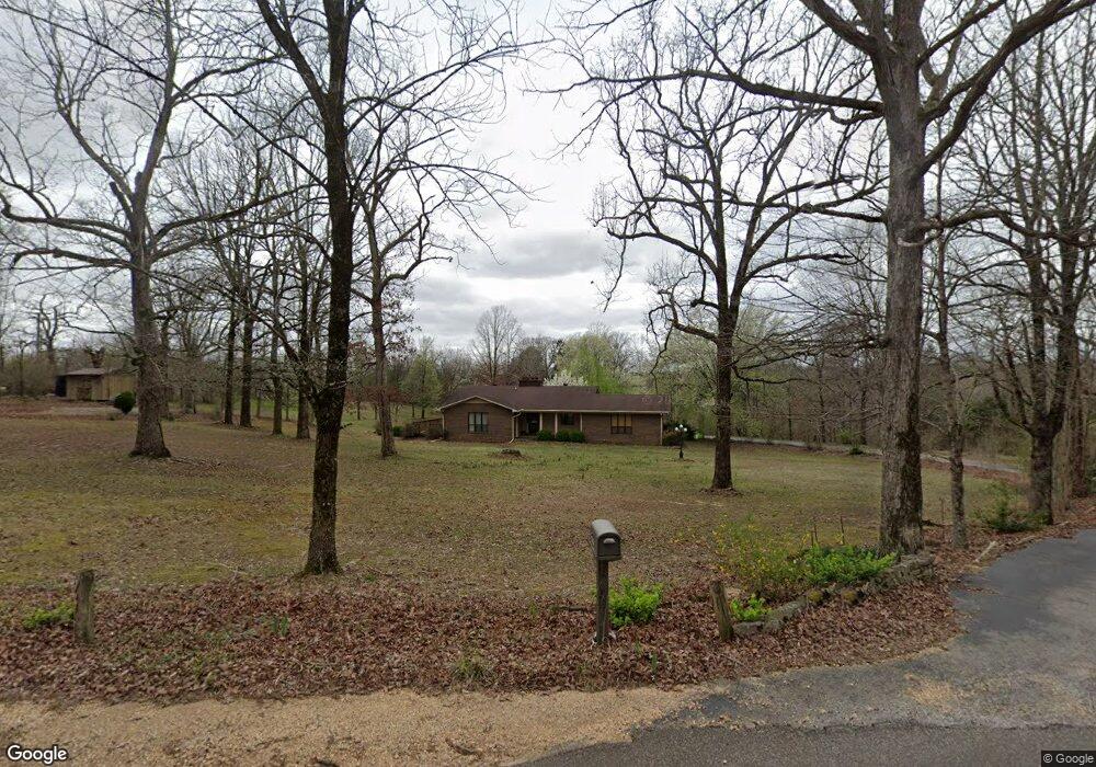
271 Herndon Rd Parsons, TN 38363
Estimated Value: $169,000 - $208,000
--
Bed
2
Baths
1,563
Sq Ft
$121/Sq Ft
Est. Value
About This Home
This home is located at 271 Herndon Rd, Parsons, TN 38363 and is currently estimated at $189,505, approximately $121 per square foot. 271 Herndon Rd is a home located in Decatur County with nearby schools including Parsons Elementary School, Decaturville Elementary School, and Decatur County Middle School.
Ownership History
Date
Name
Owned For
Owner Type
Purchase Details
Closed on
Oct 10, 2025
Sold by
Herndon Holland Jo Ellen
Bought by
Thornton Anthony Allen and Thornton Levi Allen
Current Estimated Value
Purchase Details
Closed on
Oct 27, 2016
Sold by
Herndon Holland Jo Ellen
Bought by
Thornton Anthony Allen and Thornton Levi Allen
Purchase Details
Closed on
Dec 5, 1986
Bought by
Holland Jo Ellen
Create a Home Valuation Report for This Property
The Home Valuation Report is an in-depth analysis detailing your home's value as well as a comparison with similar homes in the area
Home Values in the Area
Average Home Value in this Area
Purchase History
| Date | Buyer | Sale Price | Title Company |
|---|---|---|---|
| Thornton Anthony Allen | -- | None Listed On Document | |
| Thornton Anthony Allen | -- | None Listed On Document | |
| Holland Jo Ellen | -- | -- |
Source: Public Records
Tax History Compared to Growth
Tax History
| Year | Tax Paid | Tax Assessment Tax Assessment Total Assessment is a certain percentage of the fair market value that is determined by local assessors to be the total taxable value of land and additions on the property. | Land | Improvement |
|---|---|---|---|---|
| 2025 | $840 | $65,925 | $0 | $0 |
| 2024 | $840 | $32,550 | $1,425 | $31,125 |
| 2023 | $840 | $32,550 | $1,425 | $31,125 |
| 2022 | $840 | $32,550 | $1,425 | $31,125 |
| 2021 | $840 | $32,550 | $1,425 | $31,125 |
| 2020 | $840 | $32,550 | $1,425 | $31,125 |
| 2019 | $722 | $32,100 | $1,425 | $30,675 |
| 2018 | $639 | $32,100 | $1,425 | $30,675 |
| 2017 | $639 | $32,100 | $1,425 | $30,675 |
| 2016 | $626 | $31,450 | $1,450 | $30,000 |
| 2015 | $626 | $31,450 | $1,450 | $30,000 |
| 2014 | $626 | $31,449 | $0 | $0 |
Source: Public Records
Map
Nearby Homes
- 2122 Old Decaturville Rd
- 195 Glen Rich Dr
- 174 Grice Ln
- 869 W 4th St
- 724 Tennessee Ave S
- 545 W 4th St
- 41 E 7th St
- 109 Durbin Ln
- 91 E 2nd St
- x Highway 641 Hwy
- 0 E Main St Unit 242952
- 320 Wilkinstown Rd
- 0 Wilkinstown Rd
- 279 Evans St
- 280 Evans St
- 702 E White Oak St
- 500 Oakville Cir
- 559 Oakville Cir
- 104 Oakwood Dr
- 0 Middleburg Rd