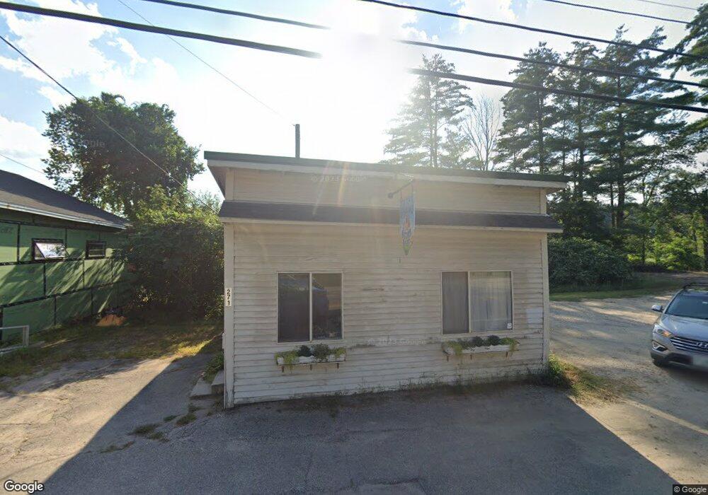
271 Lake St Bristol, NH 03222
Estimated Value: $101,823
--
Bed
1
Bath
588
Sq Ft
$173/Sq Ft
Est. Value
About This Home
This home is located at 271 Lake St, Bristol, NH 03222 and is currently priced at $101,823, approximately $173 per square foot. 271 Lake St is a home located in Grafton County with nearby schools including Bristol Elementary School.
Ownership History
Date
Name
Owned For
Owner Type
Purchase Details
Closed on
Dec 27, 2023
Sold by
Congdon Keith N and Congdon Deborah L
Bought by
Duba Donald R and Duba Margaret F
Current Estimated Value
Purchase Details
Closed on
May 31, 2013
Sold by
Platts Bruce K
Bought by
Platts Bruce K and Foster Faye D
Purchase Details
Closed on
Nov 27, 2002
Sold by
Jardine Brenda
Bought by
Foster Faye D
Create a Home Valuation Report for This Property
The Home Valuation Report is an in-depth analysis detailing your home's value as well as a comparison with similar homes in the area
Home Values in the Area
Average Home Value in this Area
Purchase History
| Date | Buyer | Sale Price | Title Company |
|---|---|---|---|
| Duba Donald R | $30,000 | None Available | |
| Duba Donald R | $30,000 | None Available | |
| Platts Bruce K | -- | -- | |
| Platts Bruce K | -- | -- | |
| Foster Faye D | $42,000 | -- | |
| Foster Faye D | $42,000 | -- |
Source: Public Records
Tax History Compared to Growth
Tax History
| Year | Tax Paid | Tax Assessment Tax Assessment Total Assessment is a certain percentage of the fair market value that is determined by local assessors to be the total taxable value of land and additions on the property. | Land | Improvement |
|---|---|---|---|---|
| 2024 | $1,405 | $59,500 | $26,200 | $33,300 |
| 2023 | $1,354 | $59,500 | $26,200 | $33,300 |
| 2022 | $1,484 | $70,700 | $36,600 | $34,100 |
| 2021 | $1,429 | $70,700 | $36,600 | $34,100 |
| 2020 | $1,463 | $70,700 | $36,600 | $34,100 |
| 2019 | $1,603 | $70,300 | $34,300 | $36,000 |
| 2018 | $1,533 | $70,300 | $34,300 | $36,000 |
| 2017 | $1,556 | $70,300 | $34,300 | $36,000 |
| 2016 | $1,450 | $70,300 | $34,300 | $36,000 |
| 2015 | $1,369 | $68,000 | $31,600 | $36,400 |
| 2014 | $1,369 | $68,000 | $31,600 | $36,400 |
| 2013 | $1,372 | $68,000 | $31,600 | $36,400 |
Source: Public Records
Map
Nearby Homes
- 333 Lake St
- 135 Pleasant St
- 29 Daniels Rd
- 30 Beech St Unit 4B
- 30 Beech St Unit 4C
- Lot 7 Hall Rd
- 00 Borough Rd Unit 1,2
- 26 Don Gerry Rd
- 150 Peaked Hill Rd
- 35 Manor Estates Dr Unit 14
- 94 Mandi Ln
- 00 Peaked Hill Rd Unit 7.1, 7.2, 7.3, 7.4,
- 383 Wulamat Rd
- 199 Cottage City Rd
- 40 Adams Rd
- 80 Patten Rd
- 125 Verrill Rd
- 114 Ledgewood Terrace
- 862 Mayhew Turnpike Unit 1
- 571 New Hampshire 104
- 10 Ridge Rd Unit 10
- 12 Bristol Hill Rd
- 265 Lake St
- 280 Lake Street Aka Route 3a
- 280 Lake St Unit 3
- 280 Lake St Unit 2
- 280 Lake St
- 254 Lake St
- 270 Lake St
- 290 Lake St
- 18 Hillside Ave
- 260 Lake St Unit 7
- 260 Lake St Unit 8
- 260 Lake St Unit 3a
- 260 Lake St Unit 1
- 260 Lake St Unit 4
- 260 Lake St Unit 6
- 260 Lake St
- 24 Hillside Ave
- 31 Bristol Hill Rd