
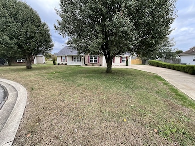
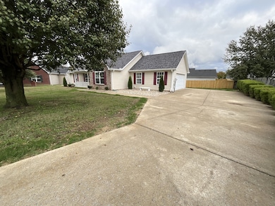


2712 Pickards Point La Vergne, TN 37086
Estimated payment $2,299/month
Highlights
- Open Floorplan
- High Ceiling
- Covered Patio or Porch
- Cape Cod Architecture
- No HOA
- Stainless Steel Appliances
About This Home
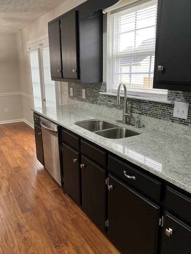
Welcome to this beautifully updated 3-bedroom, 2-bathroom home offering 1,316 sq ft of stylish living space. Every detail has been thoughtfully upgraded to provide a modern and elegant feel throughout. The kitchen has been completely transformed with new granite countertops, tiled backsplash. A brand new Samsung stainless steel appliance package installed. Fresh interior paint, new flooring & fixtures throughout the home, new locks and hardware, new glass security door. This home has a new roof and HVAC system for peace of mind. Contemporary designed landscaping for curb appeal. Serene surroundings & no HOA.
This home is move-in ready and perfect for buyers seeking comfort, style, and value. Location is key! Minutes outside of Nashville with convenient access to I-24, Murfreesboro Rd and dozens of amenities, restaurants, shopping, schools, and parks.
Listing Agent
American Heritage Inc. Brokerage Phone: 6158123655 License #341872 Listed on: 11/05/2025
Home Details
Home Type
- Single Family
Est. Annual Taxes
- $1,739
Year Built
- Built in 2000
Lot Details
- 0.25 Acre Lot
- Cul-De-Sac
Parking
- 2 Car Attached Garage
- Driveway
Home Design
- Cape Cod Architecture
- Brick Exterior Construction
- Frame Construction
- Shingle Roof
- Vinyl Siding
Interior Spaces
- 1,361 Sq Ft Home
- Property has 1 Level
- Open Floorplan
- High Ceiling
- Ceiling Fan
- Utility Room
- Washer and Electric Dryer Hookup
Kitchen
- Eat-In Kitchen
- Microwave
- Dishwasher
- Stainless Steel Appliances
- Smart Appliances
- ENERGY STAR Qualified Appliances
Bedrooms and Bathrooms
- 3 Main Level Bedrooms
- Walk-In Closet
- 2 Full Bathrooms
Outdoor Features
- Covered Patio or Porch
Schools
- Roy L Waldron Elementary School
- Lavergne Middle School
- Lavergne High School
Utilities
- Central Heating and Cooling System
- High Speed Internet
- Satellite Dish
- Cable TV Available
Community Details
- No Home Owners Association
- Madison Square Sec 2 Subdivision
Listing and Financial Details
- Assessor Parcel Number 015L C 04300 R0006398
Map
Home Values in the Area
Average Home Value in this Area
Tax History
| Year | Tax Paid | Tax Assessment Tax Assessment Total Assessment is a certain percentage of the fair market value that is determined by local assessors to be the total taxable value of land and additions on the property. | Land | Improvement |
|---|---|---|---|---|
| 2025 | $1,353 | $72,100 | $13,750 | $58,350 |
| 2024 | $1,353 | $72,100 | $13,750 | $58,350 |
| 2023 | $1,353 | $72,100 | $13,750 | $58,350 |
| 2022 | $1,165 | $72,100 | $13,750 | $58,350 |
| 2021 | $955 | $43,025 | $8,750 | $34,275 |
| 2020 | $955 | $43,025 | $8,750 | $34,275 |
| 2019 | $955 | $43,025 | $8,750 | $34,275 |
| 2018 | $1,208 | $43,025 | $0 | $0 |
| 2017 | $1,154 | $31,775 | $0 | $0 |
| 2016 | $1,154 | $31,775 | $0 | $0 |
| 2015 | $1,162 | $31,775 | $0 | $0 |
| 2014 | $790 | $31,775 | $0 | $0 |
| 2013 | -- | $31,625 | $0 | $0 |
Property History
| Date | Event | Price | List to Sale | Price per Sq Ft |
|---|---|---|---|---|
| 11/05/2025 11/05/25 | For Sale | $409,500 | -- | $301 / Sq Ft |
Purchase History
| Date | Type | Sale Price | Title Company |
|---|---|---|---|
| Quit Claim Deed | -- | None Listed On Document | |
| Quit Claim Deed | -- | None Listed On Document | |
| Interfamily Deed Transfer | -- | None Available | |
| Deed | -- | -- | |
| Deed | $131,250 | -- |
Source: Realtracs
MLS Number: 3039872
APN: 015L-C-043.00-000
Disclaimer: Certain information contained herein is derived from information provided by parties other than Homes.com. All information provided is deemed reliable, but is not guaranteed to be accurate and should be independently verified.
![]() Based on information submitted to the MLS GRID. All data is obtained from various sources and may not have been verified by broker or MLS GRID. Supplied Open House Information is subject to change without notice. All information should be independently reviewed and verified for accuracy. Properties may or may not be listed by the office/agent presenting the information. Some IDX listings have been excluded from this website.
Based on information submitted to the MLS GRID. All data is obtained from various sources and may not have been verified by broker or MLS GRID. Supplied Open House Information is subject to change without notice. All information should be independently reviewed and verified for accuracy. Properties may or may not be listed by the office/agent presenting the information. Some IDX listings have been excluded from this website.
The Digital Millennium Copyright Act of 1998, 17 U.S.C. § 512 (the “DMCA”) provides recourse for copyright owners who believe that material appearing on the Internet infringes their rights under U.S. copyright law. If you believe in good faith that any content or material made available in connection with our website or services infringes your copyright, you (or your agent) may send us a notice requesting that the content or material be removed, or access to it blocked.
Notices must be sent in writing by email to DMCAnotice@MLSGrid.com.
The DMCA requires that your notice of alleged copyright infringement include the following information:
(1) description of the copyrighted work that is the subject of claimed infringement;
(2) description of the alleged infringing content and information sufficient to permit us to locate the content;
(3) contact information for you, including your address, telephone number and email address;
(4) a statement by you that you have a good faith belief that the content in the manner complained of is not authorized by the copyright owner, or its agent, or by the operation of any law;
(5) a statement by you, signed under penalty of perjury, that the information in the notification is accurate and that you have the authority to enforce the copyrights that are claimed to be infringed; and
(6) a physical or electronic signature of the copyright owner or a person authorized to act on the copyright owner’s behalf. Failure to include all of the above information may result in the delay of the processing of your complaint.
- 317 Liberty Ln
- 1093 Moss Trail
- 5561 Hickory Woods Dr
- 613 Sycamore Ln
- 7511 Cash Crossing Ct
- 4237 Miranda Place
- 178 Ramsden Ave
- 6416 Wildgrove Dr
- 7022 Alon Babayan Arch
- 150 Bluegill Ln
- 4414 Maxwell Rd
- 144 Ramsden Ave
- 146 Ramsden Ave
- 319 Carp Ct
- 317 Carp Ct
- 313 Carp Ct
- 152 Bluegill Ln
- 188 Sophie Dr
- 5007 73rd Ave
- 148 Bluegill Ln
- 4112 Nir Shreibman Blvd
- 2108 Montgomery Ln
- 2001 Madison Square Blvd
- 279 Stones River Rd
- 6628 Shadyview Dr
- 5129 Brookstone Ct
- 3020 73rd Ave
- 3020 73rd Ave
- 5067 Trailwater Dr
- 5112 Brookstone Ct
- 975 Evie Ann Ln
- 1 Rutherford Point Cir
- 5221 Lake Maxwell Dr
- 5216 Lake Maxwell Dr
- 4812 Chutney Dr
- 3868 Round Rock Dr
- 1353 Lomond Dr
- 1323 Lomond Dr
- 4774 Chutney Dr
- 4325 Mystic Valley Ct
