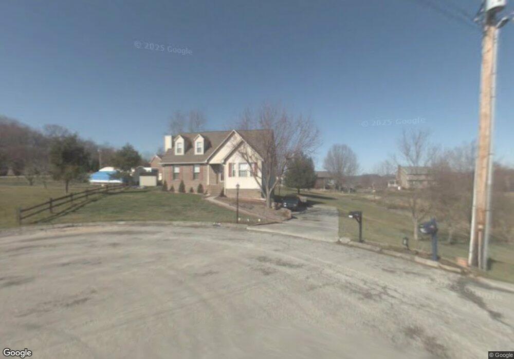
2715 Cannon Cir Morristown, TN 37814
Estimated Value: $324,325 - $414,000
--
Bed
3
Baths
1,720
Sq Ft
$216/Sq Ft
Est. Value
About This Home
This home is located at 2715 Cannon Cir, Morristown, TN 37814 and is currently estimated at $371,581, approximately $216 per square foot. 2715 Cannon Cir is a home located in Hamblen County with nearby schools including Russellville Elementary School, East Ridge Middle School, and Morristown East High School.
Ownership History
Date
Name
Owned For
Owner Type
Purchase Details
Closed on
Mar 5, 1997
Bought by
Hayes Charles and Hayes Cora
Current Estimated Value
Purchase Details
Closed on
Feb 16, 1993
Bought by
Davidson George E and Davidson Charlotte M
Purchase Details
Closed on
May 12, 1987
Bought by
Cannon Bobby Joe and Charlotte Earlen
Purchase Details
Closed on
Apr 13, 1984
Bought by
Seals Larry Dale
Purchase Details
Closed on
Sep 8, 1979
Bought by
Breeding Lynn E
Create a Home Valuation Report for This Property
The Home Valuation Report is an in-depth analysis detailing your home's value as well as a comparison with similar homes in the area
Home Values in the Area
Average Home Value in this Area
Purchase History
| Date | Buyer | Sale Price | Title Company |
|---|---|---|---|
| Hayes Charles | $16,000 | -- | |
| Davidson George E | $84,900 | -- | |
| Cannon Bobby Joe | $12,300 | -- | |
| Seals Larry Dale | -- | -- | |
| Breeding Lynn E | -- | -- |
Source: Public Records
Tax History Compared to Growth
Tax History
| Year | Tax Paid | Tax Assessment Tax Assessment Total Assessment is a certain percentage of the fair market value that is determined by local assessors to be the total taxable value of land and additions on the property. | Land | Improvement |
|---|---|---|---|---|
| 2024 | $816 | $41,425 | $7,650 | $33,775 |
| 2023 | $816 | $41,425 | $0 | $0 |
| 2022 | $816 | $41,425 | $7,650 | $33,775 |
| 2021 | $816 | $41,425 | $7,650 | $33,775 |
| 2020 | $816 | $41,425 | $7,650 | $33,775 |
| 2019 | $756 | $35,475 | $6,800 | $28,675 |
| 2018 | $756 | $35,475 | $6,800 | $28,675 |
| 2017 | $756 | $35,475 | $6,800 | $28,675 |
| 2016 | $706 | $35,475 | $6,800 | $28,675 |
| 2015 | $656 | $35,475 | $6,800 | $28,675 |
| 2014 | -- | $35,475 | $6,800 | $28,675 |
| 2013 | -- | $39,625 | $0 | $0 |
Source: Public Records
Map
Nearby Homes
- 4959 Brights Pike
- 4119 Azalea Ct
- 2551 Cedar Creek Rd
- 5110 Anne Cir
- 4801 Harbor Dr
- 4547 Brights Pike
- 5601 Brights Pike
- 3800 Dan Dr
- Lot 17 Waters Edge Dr
- 5556 Denton Dr
- 3083 Waters Edge Dr
- 4475 Copeland Dr
- 5659 Browning Way
- 3835 High Oak Dr
- 4110 Harbor View Dr
- 4146 Leslie Dr
- 4086 Harbor View Dr
- 1708 Boardwalk Cir
- 4041 Harbor View Dr
- 2145 Fall Creek Rd
- 2720 Cannon Cir
- 2677 Scenic Lake Cir
- 2711 Cannon Cir
- 2647 Scenic Lake Cir
- 2627 Scenic Lake Cir
- 2710 Cannon Cir
- 2767 Scenic Lake Cir
- 2787 Scenic Lake Cir
- 2797 Scenic Lake Cir
- 2111 Cannon Cir
- 2827 Scenic Lake Cir
- 2897 Scenic Lake Cir
- 2634 Scenic Lake Cir
- 2620 Scenic Lake Cir
- 2837 Scenic Lake Cir
- 2744 Scenic Lake Cir
- 2754 Scenic Lake Cir
- 2764 Scenic Lake Cir
- 2774 Scenic Lake Cir
- 2804 Scenic Lake Cir