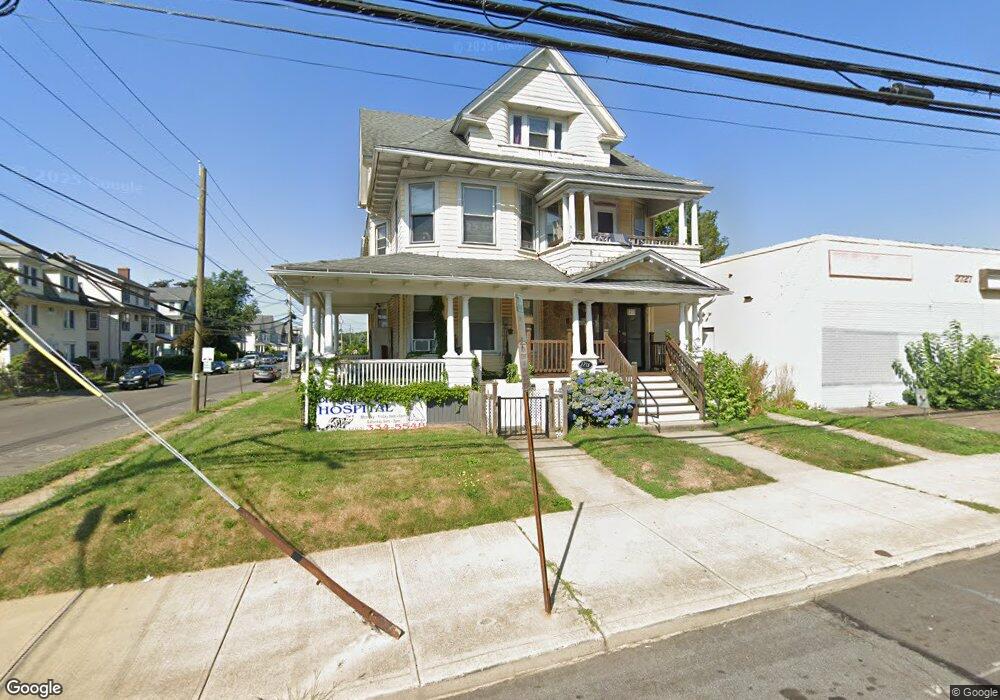
2715 Main St Unit 2717 Bridgeport, CT 06606
Brooklawn-Saint Vincent NeighborhoodEstimated Value: $489,000 - $1,805,738
8
Beds
3
Baths
3,861
Sq Ft
$240/Sq Ft
Est. Value
About This Home
This home is located at 2715 Main St Unit 2717, Bridgeport, CT 06606 and is currently estimated at $925,435, approximately $239 per square foot. 2715 Main St Unit 2717 is a home located in Fairfield County with nearby schools including Madison School, Central High School, and Catholic Academy of Bridgeport-St. Raphael Academy.
Ownership History
Date
Name
Owned For
Owner Type
Purchase Details
Closed on
Mar 18, 1996
Sold by
Greengarden Mark
Bought by
Reddy Bandaru and Reddy Rajani
Current Estimated Value
Home Financials for this Owner
Home Financials are based on the most recent Mortgage that was taken out on this home.
Original Mortgage
$275,000
Interest Rate
6.97%
Mortgage Type
Unknown
Create a Home Valuation Report for This Property
The Home Valuation Report is an in-depth analysis detailing your home's value as well as a comparison with similar homes in the area
Home Values in the Area
Average Home Value in this Area
Purchase History
| Date | Buyer | Sale Price | Title Company |
|---|---|---|---|
| Reddy Bandaru | $454,000 | -- | |
| Reddy Bandaru | $454,000 | -- |
Source: Public Records
Mortgage History
| Date | Status | Borrower | Loan Amount |
|---|---|---|---|
| Closed | Reddy Bandaru | $275,000 | |
| Previous Owner | Reddy Bandaru | $350,000 | |
| Closed | Reddy Bandaru | $126,000 |
Source: Public Records
Tax History Compared to Growth
Tax History
| Year | Tax Paid | Tax Assessment Tax Assessment Total Assessment is a certain percentage of the fair market value that is determined by local assessors to be the total taxable value of land and additions on the property. | Land | Improvement |
|---|---|---|---|---|
| 2025 | $6,361 | $146,397 | $56,427 | $89,970 |
| 2024 | $6,361 | $146,397 | $56,427 | $89,970 |
| 2023 | $6,361 | $146,397 | $56,427 | $89,970 |
| 2022 | $6,361 | $146,397 | $56,427 | $89,970 |
| 2021 | $6,361 | $146,397 | $56,427 | $89,970 |
| 2020 | $7,376 | $136,620 | $31,890 | $104,730 |
| 2019 | $7,376 | $136,620 | $31,890 | $104,730 |
| 2018 | $7,428 | $136,620 | $31,890 | $104,730 |
| 2017 | $7,428 | $136,620 | $31,890 | $104,730 |
| 2016 | $7,428 | $136,620 | $31,890 | $104,730 |
| 2015 | $8,099 | $191,920 | $38,580 | $153,340 |
| 2014 | $8,099 | $191,920 | $38,580 | $153,340 |
Source: Public Records
Map
Nearby Homes
- 330 French St
- 508 Hawley Ave
- 724 Capitol Ave Unit 726
- 119 Madison Terrace
- 2395 Main St Unit 2397
- 936 Lindley St
- 106 Manhattan Ave Unit 108
- 980 Lindley St Unit 401
- 123 Harlem Ave
- 390 Charles St Unit 106
- 390 Charles St Unit 216
- 252 Harlem Ave Unit B6
- 76 Porter St
- 926 Hart St
- 916 Hart St
- 110 Quince St
- 105 Tremont Ave Unit E
- 137 Holroyd St
- 631 Fairview Ave
- 125 Sampson St
- 2717 Main St Unit 2
- 2697 Main St
- 2689 Main St
- 2738 Main St
- 46 Marion St
- 2727 Main St
- 25 Marion St Unit 27
- 2735 Main St
- 2736 Main St Unit 1st Flr
- 2677 Main St Unit 2679
- 2677 Main St Unit 2
- 33 Marion St Unit 35
- 33 Marion St Unit 1st Fl.
- 2744 Main St Unit 2746
- 2744 Main St Unit 1st F
- 2669 Main St Unit 2671
- 2754 Main St Unit 2756
- 49 Marion St
- 47 Marion St Unit 49
- 349 Hawley Ave Unit 351