Estimated Value: $468,000 - $674,000
4
Beds
3
Baths
2,924
Sq Ft
$187/Sq Ft
Est. Value
About This Home
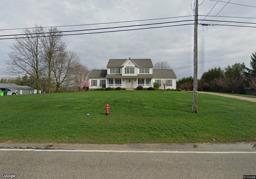
This home is located at 2717 N River Rd, Stow, OH 44224 and is currently estimated at $545,400, approximately $186 per square foot. 2717 N River Rd is a home located in Summit County with nearby schools including Stow-Munroe Falls High School, Holy Family Elementary School, and St Patrick Elementary School.
Ownership History
Date
Name
Owned For
Owner Type
Purchase Details
Closed on
May 23, 2024
Sold by
Platt John Parker and Platt Michele Lynn
Bought by
Platt Michele Lynn
Current Estimated Value
Purchase Details
Closed on
Mar 28, 2006
Sold by
Perez Dale and Perez Juliann M
Bought by
Platt John Parker and Platt Michele Lynn
Home Financials for this Owner
Home Financials are based on the most recent Mortgage that was taken out on this home.
Original Mortgage
$265,000
Interest Rate
6.38%
Mortgage Type
Fannie Mae Freddie Mac
Purchase Details
Closed on
Jul 8, 2003
Sold by
Beltram Gary E and Beltram Doris J
Bought by
Perez Dale and Perez Juliann M
Home Financials for this Owner
Home Financials are based on the most recent Mortgage that was taken out on this home.
Original Mortgage
$87,600
Interest Rate
5.3%
Mortgage Type
Purchase Money Mortgage
Create a Home Valuation Report for This Property
The Home Valuation Report is an in-depth analysis detailing your home's value as well as a comparison with similar homes in the area
Home Values in the Area
Average Home Value in this Area
Purchase History
| Date | Buyer | Sale Price | Title Company |
|---|---|---|---|
| Platt Michele Lynn | -- | None Listed On Document | |
| Platt John Parker | $355,000 | Buckeye Reserve Title Agency | |
| Perez Dale | $109,500 | Minnesota |
Source: Public Records
Mortgage History
| Date | Status | Borrower | Loan Amount |
|---|---|---|---|
| Previous Owner | Platt John Parker | $265,000 | |
| Previous Owner | Perez Dale | $87,600 |
Source: Public Records
Tax History
| Year | Tax Paid | Tax Assessment Tax Assessment Total Assessment is a certain percentage of the fair market value that is determined by local assessors to be the total taxable value of land and additions on the property. | Land | Improvement |
|---|---|---|---|---|
| 2024 | $7,884 | $140,421 | $17,154 | $123,267 |
| 2023 | $7,884 | $140,421 | $17,154 | $123,267 |
| 2022 | $7,019 | $110,349 | $13,402 | $96,947 |
| 2021 | $6,281 | $110,349 | $13,402 | $96,947 |
| 2020 | $6,173 | $110,350 | $13,400 | $96,950 |
| 2019 | $6,831 | $114,250 | $22,900 | $91,350 |
| 2018 | $6,719 | $114,250 | $22,900 | $91,350 |
| 2017 | $6,491 | $114,250 | $22,900 | $91,350 |
| 2016 | $6,682 | $107,270 | $22,900 | $84,370 |
| 2015 | $6,491 | $107,270 | $22,900 | $84,370 |
| 2014 | $6,497 | $107,270 | $22,900 | $84,370 |
| 2013 | $6,586 | $109,460 | $22,900 | $86,560 |
Source: Public Records
Map
Nearby Homes
- 3209 Pimlico Blvd
- 3474 Churchill Downs
- 537 Park Ridge Dr
- 374 N River Rd
- 1330 Chelton Dr
- 458 Irma St
- 3905 Kent Rd
- 245 Bermont Ave
- 1138 Lower Dr
- 0 Middlebury Rd
- 1245 Chelton Dr
- 3767 Lake Run Blvd
- 1285 Gale Dr
- 350 Silver Meadows Blvd
- 1165 Hampton Rd
- 3313 Crown Pointe Dr
- 3958 Lake Run Blvd
- 726 Hughey Dr
- 2535 Sears Rd
- 3828 Osage St Unit 3832
- 3226 Suffolk Downs
- 2705 N River Rd
- 0 Suffolk Downs 21
- 0 Suffolk Downs 24
- 0 Suffolk Downs 19
- 0 Suffolk Downs 28
- 0 Suffolk Downs 2
- 0 Suffolk Downs 25
- 0 Suffolk Downs 14
- 0 Suffolk Downs 1
- 3214 Suffolk Downs
- 2695 N River Rd
- 3245 Suffolk Downs
- 2764 Hialeah Cir
- 2772 Hialeah Cir
- 3257 Suffolk Downs
- 2675 N River Rd
- 0 2 Suffolk Downs
- 3269 Suffolk Downs
- 2756 Hialeah Cir
Your Personal Tour Guide
Ask me questions while you tour the home.