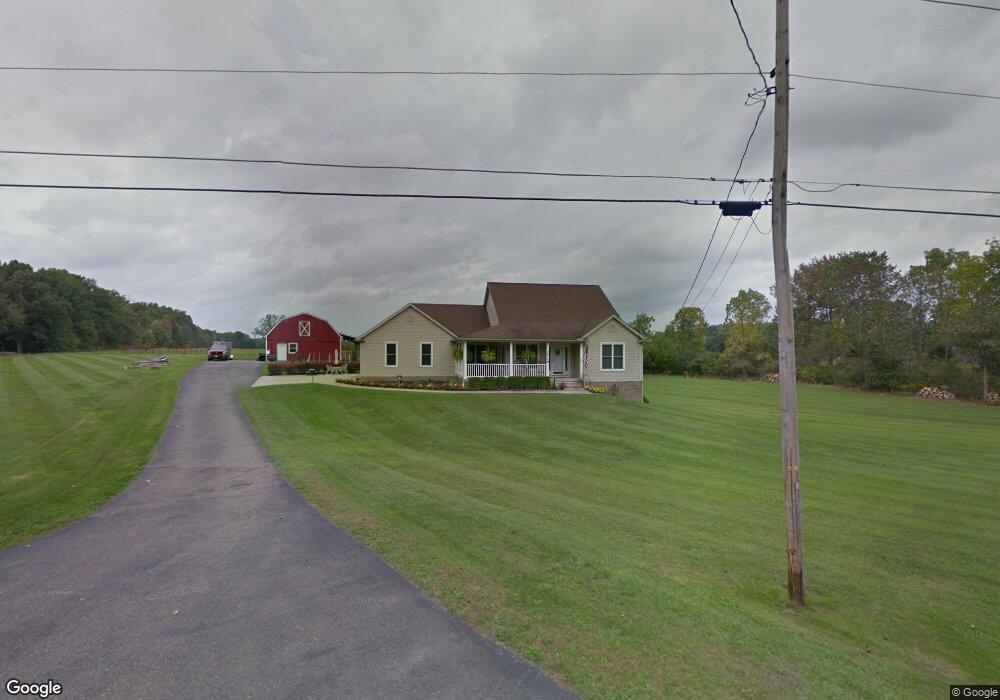
2719 Barlow Rd Hudson, OH 44236
Estimated Value: $353,000 - $434,122
3
Beds
2
Baths
1,524
Sq Ft
$261/Sq Ft
Est. Value
About This Home
This home is located at 2719 Barlow Rd, Hudson, OH 44236 and is currently estimated at $397,781, approximately $261 per square foot. 2719 Barlow Rd is a home located in Summit County with nearby schools including Ellsworth Hill Elementary School, East Woods Intermediate School, and Hudson Middle School.
Ownership History
Date
Name
Owned For
Owner Type
Purchase Details
Closed on
Aug 21, 2017
Sold by
Hillyard Frank W and Hillyard Terri L
Bought by
Hillyard Ffrank W and Hillyard Terrilyn L
Current Estimated Value
Purchase Details
Closed on
Apr 26, 2002
Sold by
Barlow Janet F and Defer Faith Barlow
Bought by
Hillyard Frank W and Hillyard Terri L
Create a Home Valuation Report for This Property
The Home Valuation Report is an in-depth analysis detailing your home's value as well as a comparison with similar homes in the area
Home Values in the Area
Average Home Value in this Area
Purchase History
| Date | Buyer | Sale Price | Title Company |
|---|---|---|---|
| Hillyard Ffrank W | -- | Fireland Title | |
| Vizmeg George | $35,200 | None Available | |
| Hillyard Frank W | $45,000 | Chicago Title Insurance Comp |
Source: Public Records
Tax History Compared to Growth
Tax History
| Year | Tax Paid | Tax Assessment Tax Assessment Total Assessment is a certain percentage of the fair market value that is determined by local assessors to be the total taxable value of land and additions on the property. | Land | Improvement |
|---|---|---|---|---|
| 2025 | $6,251 | $132,829 | $23,982 | $108,847 |
| 2024 | $6,251 | $132,829 | $23,982 | $108,847 |
| 2023 | $6,251 | $132,829 | $23,982 | $108,847 |
| 2022 | $4,842 | $94,224 | $16,769 | $77,455 |
| 2021 | $4,850 | $94,224 | $16,769 | $77,455 |
| 2020 | $4,764 | $94,230 | $16,770 | $77,460 |
| 2019 | $5,052 | $92,670 | $14,560 | $78,110 |
| 2018 | $5,613 | $92,670 | $14,560 | $78,110 |
| 2017 | $4,122 | $88,910 | $10,800 | $78,110 |
| 2016 | $4,152 | $75,560 | $11,240 | $64,320 |
| 2015 | $4,122 | $75,560 | $11,240 | $64,320 |
| 2014 | $4,598 | $83,070 | $11,240 | $71,830 |
| 2013 | $3,763 | $68,170 | $9,580 | $58,590 |
Source: Public Records
Map
Nearby Homes
- 5431 Diana Lynn Dr
- 5473 Young Rd
- 2749 Norton Rd
- 5465 Park Vista Ct
- 5241 Brockton Dr
- V/L Ravenna Rd
- 4901 Pebblehurst Dr
- V/L Norton Rd
- 1884 Village Ct Unit X66
- 4917 Independence Cir Unit B
- 1759 E Sapphire Dr
- 5139 Rockport Cove
- 2327 Crockett Cir
- 4901 Independence Cir Unit B
- 139 Mccracken Rd
- 2380 Port Williams Dr Unit 2380
- 4731 Haughton Ct
- 2444 Port Charles Dr
- 1620 Sapphire Dr
- 4621 Graford Ln
- 5521 Stonecreek Way
- 2682 Barlow Rd
- 5533 Stonecreek Way
- 5539 Stonecreek Way
- 2670 Barlow Rd
- V/L Stonecreek Way
- 5522 Stonecreek Way
- 5547 Stonecreek Way
- 2660 Barlow Rd
- 5530 Stonecreek Way
- 5555 Stonecreek Way
- 2570 Brafferton Ave
- 5538 Stonecreek Way
- 0 VL Stonecreek Way
- 2650 Barlow Rd
- 5563 Stonecreek Way
- 2569 Brafferton Ave
- 5546 Stonecreek Way
- 2640 Barlow Rd
- 5571 Stonecreek Way