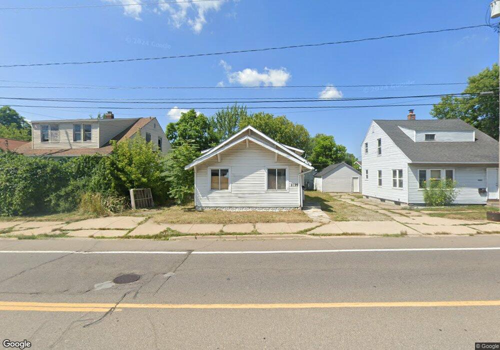
2720 Corunna Rd Flint, MI 48503
Mannhall Park NeighborhoodEstimated Value: $46,000 - $55,000
2
Beds
1
Bath
1,032
Sq Ft
$49/Sq Ft
Est. Value
About This Home
This home is located at 2720 Corunna Rd, Flint, MI 48503 and is currently estimated at $50,197, approximately $48 per square foot. 2720 Corunna Rd is a home located in Genesee County with nearby schools including Durant-Tuuri-Mott Elementary School, St. Paul Lutheran School, and St John Vianney Catholic School.
Ownership History
Date
Name
Owned For
Owner Type
Purchase Details
Closed on
Dec 21, 2021
Sold by
Cherry Deborah L
Bought by
Genesee County Land Bank Authority
Current Estimated Value
Purchase Details
Closed on
Mar 26, 2018
Sold by
Langer Crstal
Bought by
Porras Francisco
Purchase Details
Closed on
Mar 9, 2018
Sold by
Cook Brian
Bought by
Lancer Crystal
Purchase Details
Closed on
Feb 19, 2016
Sold by
Isaac Christopher
Bought by
Cook Brian
Purchase Details
Closed on
Sep 8, 2015
Sold by
Cook Brian
Bought by
Isaac Chris
Purchase Details
Closed on
Sep 4, 2015
Sold by
Zerilli Matthew
Bought by
Cook Brian
Create a Home Valuation Report for This Property
The Home Valuation Report is an in-depth analysis detailing your home's value as well as a comparison with similar homes in the area
Home Values in the Area
Average Home Value in this Area
Purchase History
| Date | Buyer | Sale Price | Title Company |
|---|---|---|---|
| Genesee County Land Bank Authority | -- | None Listed On Document | |
| Porras Francisco | $2,000 | Cilso Title Co | |
| Lancer Crystal | -- | Cislo Title Co | |
| Cook Brian | -- | Attorney | |
| Isaac Chris | $5,000 | None Available | |
| Cook Brian | -- | None Available |
Source: Public Records
Tax History
| Year | Tax Paid | Tax Assessment Tax Assessment Total Assessment is a certain percentage of the fair market value that is determined by local assessors to be the total taxable value of land and additions on the property. | Land | Improvement |
|---|---|---|---|---|
| 2025 | $1,421 | $18,600 | $0 | $0 |
| 2024 | $1,310 | $18,400 | $0 | $0 |
| 2023 | $1,275 | $15,400 | $0 | $0 |
| 2022 | $0 | $0 | $0 | $0 |
| 2021 | $926 | $11,400 | $0 | $0 |
| 2020 | $855 | $10,100 | $0 | $0 |
| 2019 | $838 | $8,800 | $0 | $0 |
| 2018 | $677 | $6,600 | $0 | $0 |
| 2017 | $662 | $0 | $0 | $0 |
| 2016 | $662 | $0 | $0 | $0 |
| 2015 | -- | $0 | $0 | $0 |
| 2014 | -- | $0 | $0 | $0 |
| 2012 | -- | $8,300 | $0 | $0 |
Source: Public Records
Map
Nearby Homes
- 2621 Swayze St
- 2618 Brown St
- 932 Bradley Ave
- 2509 Corunna Rd
- 3018 Fielding St
- 2464 Gibson St
- 2729 Chicago Blvd
- 1017 Stocker Ave
- 1506 Gainey Ave
- 2433 Brown St
- 911 Hughes Ave
- 1122 Stocker Ave
- 2410 Corunna Rd
- 2437 Zimmerman St
- 915 Stocker Ave
- 960 Mann Ave
- 2310 Gibson St
- 976 Barney Ave
- 3217 Arlene Ave
- 3413 Augusta St
- 2724 Corunna Rd
- 2716 Corunna Rd
- 2728 Corunna Rd
- 2717 Reynolds St
- 2721 Reynolds St
- 2708 Corunna Rd
- 2704 Corunna Rd
- 2725 Reynolds St
- 2802 Corunna Rd
- 2801 Reynolds St
- 2705 Reynolds St
- 2700 Corunna Rd
- 2701 Reynolds St
- 2701 Corunna Rd
- 2718 Reynolds St
- 2809 Reynolds St
- 2722 Reynolds St
- 2726 Reynolds St
- 2718 Swayze St
- 2714 Swayze St
Your Personal Tour Guide
Ask me questions while you tour the home.