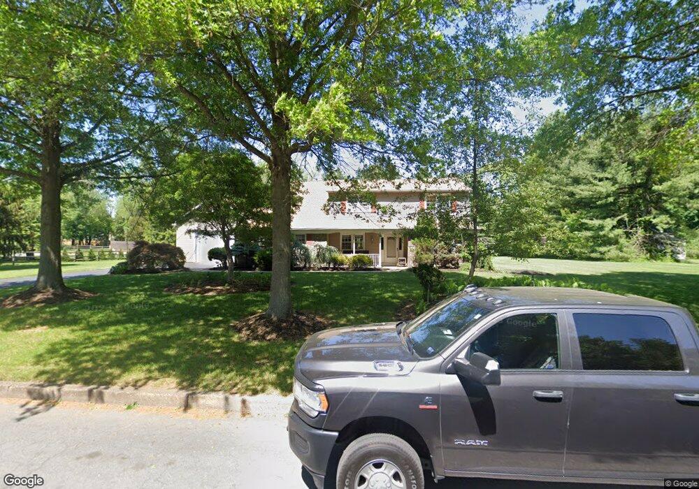
2727 Cranberry Rd Doylestown, PA 18902
Estimated Value: $720,000 - $907,000
3
Beds
3
Baths
3,000
Sq Ft
$264/Sq Ft
Est. Value
About This Home
This home is located at 2727 Cranberry Rd, Doylestown, PA 18902 and is currently estimated at $792,744, approximately $264 per square foot. 2727 Cranberry Rd is a home located in Bucks County with nearby schools including Buckingham Elementary School, Holicong Middle School, and Central Bucks High School - East.
Ownership History
Date
Name
Owned For
Owner Type
Purchase Details
Closed on
Sep 15, 2006
Sold by
Hess Eric J and Hess Jacqueline M
Bought by
Hess Eric J
Current Estimated Value
Purchase Details
Closed on
Jun 29, 1999
Sold by
Hess Eric John
Bought by
Hess Eric J and Hess Jacqueline M
Create a Home Valuation Report for This Property
The Home Valuation Report is an in-depth analysis detailing your home's value as well as a comparison with similar homes in the area
Home Values in the Area
Average Home Value in this Area
Purchase History
| Date | Buyer | Sale Price | Title Company |
|---|---|---|---|
| Hess Eric J | -- | None Available | |
| Hess Eric J | -- | -- |
Source: Public Records
Tax History Compared to Growth
Tax History
| Year | Tax Paid | Tax Assessment Tax Assessment Total Assessment is a certain percentage of the fair market value that is determined by local assessors to be the total taxable value of land and additions on the property. | Land | Improvement |
|---|---|---|---|---|
| 2025 | $7,631 | $46,870 | $8,130 | $38,740 |
| 2024 | $7,631 | $46,870 | $8,130 | $38,740 |
| 2023 | $7,372 | $46,870 | $8,130 | $38,740 |
| 2022 | $7,284 | $46,870 | $8,130 | $38,740 |
| 2021 | $7,197 | $46,870 | $8,130 | $38,740 |
| 2020 | $7,197 | $46,870 | $8,130 | $38,740 |
| 2019 | $7,150 | $46,870 | $8,130 | $38,740 |
| 2018 | $7,150 | $46,870 | $8,130 | $38,740 |
| 2017 | $7,091 | $46,870 | $8,130 | $38,740 |
| 2016 | $7,162 | $46,870 | $8,130 | $38,740 |
| 2015 | -- | $46,870 | $8,130 | $38,740 |
| 2014 | -- | $46,870 | $8,130 | $38,740 |
Source: Public Records
Map
Nearby Homes
- 2728 Red Gate Dr
- 2880 Snake Hill Rd
- 2799 Manion Way
- 4604 Sands Way
- 2565 Bogarts Tavern Rd
- 4350 Church Rd
- 3111 Burnt House Hill Rd
- 3146 Mill Rd
- 3196 Mill Rd
- 2479 Wheatfield Ln
- 4245 Mechanicsville Rd
- 5025 Anderson Rd
- 3889 Robin Rd
- 4871 E Blossom Dr
- lot #3 next to 3739 York Rd
- 3015 Yorkshire Rd
- 3775 Buckingham Dr
- 3772 Powder Horn Dr
- 3555 Northview Ln
- 4928 Edgewood Rd
- 2745 Cranberry Rd
- 2711 Cranberry Rd
- 2734 Cranberry Rd
- 4524 Foothill Dr
- 4486 Foothill Dr
- 2698 Cranberry Rd
- 2754 Cranberry Rd
- 4475 Foothill Dr
- 2763 Cranberry Rd
- 4530 Foothill Dr
- 4495 Foothill Dr
- 4461 Foothill Dr
- 2699 Cranberry Rd
- 4415 Foothill Dr
- 2687 Cranberry Rd
- 4471 Route 202
- 2711 Red Gate Dr
- 4493 Route 202
- 4483 Foothill Dr
- 2774 Cranberry Rd