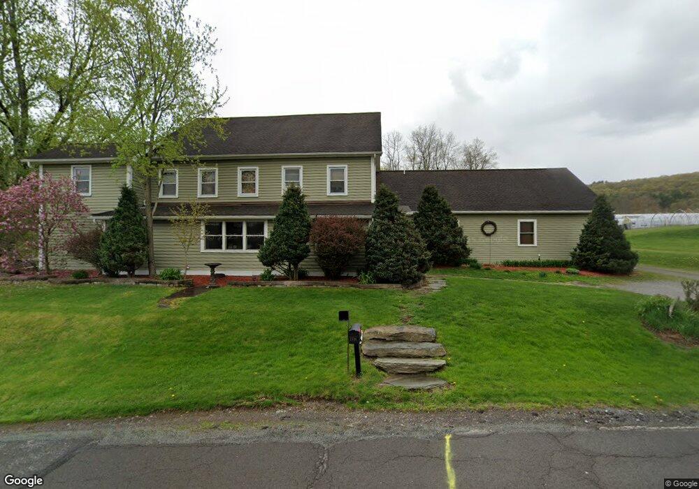
2730 Ransom Rd Dallas, PA 18612
Estimated Value: $448,000 - $550,664
4
Beds
4
Baths
3,781
Sq Ft
$132/Sq Ft
Est. Value
About This Home
This home is located at 2730 Ransom Rd, Dallas, PA 18612 and is currently estimated at $499,332, approximately $132 per square foot. 2730 Ransom Rd is a home located in Luzerne County with nearby schools including Dallas Senior High School.
Ownership History
Date
Name
Owned For
Owner Type
Purchase Details
Closed on
Aug 30, 2010
Sold by
Eaton Everal B and Ruger Hugh
Bought by
Ruger Hugh and Ruger Allison J
Current Estimated Value
Home Financials for this Owner
Home Financials are based on the most recent Mortgage that was taken out on this home.
Original Mortgage
$360,000
Outstanding Balance
$236,873
Interest Rate
4.37%
Mortgage Type
New Conventional
Estimated Equity
$262,459
Purchase Details
Closed on
Feb 26, 2009
Sold by
Ruger Allison J
Bought by
Ruger Hugh and Ruger Allison J
Home Financials for this Owner
Home Financials are based on the most recent Mortgage that was taken out on this home.
Original Mortgage
$195,500
Interest Rate
5.18%
Mortgage Type
New Conventional
Purchase Details
Closed on
Aug 17, 2006
Sold by
Eaton Everal B
Bought by
Ruger Allison J
Create a Home Valuation Report for This Property
The Home Valuation Report is an in-depth analysis detailing your home's value as well as a comparison with similar homes in the area
Home Values in the Area
Average Home Value in this Area
Purchase History
| Date | Buyer | Sale Price | Title Company |
|---|---|---|---|
| Ruger Hugh | -- | None Available | |
| Ruger Hugh | -- | None Available | |
| Ruger Allison J | -- | None Available |
Source: Public Records
Mortgage History
| Date | Status | Borrower | Loan Amount |
|---|---|---|---|
| Open | Ruger Hugh | $360,000 | |
| Closed | Ruger Hugh | $195,500 |
Source: Public Records
Tax History Compared to Growth
Tax History
| Year | Tax Paid | Tax Assessment Tax Assessment Total Assessment is a certain percentage of the fair market value that is determined by local assessors to be the total taxable value of land and additions on the property. | Land | Improvement |
|---|---|---|---|---|
| 2025 | $5,955 | $279,700 | $48,700 | $231,000 |
| 2024 | $5,768 | $279,700 | $48,700 | $231,000 |
| 2023 | $5,768 | $279,700 | $48,700 | $231,000 |
| 2022 | $5,717 | $279,700 | $48,700 | $231,000 |
| 2021 | $5,717 | $279,700 | $48,700 | $231,000 |
| 2020 | $5,717 | $279,700 | $48,700 | $231,000 |
| 2019 | $5,662 | $279,700 | $48,700 | $231,000 |
| 2018 | $5,606 | $279,700 | $48,700 | $231,000 |
| 2017 | $5,524 | $279,700 | $48,700 | $231,000 |
| 2016 | -- | $279,700 | $48,700 | $231,000 |
| 2015 | $4,750 | $279,700 | $48,700 | $231,000 |
| 2014 | $4,750 | $279,700 | $48,700 | $231,000 |
Source: Public Records
Map
Nearby Homes
- 456 Village Rd
- 765 Demunds Rd
- 745 Demunds Rd
- 507 Butternut Ln
- 0 Lockville Rd Church Rd Unit 25-1114
- 5 Manorview Dr
- 750 Slocum Ave
- 522 Sutton Creek Rd
- 101 Manorview Dr
- 0 Upper Demunds Rd
- LOT 2 Manorview Dr
- 100 Manorview Dr
- 633 Campground Rd
- 9 Circle Dr
- 2304 Pennsylvania 92
- 314 Terrace Ave
- 41 Gashi Rd
- 62 Scenicview
- 675 Apple Tree Rd
- 0 Brown Manor Lots
- 2812 Ransom Rd
- 2607 Ransom Rd
- 2886 Ransom Rd
- 2555 Ransom Rd
- 2513 Ransom Rd
- 2950 Ransom Rd
- 2120 W 8th St
- 416 Municipal Rd
- 78 Flat Rock Rd
- 54 Flat Rock Rd
- 2195 W 8th St
- 000 Municipal Rd
- 0 Municipal Rd
- 420 Municipal Rd
- 65 Flat Rock Rd
- 411 Municipal Rd
- 100 Hills Rd
- 38 Flat Rock Rd
- 424 Municipal Rd
- 2385 Ransom Rd