Estimated Value: $1,017,000 - $1,323,000
4
Beds
3
Baths
2,077
Sq Ft
$553/Sq Ft
Est. Value
About This Home
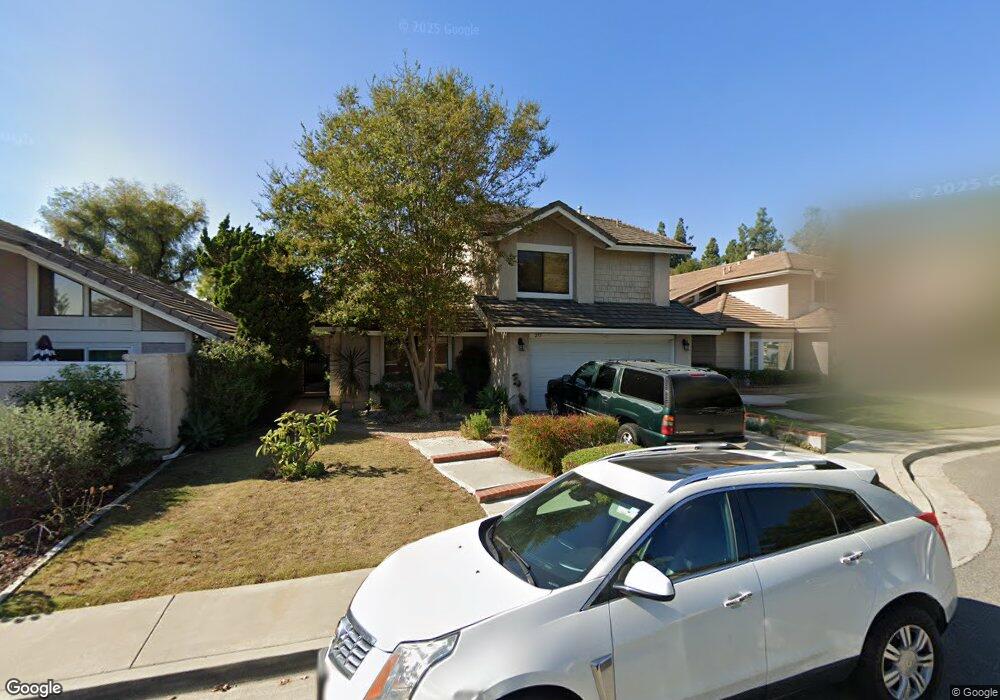
This home is located at 275 Cattail Cir, Brea, CA 92821 and is currently estimated at $1,148,212, approximately $552 per square foot. 275 Cattail Cir is a home located in Orange County with nearby schools including Brea Country Hills Elementary School, Brea Junior High School, and Brea-Olinda High School.
Ownership History
Date
Name
Owned For
Owner Type
Purchase Details
Closed on
Apr 5, 2004
Sold by
Forgette Thomas M and Forgette Christine D
Bought by
Forgette Thomas M and Forgette Christine D
Current Estimated Value
Home Financials for this Owner
Home Financials are based on the most recent Mortgage that was taken out on this home.
Original Mortgage
$172,000
Interest Rate
5.39%
Mortgage Type
New Conventional
Create a Home Valuation Report for This Property
The Home Valuation Report is an in-depth analysis detailing your home's value as well as a comparison with similar homes in the area
Home Values in the Area
Average Home Value in this Area
Purchase History
| Date | Buyer | Sale Price | Title Company |
|---|---|---|---|
| Forgette Thomas M | -- | Lawyers Title Co |
Source: Public Records
Mortgage History
| Date | Status | Borrower | Loan Amount |
|---|---|---|---|
| Closed | Forgette Thomas M | $172,000 |
Source: Public Records
Tax History
| Year | Tax Paid | Tax Assessment Tax Assessment Total Assessment is a certain percentage of the fair market value that is determined by local assessors to be the total taxable value of land and additions on the property. | Land | Improvement |
|---|---|---|---|---|
| 2025 | $5,690 | $499,099 | $250,639 | $248,460 |
| 2024 | $5,690 | $489,313 | $245,724 | $243,589 |
| 2023 | $5,532 | $479,719 | $240,906 | $238,813 |
| 2022 | $5,478 | $470,313 | $236,182 | $234,131 |
| 2021 | $5,374 | $461,092 | $231,551 | $229,541 |
| 2020 | $5,338 | $456,365 | $229,177 | $227,188 |
| 2019 | $5,195 | $447,417 | $224,683 | $222,734 |
| 2018 | $5,117 | $438,645 | $220,278 | $218,367 |
| 2017 | $5,020 | $430,045 | $215,959 | $214,086 |
| 2016 | $4,920 | $421,613 | $211,724 | $209,889 |
| 2015 | $4,851 | $415,280 | $208,543 | $206,737 |
| 2014 | $4,710 | $407,146 | $204,458 | $202,688 |
Source: Public Records
Map
Nearby Homes
- 136 Donnybrook Rd
- 570 Olive Ave
- 2304 Carrotwood Dr
- 688 Buttonwood Dr
- 2418 Rainbow Ln
- 2363 Morning Dew Dr
- 1796 Ravencrest Dr
- 360 Meadow Ct
- 2583 Sandpebble Ln
- 500 Silver Canyon Way
- 640 Cliffwood Ave
- 673 Cliffwood Ave
- 38 Rogers Ct
- 145 S Poplar Ave Unit 20
- 2761 E Stearns St
- 358 Trabuco Canyon Way
- 127 S Redwood Ave
- 878 N Landa Way
- 2851 Rolling Hills Dr Unit 178
- 2851 Rolling Hills Dr Unit 257
- 269 Cattail Cir
- 281 Cattail Cir
- 276 Heathcliff Place
- 287 Cattail Cir
- 282 Heathcliff Place
- 288 Heathcliff Place
- 293 Cattail Cir
- 274 Cattail Cir
- 268 Cattail Cir
- 280 Cattail Cir
- 294 Heathcliff Place
- 286 Cattail Cir
- 263 Singingwood Ln
- 292 Cattail Cir
- 1770 Cloverdale Dr
- 257 Singingwood Ln
- 1764 Cloverdale Dr
- 283 Creekwood Ct
- 283 Heathcliff Place
- 277 Creekwood Ct
Your Personal Tour Guide
Ask me questions while you tour the home.