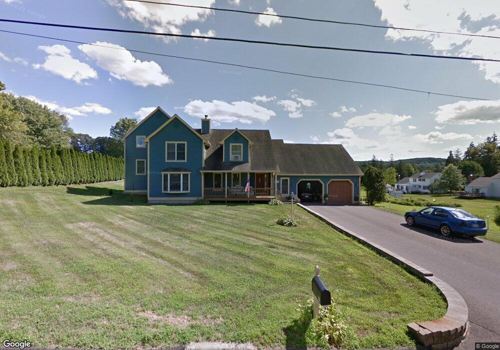
276 Prout Hill Rd Middletown, CT 06457
Estimated Value: $543,000 - $683,000
4
Beds
3
Baths
3,196
Sq Ft
$190/Sq Ft
Est. Value
About This Home
This home is located at 276 Prout Hill Rd, Middletown, CT 06457 and is currently estimated at $607,752, approximately $190 per square foot. 276 Prout Hill Rd is a home located in Middlesex County with nearby schools including Wesley School, Middletown High School, and St John Paul II School.
Ownership History
Date
Name
Owned For
Owner Type
Purchase Details
Closed on
Nov 22, 2024
Sold by
Passanisi Angelo S and Passanisi Linda P
Bought by
Passanisi T T and Passanisi P
Current Estimated Value
Create a Home Valuation Report for This Property
The Home Valuation Report is an in-depth analysis detailing your home's value as well as a comparison with similar homes in the area
Home Values in the Area
Average Home Value in this Area
Purchase History
| Date | Buyer | Sale Price | Title Company |
|---|---|---|---|
| Passanisi T T | -- | None Available | |
| Passanisi T T | -- | None Available |
Source: Public Records
Tax History
| Year | Tax Paid | Tax Assessment Tax Assessment Total Assessment is a certain percentage of the fair market value that is determined by local assessors to be the total taxable value of land and additions on the property. | Land | Improvement |
|---|---|---|---|---|
| 2025 | $12,196 | $329,530 | $72,920 | $256,610 |
| 2024 | $11,669 | $329,530 | $72,920 | $256,610 |
| 2023 | $11,076 | $329,530 | $72,920 | $256,610 |
| 2022 | $9,841 | $238,530 | $48,620 | $189,910 |
| 2021 | $9,797 | $238,530 | $48,620 | $189,910 |
| 2020 | $9,780 | $238,530 | $48,620 | $189,910 |
| 2019 | $9,828 | $238,530 | $48,620 | $189,910 |
| 2018 | $9,489 | $238,530 | $48,620 | $189,910 |
| 2017 | $8,598 | $222,290 | $59,410 | $162,880 |
| 2016 | $9,292 | $245,140 | $59,410 | $185,730 |
| 2015 | $8,240 | $222,290 | $59,410 | $162,880 |
| 2014 | $8,232 | $222,290 | $59,410 | $162,880 |
Source: Public Records
Map
Nearby Homes
- 909 Randolph Rd
- 50 Cedar St
- 63 Millbrook Rd
- Lot 3 Coleman Rd
- 122 Baldwin Dr
- 1 Jefferson Ave
- 7 Countryside Ln Unit 4
- 70 Jack English Dr
- 28 Kent Ct
- Lot 2 Coleman Rd
- 6 Hillside Ct
- 15 Blue Spruce St
- 58 Durant Terrace
- 7 Blue Bell Ln
- 180 Randolph Rd
- 6 Bidwell Terrace
- 3 Blue Bird Rd
- 42 Saybrook Rd
- 91 Gleeson Rd
- 5 Wall St
- 288 Prout Hill Rd
- 266 Prout Hill Rd
- 220 Margarite Rd
- 279 Prout Hill Rd
- 274 Prout Hill Rd
- 285 Prout Hill Rd
- 236 Margarite Rd
- 192 Margarite Rd
- 144 Mcdowell Rd
- 248 Prout Hill Rd
- 251 Prout Hill Rd
- 272 Prout Hill Rd
- 143 Mcdowell Rd
- 6R Prout Hill Rd
- 6 Prout Hill Rd
- 178 Margarite Rd
- 219 Margarite Rd
- 209 Margarite Rd
- 240 Prout Hill Rd
- 241 Prout Hill Rd
Your Personal Tour Guide
Ask me questions while you tour the home.