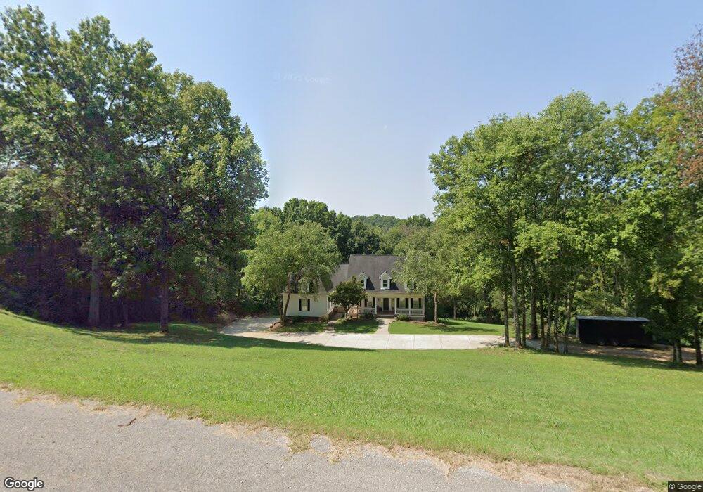
2763 Broyles Ln Franklin, TN 37069
Estimated Value: $1,558,998 - $1,801,000
--
Bed
6
Baths
4,135
Sq Ft
$407/Sq Ft
Est. Value
About This Home
This home is located at 2763 Broyles Ln, Franklin, TN 37069 and is currently estimated at $1,682,750, approximately $406 per square foot. 2763 Broyles Ln is a home located in Williamson County with nearby schools including Grassland Elementary School, Grassland Middle School, and Franklin High School.
Ownership History
Date
Name
Owned For
Owner Type
Purchase Details
Closed on
Jul 30, 1999
Sold by
Anderson Spencer R and Anderson Jacquelyn G
Bought by
Grasso Donald D and Grasso Cynthia J
Current Estimated Value
Home Financials for this Owner
Home Financials are based on the most recent Mortgage that was taken out on this home.
Original Mortgage
$468,000
Outstanding Balance
$131,547
Interest Rate
7.37%
Estimated Equity
$1,551,203
Create a Home Valuation Report for This Property
The Home Valuation Report is an in-depth analysis detailing your home's value as well as a comparison with similar homes in the area
Home Values in the Area
Average Home Value in this Area
Purchase History
| Date | Buyer | Sale Price | Title Company |
|---|---|---|---|
| Grasso Donald D | $585,000 | -- |
Source: Public Records
Mortgage History
| Date | Status | Borrower | Loan Amount |
|---|---|---|---|
| Open | Grasso Donald D | $468,000 | |
| Closed | Grasso Donald D | $58,500 |
Source: Public Records
Tax History Compared to Growth
Tax History
| Year | Tax Paid | Tax Assessment Tax Assessment Total Assessment is a certain percentage of the fair market value that is determined by local assessors to be the total taxable value of land and additions on the property. | Land | Improvement |
|---|---|---|---|---|
| 2025 | $4,622 | $388,075 | $196,050 | $192,025 |
| 2024 | $4,622 | $245,875 | $85,575 | $160,300 |
| 2023 | $4,622 | $245,875 | $85,575 | $160,300 |
| 2022 | $4,622 | $245,875 | $85,575 | $160,300 |
| 2021 | $4,622 | $245,875 | $85,575 | $160,300 |
| 2020 | $4,721 | $212,675 | $57,775 | $154,900 |
| 2019 | $4,721 | $212,675 | $57,775 | $154,900 |
| 2018 | $4,573 | $212,675 | $57,775 | $154,900 |
| 2017 | $4,573 | $212,675 | $57,775 | $154,900 |
| 2016 | $4,573 | $212,675 | $57,775 | $154,900 |
| 2015 | -- | $183,450 | $49,800 | $133,650 |
| 2014 | -- | $183,450 | $49,800 | $133,650 |
Source: Public Records
Map
Nearby Homes
- 896 Sneed Rd W
- 161 Saint Andrews Dr
- 543 Trace Creek Dr
- 123 Saint Andrews Dr
- 5720 Templegate Dr
- 5728 Templegate Dr
- 6211 Temple Rd
- 7867 Highway 100
- 7950 Highway 100
- 7910 Highway 100
- 8039 Tennessee 100
- 5621 Traceside Dr
- 949 Harpeth Bend Dr
- 360 Vaughn Rd
- 805 Silkwood Dr Unit 3
- 815 Silkwood Dr
- 7816 Old Harding Pike
- 159 N Berwick Ln
- 7313 Olmsted Dr
- 2746 Rock Wall Rd
- 2768 Broyles Ln
- 2727 Broyles Ln
- 2755 Broyles Ln
- 2762 Broyles Ln
- 2776 Broyles Ln
- 806 Sneed Rd W
- 2719 Broyles Ln
- 2758 Broyles Ln
- 2713 Broyles Ln
- 814 Sneed Rd W
- 2756 Broyles Ln
- 812 Sneed Rd W
- 1108 David Dr
- 1110 David Dr
- 1106 David Dr
- 1104 David Dr
- 2732 Broyles Ln
- 2724 Broyles Ln
- 2750 Broyles Ln
- 1102 David Dr