
Seller's Agent in 2025
Cindy Wilson
RED Realty
(314) 239-8649
2 in this area
94 Total Sales

Estimated Value: $307,000 - $315,011
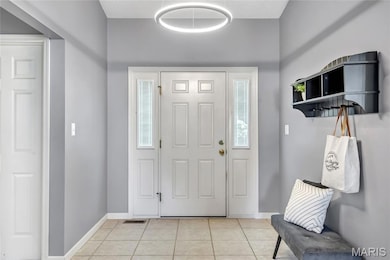
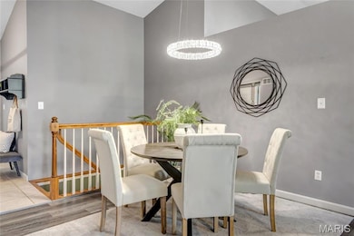
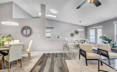
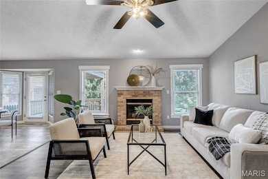
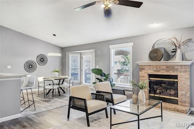
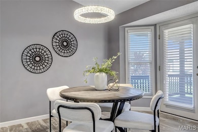
Step into this open floor plan ranch villa with all you need on the main floor and then MORE in the finished walk out basement! Needing a bit of TLC, this 3-bedrooms, 3 full baths has over 2400 square feet living space! Seller has taken the time to help make your transition to call this house home seamless! 7 yr young HVAC, 1.5 yr young water heater, 2-year young luxury vinyl plank flooring, plus new lighting fixtures! Step into the large ceramic tiled entry foyer and the vaulted great room greats you with lots of natural lighting! Warm, decorative gas fireplace is flanked by 5' windows on each side. Lots of options to choose from for dining locations! Dining Room! Breakfast Room! Breakfast Bar! Plus, you'll enjoy your mornings with the quiet view from the large 17'x11' covered deck with attractive palm leaf blades! Large, vaulted master bedroom with walk in closet, soaking tub, separate shower, double sink vanity and gentlemen's height commode. Kitchen with natural light from the vaulted skylight, along with a large, deep ss double sink, roll out drawers, 5 burner gas stove, lazy susan, pan cabinet and side by side refrigerator with ice/water dispenser and deep freezer drawer that stays! Main floor laundry room with nicely sized closet! The walk out basement hosts a theater room with theater seating that stays and provides a wet bar for additional entertainment options! 3rd bedroom in finished lower level, along with a full bathroom and ample storage with built in shelving and workbench. Garage is drywalled and has a garage keypad as an additional entry. All flat screen tv's stay with home! Stop by today!
| Date | Buyer | Sale Price | Title Company |
|---|---|---|---|
| Westcott Gregory C | -- | Investors Title | |
| Salter Tracee | -- | None Listed On Document | |
| Salter Tracee | -- | Freedom Title | |
| Salter Tracee | -- | None Listed On Document | |
| Boxdorfer William R | $206,000 | Ort |
| Date | Status | Borrower | Loan Amount |
|---|---|---|---|
| Previous Owner | Salter Tracee | $161,000 | |
| Previous Owner | Boxdorfer William R | $206,000 |
| Date | Event | Price | List to Sale | Price per Sq Ft |
|---|---|---|---|---|
| 12/19/2025 12/19/25 | Sold | -- | -- | -- |
| 11/15/2025 11/15/25 | Pending | -- | -- | -- |
| 11/05/2025 11/05/25 | Price Changed | $315,000 | -3.1% | $124 / Sq Ft |
| 10/26/2025 10/26/25 | For Sale | $325,000 | -- | $128 / Sq Ft |
| Year | Tax Paid | Tax Assessment Tax Assessment Total Assessment is a certain percentage of the fair market value that is determined by local assessors to be the total taxable value of land and additions on the property. | Land | Improvement |
|---|---|---|---|---|
| 2025 | $3,598 | $63,343 | -- | -- |
| 2023 | $3,596 | $57,690 | -- | -- |
| 2022 | $3,304 | $49,279 | $0 | $0 |
| 2021 | $3,302 | $49,279 | $0 | $0 |
| 2020 | $2,852 | $41,084 | $0 | $0 |
| 2019 | $2,843 | $41,084 | $0 | $0 |
| 2018 | $2,929 | $40,512 | $0 | $0 |
| 2017 | $2,914 | $40,512 | $0 | $0 |
| 2016 | $2,709 | $37,537 | $0 | $0 |
| 2015 | $2,487 | $37,537 | $0 | $0 |
| 2014 | $2,079 | $30,624 | $0 | $0 |
Seller's Agent in 2025
Cindy Wilson
RED Realty
(314) 239-8649
2 in this area
94 Total Sales
K
Seller Co-Listing Agent in 2025
Karyn Fields
RED Realty
(314) 973-3396
1 in this area
2 Total Sales
Buyer's Agent in 2025
Alicia Page
DRG - Delhougne Realty Group
(636) 544-7093
2 in this area
48 Total Sales
Source: MARIS MLS
MLS Number: MIS25070012
APN: 2-113B-9170-00-735B.0000000
Disclaimer: Certain information contained herein is derived from information provided by parties other than Homes.com. All information provided is deemed reliable, but is not guaranteed to be accurate and should be independently verified.
![]() Based on information submitted to the MLS GRID. All data is obtained from various sources and may not have been verified by broker or MLS GRID. Supplied Open House Information is subject to change without notice. All information should be independently reviewed and verified for accuracy. Properties may or may not be listed by the office/agent presenting the information. Some IDX listings have been excluded from this website.
Based on information submitted to the MLS GRID. All data is obtained from various sources and may not have been verified by broker or MLS GRID. Supplied Open House Information is subject to change without notice. All information should be independently reviewed and verified for accuracy. Properties may or may not be listed by the office/agent presenting the information. Some IDX listings have been excluded from this website.
Based on information submitted to the MLS GRID
Ask me questions while you tour the home.