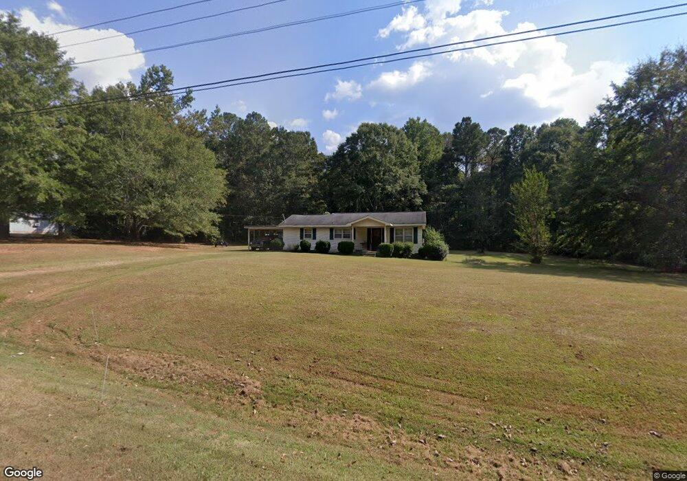
277 Laurel Rd Carrollton, GA 30117
Estimated Value: $221,572 - $274,000
2
Beds
1
Bath
1,310
Sq Ft
$198/Sq Ft
Est. Value
About This Home
This home is located at 277 Laurel Rd, Carrollton, GA 30117 and is currently estimated at $259,143, approximately $197 per square foot. 277 Laurel Rd is a home located in Carroll County with nearby schools including Central Elementary School, Central Middle School, and Central High School.
Ownership History
Date
Name
Owned For
Owner Type
Purchase Details
Closed on
May 24, 2004
Sold by
Morrow Richard Est
Bought by
Morrow Timothy R and Gable Kimberly M
Current Estimated Value
Purchase Details
Closed on
May 3, 2004
Sold by
Morrow Sandra M
Bought by
Morrow Timothy R and Gable Kimberly M
Purchase Details
Closed on
May 23, 1995
Bought by
Morrow Richard
Purchase Details
Closed on
Feb 1, 1990
Bought by
Morrow
Purchase Details
Closed on
Oct 1, 1972
Bought by
Morrow
Purchase Details
Closed on
Jan 1, 1969
Bought by
Morrow
Create a Home Valuation Report for This Property
The Home Valuation Report is an in-depth analysis detailing your home's value as well as a comparison with similar homes in the area
Home Values in the Area
Average Home Value in this Area
Purchase History
| Date | Buyer | Sale Price | Title Company |
|---|---|---|---|
| Morrow Timothy R | -- | -- | |
| Morrow Timothy R | -- | -- | |
| Morrow Timothy R | -- | -- | |
| Morrow Timothy R | -- | -- | |
| Morrow Richard | -- | -- | |
| Morrow | -- | -- | |
| Morrow | -- | -- | |
| Morrow | -- | -- |
Source: Public Records
Tax History Compared to Growth
Tax History
| Year | Tax Paid | Tax Assessment Tax Assessment Total Assessment is a certain percentage of the fair market value that is determined by local assessors to be the total taxable value of land and additions on the property. | Land | Improvement |
|---|---|---|---|---|
| 2024 | $1,319 | $77,075 | $41,950 | $35,125 |
| 2023 | $1,319 | $65,554 | $33,560 | $31,994 |
| 2022 | $928 | $48,088 | $22,374 | $25,714 |
| 2021 | $809 | $40,190 | $17,899 | $22,291 |
| 2020 | $738 | $36,213 | $16,272 | $19,941 |
| 2019 | $717 | $34,824 | $16,272 | $18,552 |
| 2018 | $611 | $28,490 | $11,498 | $16,992 |
| 2017 | $613 | $28,490 | $11,498 | $16,992 |
| 2016 | $584 | $34,466 | $11,498 | $22,968 |
| 2015 | $570 | $24,374 | $12,951 | $11,424 |
| 2014 | $572 | $24,375 | $12,951 | $11,424 |
Source: Public Records
Map
Nearby Homes
- 1531 Tyus Carrollton Rd
- 105 Woodbine Dr
- 345 Piney Grove Rd
- 915 Oak Grove Rd
- 399 Old Camp Church Rd
- 0 Buffalo Creek Rd Unit 10624169
- 533 Buffalo Creek Rd
- 20 Camp Ct
- 0 Bonner Rd Unit 10635754
- 95 Camp Ln
- 195 Gold Dust Trail
- 450 Baxter Rd
- 21 Crabapple Place
- The Coleman Plan at Summerfield Place
- The Pearson Plan at Summerfield Place
- The Piedmont Plan at Summerfield Place
- The Harrington Plan at Summerfield Place
- The McGinnis Plan at Summerfield Place
- The Telfair Plan at Summerfield Place
- 1585 Hays Mill Rd
- 297 Laurel Rd
- 288 Laurel Rd
- 302 Laurel Rd
- 327 Laurel Rd
- 315 Briarwood Ln
- 211 Laurel Rd
- 345 Laurel Rd
- 381 Laurel Rd
- 73 Briarwood Ln
- 340 Laurel Rd
- 361 Laurel Rd
- 383 Laurel Rd
- 178 Laurel Rd
- 150 Tammy Ln
- 158 S Walker Lake Dr
- 155 S Walker Lake Dr
- 429 Laurel Rd
- S S Walker Lake Dr
- 150 S Walker Lake Dr
- 140 Tammy Ln