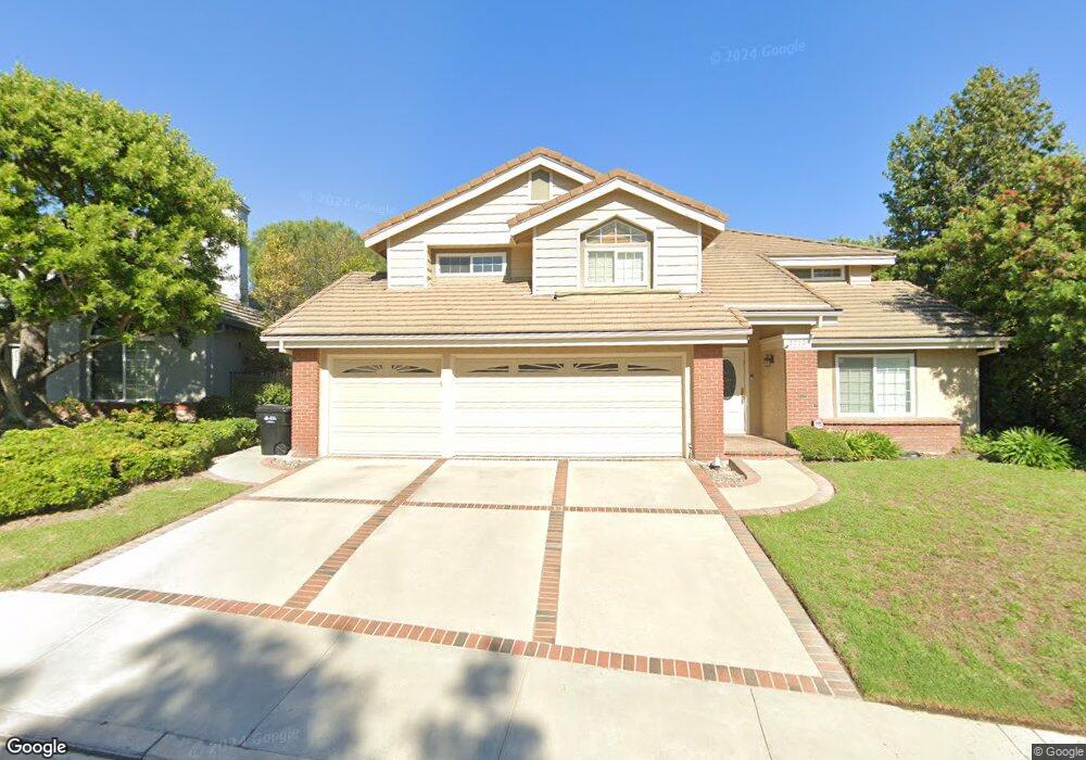
2772 Jason Ct Thousand Oaks, CA 91362
Estimated Value: $1,354,000 - $1,420,000
4
Beds
3
Baths
2,669
Sq Ft
$514/Sq Ft
Est. Value
About This Home
This home is located at 2772 Jason Ct, Thousand Oaks, CA 91362 and is currently estimated at $1,371,358, approximately $513 per square foot. 2772 Jason Ct is a home located in Ventura County with nearby schools including Lang Ranch, Los Cerritos Middle School, and Westlake High School.
Ownership History
Date
Name
Owned For
Owner Type
Purchase Details
Closed on
Sep 15, 2002
Sold by
Piperi John and Piperi Sherry
Bought by
Gubner Gregory Darrin and Gubner Eydie Jill
Current Estimated Value
Home Financials for this Owner
Home Financials are based on the most recent Mortgage that was taken out on this home.
Original Mortgage
$512,000
Interest Rate
5.87%
Create a Home Valuation Report for This Property
The Home Valuation Report is an in-depth analysis detailing your home's value as well as a comparison with similar homes in the area
Purchase History
| Date | Buyer | Sale Price | Title Company |
|---|---|---|---|
| Gubner Gregory Darrin | $640,000 | Fidelity National Title Co |
Source: Public Records
Mortgage History
| Date | Status | Borrower | Loan Amount |
|---|---|---|---|
| Previous Owner | Gubner Gregory Darrin | $512,000 |
Source: Public Records
Tax History
| Year | Tax Paid | Tax Assessment Tax Assessment Total Assessment is a certain percentage of the fair market value that is determined by local assessors to be the total taxable value of land and additions on the property. | Land | Improvement |
|---|---|---|---|---|
| 2025 | $10,411 | $926,913 | $370,761 | $556,152 |
| 2024 | $10,411 | $908,739 | $363,491 | $545,248 |
| 2023 | $10,117 | $890,921 | $356,364 | $534,557 |
| 2022 | $9,925 | $873,452 | $349,376 | $524,076 |
| 2021 | $9,738 | $856,326 | $342,526 | $513,800 |
| 2020 | $9,252 | $847,548 | $339,015 | $508,533 |
| 2019 | $9,006 | $830,930 | $332,368 | $498,562 |
| 2018 | $8,820 | $814,638 | $325,851 | $488,787 |
| 2017 | $8,644 | $798,665 | $319,462 | $479,203 |
| 2016 | $8,557 | $783,006 | $313,199 | $469,807 |
| 2015 | $8,404 | $771,247 | $308,496 | $462,751 |
| 2014 | $8,067 | $736,000 | $295,000 | $441,000 |
Source: Public Records
Map
Nearby Homes
- 2181 Brookfield Dr
- 2280 Meadowside Dr
- 2596 Rikkard Dr
- 2649 Rikkard Dr
- 1915 Woodside Dr
- 2283 Northpark St
- 2845 Queens Way
- 3182 Toulouse Cir
- 3225 Futura Point
- 2397 Laurelpark Ct
- 2749 Amber Wood Place
- 2202 Aspenpark Ct
- 2457 Rutland Place
- 2161 Scenicpark St
- 2654 Whitechapel Place
- 2225 Calle Riscoso
- 1638 Sweet Briar Place
- 2201 Sonoma Ct
- 3434 Fayance Place
- 1762 Tiburon Ct
- 2760 Jason Ct
- 2874 Jason Ct
- 2803 Hilary Ct
- 2748 Jason Ct
- 2796 Jason Ct
- 2783 Jason Ct
- 2791 Hilary Ct
- 2815 Hilary Ct
- 2109 Brookfield Dr
- 2145 Brookfield Dr
- 2736 Jason Ct
- 2808 Jason Ct
- 2779 Hilary Ct
- 2795 Jason Ct
- 2097 Brookfield Dr
- 2157 Brookfield Dr
- 2816 Hilary Ct
- 2820 Jason Ct
- 2822 Jason Ct
- 2767 Hilary Ct
Your Personal Tour Guide
Ask me questions while you tour the home.