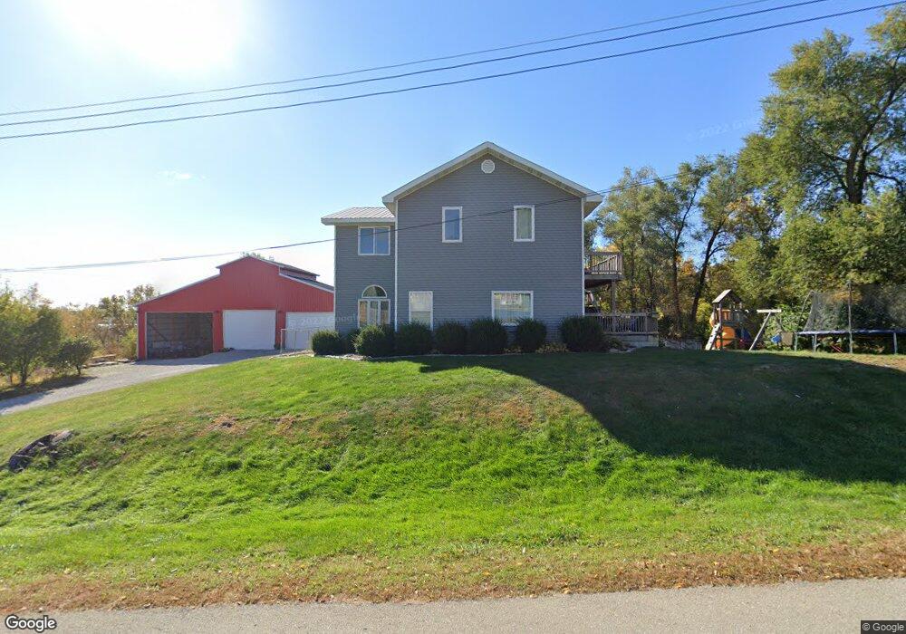
2779 S 12th Ave W Newton, IA 50208
Estimated Value: $342,000 - $441,000
3
Beds
1
Bath
3,264
Sq Ft
$122/Sq Ft
Est. Value
About This Home
This home is located at 2779 S 12th Ave W, Newton, IA 50208 and is currently estimated at $396,682, approximately $121 per square foot. 2779 S 12th Ave W is a home located in Jasper County with nearby schools including Thomas Jefferson Elementary School, Woodrow Wilson Elementary School, and Berg Middle School.
Ownership History
Date
Name
Owned For
Owner Type
Purchase Details
Closed on
Apr 16, 2014
Sold by
Decker T J and Decker Rebecca P
Bought by
Decker Todd J and Decker Rebecca P
Current Estimated Value
Home Financials for this Owner
Home Financials are based on the most recent Mortgage that was taken out on this home.
Original Mortgage
$82,000
Outstanding Balance
$62,265
Interest Rate
4.31%
Mortgage Type
New Conventional
Estimated Equity
$334,417
Purchase Details
Closed on
May 29, 2008
Sold by
Lasalle Bank Na
Bought by
Decker T J
Home Financials for this Owner
Home Financials are based on the most recent Mortgage that was taken out on this home.
Original Mortgage
$60,000
Interest Rate
6.1%
Mortgage Type
Construction
Create a Home Valuation Report for This Property
The Home Valuation Report is an in-depth analysis detailing your home's value as well as a comparison with similar homes in the area
Home Values in the Area
Average Home Value in this Area
Purchase History
| Date | Buyer | Sale Price | Title Company |
|---|---|---|---|
| Decker Todd J | -- | None Available | |
| Decker T J | $40,000 | None Available | |
| Lasalle Bank Na | -- | None Available |
Source: Public Records
Mortgage History
| Date | Status | Borrower | Loan Amount |
|---|---|---|---|
| Open | Decker Todd J | $82,000 | |
| Previous Owner | Lasalle Bank Na | $60,000 |
Source: Public Records
Tax History Compared to Growth
Tax History
| Year | Tax Paid | Tax Assessment Tax Assessment Total Assessment is a certain percentage of the fair market value that is determined by local assessors to be the total taxable value of land and additions on the property. | Land | Improvement |
|---|---|---|---|---|
| 2025 | $3,546 | $372,900 | $76,000 | $296,900 |
| 2024 | $3,546 | $279,080 | $48,400 | $230,680 |
| 2023 | $3,434 | $279,080 | $48,400 | $230,680 |
| 2022 | $2,904 | $211,960 | $48,400 | $163,560 |
| 2021 | $2,630 | $202,460 | $48,400 | $154,060 |
| 2020 | $2,630 | $174,950 | $33,080 | $141,870 |
| 2019 | $2,058 | $130,520 | $0 | $0 |
| 2018 | $2,058 | $130,520 | $0 | $0 |
| 2017 | $2,062 | $130,520 | $0 | $0 |
| 2016 | $2,062 | $127,650 | $0 | $0 |
| 2015 | $1,958 | $124,530 | $0 | $0 |
| 2014 | $1,872 | $124,530 | $0 | $0 |
Source: Public Records
Map
Nearby Homes
- 860 W 28th St S
- TBD W 28th St S
- 1149 W 28th St S
- 913 W 18th St S
- 1401 W 16th St S Unit 2
- 1506 W 17th St S
- 1503 S 16th Ave W
- 1506 W 14th St S
- 6911-10 Highway F 48 W
- 1321 W 13th St S
- 1431 Cardinal Ridge Dr
- 299 Hickory St
- 2214 Highway F48 W
- 2125 W 15th St S
- 124 Emerson Hough Dr
- 1207 S 16th Ave W
- 1121 Woodland Dr
- 1202 S 20th Ave W
- 210 W 13th St S
- 1221 Monroe Dr
- Lot 2 W 28th St S
- Lot 1 W 28th St S
- 1172 W 28th St S
- 1124 W 28th St S
- 1084 W 28th St S
- 1021 W 28th St S Unit A
- 1021 W 28th St S
- 2900 S 12th Ave W Unit 1
- 2900 S 12th Ave W Unit 2
- 2900 S 12th Ave W Unit 3
- 2900 S 12th Ave W Unit 4
- 2900 S 12th Ave W Unit 5
- 2900 S 12th Ave W
- 2900 S 12th Ave W
- 1276 W 29th St S
- 978 W 28th St S
- 3118 Harbor Ave
- 3226 Harbor Ave
- 873 W 28th St S
- 3318 Harbor Ave