
Seller's Agent in 2025
Susan Muther
Keller Williams Upstate NY Properties
(607) 435-0470
3 in this area
183 Total Sales

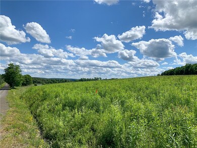
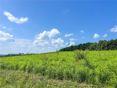
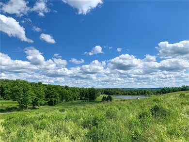
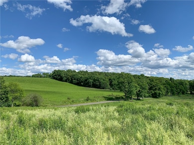
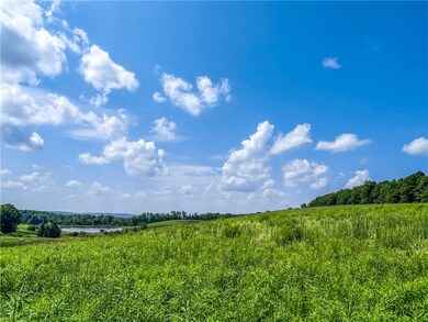
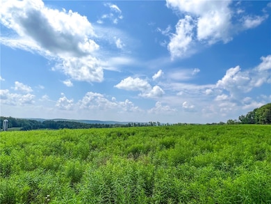
This lovely 5+ ac lot was originally part of the Long View Farm subdivision, and oh how true that name is. The partially wooded lot has a near perfect building site with that long range view on the front acreage. Kersmanc Rd is town maintained, and there is a new culvert pipe and driveway started to enter the lot from the road. The land was part of a classic dairy farm with a mix of open fields, and standing hardwood forests in the rolling hills of the Maple Valley near Cooperstown. Less than a mile to the 3,500 acre Bear Swamp State Forest with a 14+ mile marked trail system (cross-country skiing, hiking, horseback riding and mt. biking). There are 12+ miles of snowmobile trails in Bear Swamp State Forest, which include 2.5 mi. of corridor trail and the 10 mi. Bear Swamp/Ridge Rd loop trail. A large wetland and creek bisect the forest and provide excellent opportunities for those who love to paddle. (R. Milton Hick State Forest, Maple Valley State Forest, and Decatur State Forest are also nearby.) This lot, with 340+ feet of road frontage, would make an appealing setting for your perfect home (deed restriction preventing single-wide homes). A private well can be dug without having to get an additional permit. Minutes to Cooperstown, under an hour from Oneonta, and 75 miles to Albany International Airport.
Last Agent to Sell the Property
Listing by Keller Williams Upstate NY Properties Brokerage Phone: (607) 435-0470 License #10401290369 Listed on: 05/28/2025
Co-Listed By
Listing by Keller Williams Upstate NY Properties Brokerage Phone: (607) 435-0470 License #10401296752
Last Buyer's Agent
Listing by Keller Williams Upstate NY Properties Brokerage Phone: (607) 435-0470 License #10401290369 Listed on: 05/28/2025
| Date | Type | Sale Price | Title Company |
|---|---|---|---|
| Warranty Deed | $27,000 | None Available |
| Date | Event | Price | Change | Sq Ft Price |
|---|---|---|---|---|
| 09/03/2025 09/03/25 | Sold | $33,000 | 0.0% | -- |
| 07/02/2025 07/02/25 | Pending | -- | -- | -- |
| 05/28/2025 05/28/25 | For Sale | $33,000 | -- | -- |
| Year | Tax Paid | Tax Assessment Tax Assessment Total Assessment is a certain percentage of the fair market value that is determined by local assessors to be the total taxable value of land and additions on the property. | Land | Improvement |
|---|---|---|---|---|
| 2024 | $407 | $5,750 | $5,750 | $0 |
| 2023 | $0 | $5,750 | $5,750 | $0 |
| 2022 | -- | $5,750 | $5,750 | $0 |
| 2021 | $0 | $5,750 | $5,750 | $0 |
| 2020 | -- | $5,750 | $5,750 | $0 |
Seller's Agent in 2025
Susan Muther
Keller Williams Upstate NY Properties
(607) 435-0470
3 in this area
183 Total Sales
H
Seller Co-Listing Agent in 2025
Hazen Reed
Keller Williams Upstate NY Properties
(607) 435-0736
2 in this area
95 Total Sales
Source: Otsego-Delaware Board of REALTORS®
MLS Number: R1608842
APN: 362600 136.00-2-2.05
Disclaimer: Certain information contained herein is derived from information provided by parties other than Homes.com. All information provided is deemed reliable, but is not guaranteed to be accurate and should be independently verified.
![]() The data relating to real estate on this web site comes in part from the Internet Data Exchange (IDX) Program of the CNYIS, UNYREIS and WNYREIS. Real estate listings held by firms other than Homes.com, LLC are marked with the IDX logo and include the Listing Broker’s Firm Name.
The data relating to real estate on this web site comes in part from the Internet Data Exchange (IDX) Program of the CNYIS, UNYREIS and WNYREIS. Real estate listings held by firms other than Homes.com, LLC are marked with the IDX logo and include the Listing Broker’s Firm Name.
Disclaimer: All information deemed reliable but not guaranteed and should be independently verified. All properties are subject to prior sale, change or withdrawal. Neither the listing broker(s) nor Homes.com, LLC shall be responsible for any typographical errors, misinformation, misprints, and shall be held totally harmless. © 2025 CNYIS, UNYREIS, WNYREIS. All rights reserved.