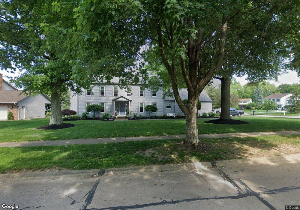
279 Pheasant Run Wadsworth, OH 44281
Estimated Value: $352,137 - $441,000
4
Beds
3
Baths
2,856
Sq Ft
$139/Sq Ft
Est. Value
About This Home
This home is located at 279 Pheasant Run, Wadsworth, OH 44281 and is currently estimated at $397,784, approximately $139 per square foot. 279 Pheasant Run is a home located in Medina County with nearby schools including Overlook Elementary School, Wadsworth Middle School, and Central Intermediate School.
Ownership History
Date
Name
Owned For
Owner Type
Purchase Details
Closed on
Aug 6, 2012
Sold by
Laws James M and Laws Patricia A
Bought by
Laws Patricia A
Current Estimated Value
Home Financials for this Owner
Home Financials are based on the most recent Mortgage that was taken out on this home.
Original Mortgage
$166,900
Outstanding Balance
$97,431
Interest Rate
3.65%
Mortgage Type
Future Advance Clause Open End Mortgage
Estimated Equity
$300,353
Purchase Details
Closed on
Jul 8, 2012
Sold by
Laws James W
Bought by
Laws Patricia A
Home Financials for this Owner
Home Financials are based on the most recent Mortgage that was taken out on this home.
Original Mortgage
$166,900
Outstanding Balance
$97,431
Interest Rate
3.65%
Mortgage Type
Future Advance Clause Open End Mortgage
Estimated Equity
$300,353
Purchase Details
Closed on
Jul 24, 2006
Sold by
Mitchell David J and Mitchell Virginia L
Bought by
Laws James M
Create a Home Valuation Report for This Property
The Home Valuation Report is an in-depth analysis detailing your home's value as well as a comparison with similar homes in the area
Home Values in the Area
Average Home Value in this Area
Purchase History
| Date | Buyer | Sale Price | Title Company |
|---|---|---|---|
| Laws Patricia A | -- | -- | |
| Laws Patricia A | -- | None Available | |
| Laws James M | $222,000 | -- |
Source: Public Records
Mortgage History
| Date | Status | Borrower | Loan Amount |
|---|---|---|---|
| Open | Laws Patricia A | $166,900 |
Source: Public Records
Tax History Compared to Growth
Tax History
| Year | Tax Paid | Tax Assessment Tax Assessment Total Assessment is a certain percentage of the fair market value that is determined by local assessors to be the total taxable value of land and additions on the property. | Land | Improvement |
|---|---|---|---|---|
| 2024 | $3,837 | $87,390 | $22,750 | $64,640 |
| 2023 | $3,837 | $87,390 | $22,750 | $64,640 |
| 2022 | $3,849 | $87,390 | $22,750 | $64,640 |
| 2021 | $3,636 | $69,910 | $18,200 | $51,710 |
| 2020 | $3,202 | $69,910 | $18,200 | $51,710 |
| 2019 | $3,207 | $69,910 | $18,200 | $51,710 |
| 2018 | $3,013 | $61,610 | $17,610 | $44,000 |
| 2017 | $3,014 | $61,610 | $17,610 | $44,000 |
| 2016 | $3,064 | $61,610 | $17,610 | $44,000 |
| 2015 | $2,965 | $56,510 | $16,150 | $40,360 |
| 2014 | $3,014 | $56,510 | $16,150 | $40,360 |
| 2013 | $3,018 | $56,510 | $16,150 | $40,360 |
Source: Public Records
Map
Nearby Homes
- 264 Windfall Ln
- 765 Broad St
- 493 Broad St Unit 495
- 637 Bent Creek Dr
- 178 Fairlawn Ave
- 684 Akron Rd
- 440 Dohner Dr
- 273 E Boyer St
- 141 Humbolt Ave
- 105 Barkwood Dr
- 137 Bay Hill Dr
- 878 Longbrook Dr
- 957 Devonwood Dr Unit 15
- 352 N Lyman St
- 411 Treeview Dr
- 118 E Prospect St
- 235 High St
- 0 Greenwich Rd
- 362 Silver Meadow Dr
- 140 W North St
- 634 Tanbark Ln
- 299 Pheasant Run
- 633 Tamarac Trail
- 259 Pheasant Run
- 280 Pheasant Run
- 270 Pheasant Run
- 642 Tanbark Ln
- 290 Pheasant Run
- 643 Tamarac Trail
- 260 Pheasant Run
- 668 Tanbark Ln
- 650 Tanbark Ln
- 658 Tanbark Ln
- 300 Pheasant Run
- 624 Tamarac Trail
- 245 Pheasant Run
- 610 Fixler Dr
- 653 Tamarac Trail
- 310 Pheasant Run
- 285 High Point Dr