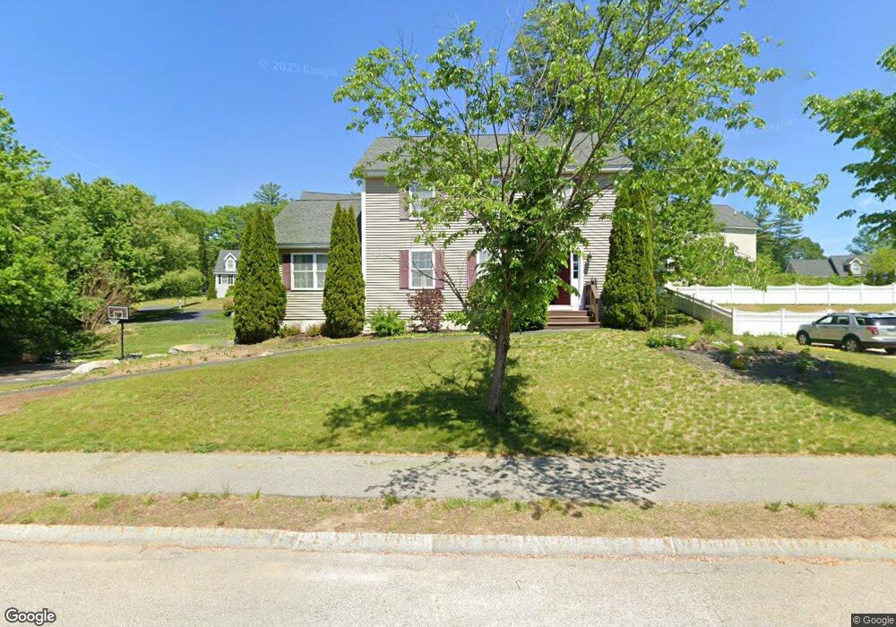
28 Hawthorne Cir Somersworth, NH 03878
Estimated Value: $530,621 - $566,000
3
Beds
3
Baths
2,000
Sq Ft
$274/Sq Ft
Est. Value
About This Home
This home is located at 28 Hawthorne Cir, Somersworth, NH 03878 and is currently estimated at $547,405, approximately $273 per square foot. 28 Hawthorne Cir is a home with nearby schools including Maple Wood Elementary School, Somersworth High School, and Tri-City Christian Academy.
Ownership History
Date
Name
Owned For
Owner Type
Purchase Details
Closed on
Oct 30, 2009
Sold by
Gerrish Park Llc
Bought by
Doyle John F and Doyle Marisol A
Current Estimated Value
Home Financials for this Owner
Home Financials are based on the most recent Mortgage that was taken out on this home.
Original Mortgage
$216,000
Outstanding Balance
$140,327
Interest Rate
5.06%
Mortgage Type
Purchase Money Mortgage
Estimated Equity
$407,078
Create a Home Valuation Report for This Property
The Home Valuation Report is an in-depth analysis detailing your home's value as well as a comparison with similar homes in the area
Home Values in the Area
Average Home Value in this Area
Purchase History
| Date | Buyer | Sale Price | Title Company |
|---|---|---|---|
| Doyle John F | $240,000 | -- |
Source: Public Records
Mortgage History
| Date | Status | Borrower | Loan Amount |
|---|---|---|---|
| Open | Doyle John F | $216,000 |
Source: Public Records
Tax History Compared to Growth
Tax History
| Year | Tax Paid | Tax Assessment Tax Assessment Total Assessment is a certain percentage of the fair market value that is determined by local assessors to be the total taxable value of land and additions on the property. | Land | Improvement |
|---|---|---|---|---|
| 2024 | $8,987 | $480,600 | $98,800 | $381,800 |
| 2023 | $7,829 | $267,200 | $37,000 | $230,200 |
| 2022 | $7,506 | $267,200 | $37,000 | $230,200 |
| 2021 | $7,356 | $267,200 | $37,000 | $230,200 |
| 2020 | $7,442 | $267,200 | $37,000 | $230,200 |
| 2019 | $7,292 | $267,300 | $37,000 | $230,300 |
| 2018 | $7,648 | $228,900 | $47,300 | $181,600 |
| 2017 | $7,574 | $228,900 | $47,300 | $181,600 |
| 2016 | $7,352 | $228,900 | $47,300 | $181,600 |
| 2015 | $7,472 | $231,700 | $47,300 | $184,400 |
| 2014 | $7,215 | $231,700 | $47,300 | $184,400 |
Source: Public Records
Map
Nearby Homes
- 159 W High St
- 43 Otis Rd
- 395 Route 108
- 203 New Hampshire 108
- 94 Maple St Unit A
- 45 Crystal Springs Way
- 18 Lenox Dr Unit C
- 38 Laurel Ln
- 29 Chadwick Ln
- 163 Rochester St
- 301 Sherwood Glen
- 200 Sherwood Glen
- 229 Sherwood Glen
- 206 Sherwood Glen
- 13 Guy St
- 19B Birch Hill Ln Unit 19B
- 23A Birch Hill Ln Unit 23A
- 23B Birch Hill Ln Unit 23B
- 22A Birch Hill Ln Unit 22A
- 19A Birch Hill Ln Unit 19A
- 70 Hawthorne Cir
- 32 Hawthorne Cir
- 64 Hawthorne Cir
- 29 Hawthorne Cir
- 29 Hawthorne Cir
- 33 Hawthorne Cir
- 24 Hawthorne Cir
- 25 Hawthorne Cir
- 67 Hawthorne Cir
- 35 Hawthorne Cir
- 73 Hawthorne Cir
- 56 Hawthorne Cir
- 38 Hawthorne Cir
- 65 Hawthorne Cir
- 77 Hawthorne Cir
- 39 Hawthorne Cir
- 61 Hawthorne Cir
- 79 Hawthorne Cir
- 16 Hawthorne Cir
- Lot 13 Gerrish Commons (Hawthorne Circle)