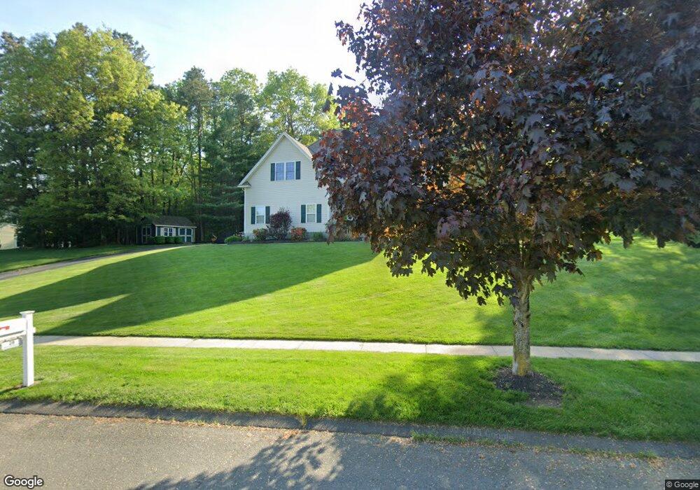
28 Sabrina Brooke Ln Westfield, MA 01085
Estimated Value: $575,000 - $661,203
4
Beds
3
Baths
2,647
Sq Ft
$232/Sq Ft
Est. Value
About This Home
This home is located at 28 Sabrina Brooke Ln, Westfield, MA 01085 and is currently estimated at $615,051, approximately $232 per square foot. 28 Sabrina Brooke Ln is a home located in Hampden County with nearby schools including Westfield High School, White Oak School, and Saint Mary High School.
Ownership History
Date
Name
Owned For
Owner Type
Purchase Details
Closed on
Nov 4, 2005
Sold by
Giberson Shaun C
Bought by
Shuman Christopher B and Shuman Kellye M
Current Estimated Value
Home Financials for this Owner
Home Financials are based on the most recent Mortgage that was taken out on this home.
Original Mortgage
$385,000
Outstanding Balance
$208,492
Interest Rate
5.85%
Mortgage Type
Purchase Money Mortgage
Estimated Equity
$406,559
Purchase Details
Closed on
Nov 3, 2004
Sold by
Scarfo Constr Inc
Bought by
Giberson Shaun C
Home Financials for this Owner
Home Financials are based on the most recent Mortgage that was taken out on this home.
Original Mortgage
$280,000
Interest Rate
5.71%
Mortgage Type
Purchase Money Mortgage
Create a Home Valuation Report for This Property
The Home Valuation Report is an in-depth analysis detailing your home's value as well as a comparison with similar homes in the area
Home Values in the Area
Average Home Value in this Area
Purchase History
| Date | Buyer | Sale Price | Title Company |
|---|---|---|---|
| Shuman Christopher B | $385,000 | -- | |
| Giberson Shaun C | $95,000 | -- |
Source: Public Records
Mortgage History
| Date | Status | Borrower | Loan Amount |
|---|---|---|---|
| Open | Shuman Christopher B | $385,000 | |
| Closed | Shuman Christopher B | $308,000 | |
| Previous Owner | Giberson Shaun C | $280,000 |
Source: Public Records
Tax History Compared to Growth
Tax History
| Year | Tax Paid | Tax Assessment Tax Assessment Total Assessment is a certain percentage of the fair market value that is determined by local assessors to be the total taxable value of land and additions on the property. | Land | Improvement |
|---|---|---|---|---|
| 2025 | $8,232 | $542,300 | $149,200 | $393,100 |
| 2024 | $8,277 | $518,300 | $136,400 | $381,900 |
| 2023 | $8,023 | $489,200 | $129,200 | $360,000 |
| 2022 | $8,023 | $433,900 | $115,600 | $318,300 |
| 2021 | $7,777 | $411,900 | $108,800 | $303,100 |
| 2020 | $7,662 | $398,000 | $108,800 | $289,200 |
| 2019 | $7,364 | $374,400 | $104,000 | $270,400 |
| 2018 | $7,248 | $374,400 | $104,000 | $270,400 |
| 2017 | $7,065 | $363,800 | $105,200 | $258,600 |
| 2016 | $7,072 | $363,800 | $105,200 | $258,600 |
| 2015 | $6,548 | $353,200 | $105,200 | $248,000 |
| 2014 | $4,903 | $353,200 | $105,200 | $248,000 |
Source: Public Records
Map
Nearby Homes
- 0 Cabot Rd
- 22 Root Rd
- 19 3rd Ave
- 50 Russellville Rd
- 194 Lockhouse Rd
- 48 Modena Cir
- 52 Simmons Brook Dr
- 3 Norton St
- 70 Yeoman Ave
- 240 Russellville Rd
- 13 Furrow St
- 19 Arch Rd
- 10 Ethan Ave
- 351 N Elm St
- 128 Skyline Dr
- 40 Prospect St Unit 2F
- 148 Prospect Street Extension
- 9 Crown St
- 48 Murray Ave
- 72-74 Notre Dame St
- 36 Sabrina Brooke Ln
- 18 Sabrina Brooke Ln
- 29 Sabrina Brooke Ln
- 13 Sabrina Brooke Ln
- 37 Sabrina Brooke Ln
- 11 Sabrina Brooke Ln
- 11 Sabrina Brooke Ln
- 44 Sabrina Brooke Ln
- 10 Sabrina Brooke Ln
- 7 Sabrina Brooke Ln
- 43 Sabrina Brooke Ln
- 336 Lockhouse Rd
- 1 Sabrina Brooke Ln Unit 1E
- 1 Sabrina Brooke Ln Unit 1B
- 1 Sabrina Brooke Ln Unit 1A
- 5 Sabrina Brooke Ln
- 8 Sabrina Brooke Ln
- 6 Sabrina Brooke Ln
- 4 Sabrina Brooke Ln
- 49 Sabrina Brooke Ln