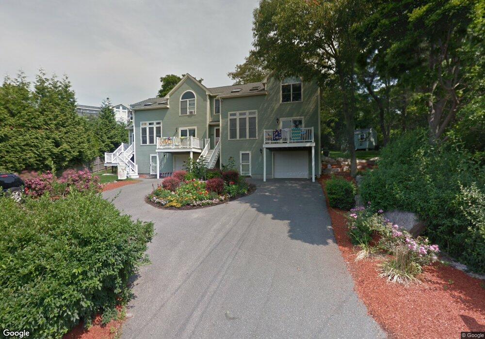
28 Witham St Unit A Gloucester, MA 01930
East Gloucester NeighborhoodEstimated Value: $896,000 - $1,029,000
3
Beds
3
Baths
1,902
Sq Ft
$501/Sq Ft
Est. Value
About This Home
This home is located at 28 Witham St Unit A, Gloucester, MA 01930 and is currently estimated at $952,110, approximately $500 per square foot. 28 Witham St Unit A is a home located in Essex County with nearby schools including East Gloucester Elementary School, Ralph B O'maley Middle School, and Gloucester High School.
Ownership History
Date
Name
Owned For
Owner Type
Purchase Details
Closed on
Aug 27, 2004
Sold by
Padre Jennifer G
Bought by
Liacos Peter F and Liacos Julie M
Current Estimated Value
Home Financials for this Owner
Home Financials are based on the most recent Mortgage that was taken out on this home.
Original Mortgage
$167,000
Outstanding Balance
$83,508
Interest Rate
6.02%
Mortgage Type
Purchase Money Mortgage
Estimated Equity
$868,602
Create a Home Valuation Report for This Property
The Home Valuation Report is an in-depth analysis detailing your home's value as well as a comparison with similar homes in the area
Home Values in the Area
Average Home Value in this Area
Purchase History
| Date | Buyer | Sale Price | Title Company |
|---|---|---|---|
| Liacos Peter F | $445,000 | -- |
Source: Public Records
Mortgage History
| Date | Status | Borrower | Loan Amount |
|---|---|---|---|
| Open | Liacos Peter F | $167,000 |
Source: Public Records
Tax History
| Year | Tax Paid | Tax Assessment Tax Assessment Total Assessment is a certain percentage of the fair market value that is determined by local assessors to be the total taxable value of land and additions on the property. | Land | Improvement |
|---|---|---|---|---|
| 2025 | $7,594 | $781,300 | $0 | $781,300 |
| 2024 | $7,124 | $732,200 | $0 | $732,200 |
| 2023 | $6,837 | $645,600 | $0 | $645,600 |
| 2022 | $6,840 | $583,100 | $0 | $583,100 |
| 2021 | $6,823 | $548,500 | $0 | $548,500 |
| 2020 | $6,915 | $560,800 | $0 | $560,800 |
| 2019 | $6,591 | $519,400 | $0 | $519,400 |
| 2018 | $6,032 | $466,500 | $0 | $466,500 |
| 2017 | $5,699 | $432,100 | $0 | $432,100 |
| 2016 | $5,414 | $397,800 | $0 | $397,800 |
| 2015 | $5,429 | $397,700 | $0 | $397,700 |
Source: Public Records
Map
Nearby Homes
- 32 Witham St Unit B
- 70 Old Nugent Farm Rd
- 78 Thatcher Rd Unit 6
- 25 Salt Island Rd
- 26 Marina Dr
- 5 Wise Place
- 3 Mondello Square
- 36 Eastern Ave
- 148 Long Beach
- 33 Highview Rd
- 87 Atlantic Rd Unit 2
- 15 Mount Vernon St
- 139A Prospect St
- 19 Trask St Unit 2
- 197 E Main St Unit 1
- 50 Warner St
- 177 Main St
- 40 Sargent St
- 113 Pleasant St
- 12 Arthur St
- 28 Witham St Unit B
- 26 Witham St
- 20 Witham St
- 24 Witham St
- 32 Witham St Unit A
- 32 Witham St
- 31 Witham St
- 35R Witham St
- 35 Witham St
- 22 Witham St Unit 2
- 22 Witham St Unit 1
- 22 Witham St
- 17 Witham St
- 18 Witham St
- 29 Witham St
- 41 Witrhham Unit R
- 43 Witham St
- 43 Witham St Unit 3
- 41 Witham St
- 41 Witham St Unit R
Your Personal Tour Guide
Ask me questions while you tour the home.