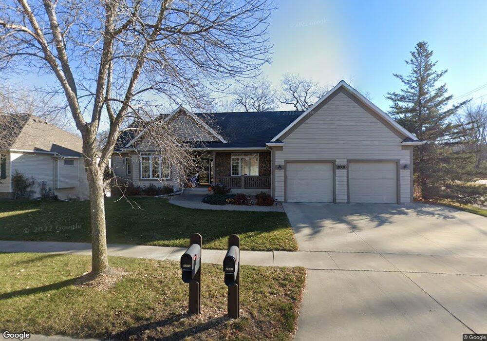
2801 Stonegate Ct SW Rochester, MN 55902
Estimated Value: $566,495 - $626,000
5
Beds
4
Baths
3,306
Sq Ft
$183/Sq Ft
Est. Value
About This Home
This home is located at 2801 Stonegate Ct SW, Rochester, MN 55902 and is currently estimated at $604,124, approximately $182 per square foot. 2801 Stonegate Ct SW is a home located in Olmsted County with nearby schools including Bamber Valley Elementary School, John Adams Middle School, and Mayo Senior High School.
Ownership History
Date
Name
Owned For
Owner Type
Purchase Details
Closed on
May 31, 2022
Sold by
Mock Jeffrey and Mock Linda
Bought by
Kelly John and Kellly Jane
Current Estimated Value
Purchase Details
Closed on
Jun 26, 2015
Sold by
Leavelle Sandra L and Leavelle Dennis E
Bought by
Mock Jeffrey and Mock Linda
Purchase Details
Closed on
Sep 28, 2010
Sold by
Leavelle Dennis E and Leavelle Sandra L
Bought by
Leavelle Sandra L and Leavelle Dennis E
Create a Home Valuation Report for This Property
The Home Valuation Report is an in-depth analysis detailing your home's value as well as a comparison with similar homes in the area
Home Values in the Area
Average Home Value in this Area
Purchase History
| Date | Buyer | Sale Price | Title Company |
|---|---|---|---|
| Kelly John | $519,000 | -- | |
| Mock Jeffrey | $346,200 | Rochester Title | |
| Leavelle Sandra L | -- | None Available |
Source: Public Records
Tax History Compared to Growth
Tax History
| Year | Tax Paid | Tax Assessment Tax Assessment Total Assessment is a certain percentage of the fair market value that is determined by local assessors to be the total taxable value of land and additions on the property. | Land | Improvement |
|---|---|---|---|---|
| 2024 | $7,256 | $512,400 | $60,000 | $452,400 |
| 2023 | $6,172 | $490,000 | $50,000 | $440,000 |
| 2022 | $5,384 | $431,700 | $50,000 | $381,700 |
| 2021 | $5,020 | $393,000 | $50,000 | $343,000 |
| 2020 | $5,046 | $368,000 | $30,000 | $338,000 |
| 2019 | $4,940 | $355,800 | $30,000 | $325,800 |
| 2018 | $4,856 | $350,500 | $32,400 | $318,100 |
| 2017 | $4,856 | $350,700 | $32,400 | $318,300 |
| 2016 | $4,626 | $331,800 | $31,800 | $300,000 |
| 2015 | $4,264 | $308,900 | $31,500 | $277,400 |
| 2014 | $2,025 | $302,700 | $31,400 | $271,300 |
| 2012 | -- | $294,600 | $31,357 | $263,243 |
Source: Public Records
Map
Nearby Homes
- 2944 Mayowood Common Cir SW
- 1975 Waterford Place SW
- 1987 Waterford Place SW
- 3018 Mayowood Common Cir SW
- 1650 Mayowood Ct SW
- 1710 Mayowood Ct SW
- 1658 Mayowood Ct SW
- 1726 Mayowood Rd SW
- 1702 Mayowood Ct SW
- 1750 Mayowood Rd SW
- 1739 Mayowood Ct SW
- 1758 Mayowood Rd SW
- 1787 Mayowood Rd SW
- 1782 Mayowood Ct SW
- 1798 Mayowood Rd SW
- 1806 Mayowood Rd SW
- 1835 Mayowood Rd SW
- 1851 Mayowood Ct SW
- 1568 Salem Ct SW
- 1822 Mayowood Rd SW
- 2805 Stonegate Ct SW
- 2718 Bamber Ln SW
- 2809 Stonegate Ct SW
- 2804 Stonegate Ct SW
- 2808 Stonegate Ct SW
- 2813 Stonegate Ct SW
- 2723 Bamber Ln SW
- 2710 Bamber Ln SW
- 2812 Stonegate Ct SW
- 2008 Magdalana Ln SW
- 2817 Stonegate Ct SW
- 2816 Stonegate Ct SW
- 2702 Bamber Ln SW
- 2715 Bamber Ln SW
- 2002 Magdalana Ln SW
- 2821 Stonegate Ct SW
- 2705 Bamber Ln SW
- 2626 Bamber Ln SW
- 2732 Mayowood Ln SW
- 2726 Mayowood Ln SW