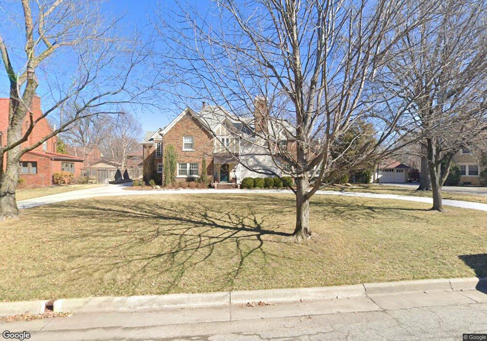
282 S Pershing St Wichita, KS 67218
College Hill NeighborhoodEstimated Value: $712,663
4
Beds
4
Baths
5,091
Sq Ft
$140/Sq Ft
Est. Value
About This Home
This home is located at 282 S Pershing St, Wichita, KS 67218 and is currently estimated at $712,663, approximately $139 per square foot. 282 S Pershing St is a home located in Sedgwick County with nearby schools including Hyde Leadership and International Exploration Magnet Elementary, Robinson Middle School, and Wichita High School East.
Ownership History
Date
Name
Owned For
Owner Type
Purchase Details
Closed on
Jun 3, 2014
Sold by
Robinson C Scott and Robinson Ann L
Bought by
C Scott Robinson Revocable Trust and Robinson Ann L
Current Estimated Value
Purchase Details
Closed on
May 10, 2010
Sold by
Derreberry Bryan S and Derreberry Gail A
Bought by
Robinson Curtis Scott and Robinson Ann L
Home Financials for this Owner
Home Financials are based on the most recent Mortgage that was taken out on this home.
Original Mortgage
$222,350
Interest Rate
5.02%
Mortgage Type
New Conventional
Create a Home Valuation Report for This Property
The Home Valuation Report is an in-depth analysis detailing your home's value as well as a comparison with similar homes in the area
Home Values in the Area
Average Home Value in this Area
Purchase History
| Date | Buyer | Sale Price | Title Company |
|---|---|---|---|
| C Scott Robinson Revocable Trust | -- | None Available | |
| Robinson Curtis Scott | -- | Security 1St Title |
Source: Public Records
Mortgage History
| Date | Status | Borrower | Loan Amount |
|---|---|---|---|
| Closed | Robinson Curtis Scott | $222,350 |
Source: Public Records
Tax History Compared to Growth
Tax History
| Year | Tax Paid | Tax Assessment Tax Assessment Total Assessment is a certain percentage of the fair market value that is determined by local assessors to be the total taxable value of land and additions on the property. | Land | Improvement |
|---|---|---|---|---|
| 2025 | $8,187 | $79,604 | $7,602 | $72,002 |
| 2023 | $8,187 | $73,025 | $6,992 | $66,033 |
| 2022 | $8,323 | $73,025 | $6,601 | $66,424 |
| 2021 | $8,443 | $73,025 | $6,601 | $66,424 |
| 2020 | $8,032 | $69,217 | $6,601 | $62,616 |
| 2019 | $7,322 | $63,020 | $6,601 | $56,419 |
| 2018 | $6,995 | $60,019 | $5,647 | $54,372 |
| 2017 | $6,795 | $0 | $0 | $0 |
| 2016 | $6,463 | $0 | $0 | $0 |
| 2015 | $6,416 | $0 | $0 | $0 |
| 2014 | $6,246 | $0 | $0 | $0 |
Source: Public Records
Map
Nearby Homes
- 4712 E English St
- 444 S Glendale St
- 227 S Glendale St
- 461 S Elpyco Ave
- 4901 E Orme St
- 102 N Terrace Dr
- 155 S Battin St
- 116 N Glendale Ave
- 139 N Dellrose Ave
- 130 N Terrace Dr
- 602 S Bluff St
- 739 S Dellrose St
- 722 S Belmont Ave
- 736 S Terrace Dr
- 216 N Terrace Dr
- 202 N Glendale St
- 742 S Crestway St
- 739 S Terrace Dr
- 722 S Broadview Ave
- 618 Sylvan Ln
- 276 S Pershing St
- 285 S Dellrose St
- 290 S Pershing St
- 275 S Dellrose St
- 270 S Pershing St
- 273 S Dellrose St
- 269 S Dellrose Ave
- 269 S Dellrose St
- 275 S Pershing St
- 258 S Pershing St
- 285 S Pershing St
- 265 S Dellrose St
- 297 S Pershing St
- 263 S Pershing St
- 412 S Dellrose St
- 4701 E Lewis St
- 261 S Dellrose St
- 250 S Pershing St
- 276 S Dellrose St
- 400 S Pershing St