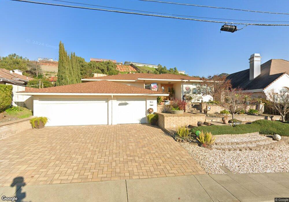
2820 Darius Way San Leandro, CA 94577
Bay-O-Vista NeighborhoodEstimated Value: $1,194,000 - $1,329,000
4
Beds
2
Baths
2,218
Sq Ft
$557/Sq Ft
Est. Value
About This Home
This home is located at 2820 Darius Way, San Leandro, CA 94577 and is currently estimated at $1,235,355, approximately $556 per square foot. 2820 Darius Way is a home located in Alameda County with nearby schools including Roosevelt Elementary School, Bancroft Middle School, and San Leandro High School.
Ownership History
Date
Name
Owned For
Owner Type
Purchase Details
Closed on
Mar 13, 2009
Sold by
Martinez Leonard S and Martinez Irene C
Bought by
Newton Gene A and Newton Deborah
Current Estimated Value
Home Financials for this Owner
Home Financials are based on the most recent Mortgage that was taken out on this home.
Original Mortgage
$528,000
Outstanding Balance
$336,803
Interest Rate
5.19%
Mortgage Type
Purchase Money Mortgage
Estimated Equity
$898,552
Purchase Details
Closed on
Apr 1, 1994
Sold by
Martinez Leonard S and Martinez Irene C
Bought by
Martinez Leonard S and Martinez Irene C
Create a Home Valuation Report for This Property
The Home Valuation Report is an in-depth analysis detailing your home's value as well as a comparison with similar homes in the area
Home Values in the Area
Average Home Value in this Area
Purchase History
| Date | Buyer | Sale Price | Title Company |
|---|---|---|---|
| Newton Gene A | $660,000 | Old Republic Title Company | |
| Martinez Leonard S | -- | -- |
Source: Public Records
Mortgage History
| Date | Status | Borrower | Loan Amount |
|---|---|---|---|
| Open | Newton Gene A | $528,000 |
Source: Public Records
Tax History
| Year | Tax Paid | Tax Assessment Tax Assessment Total Assessment is a certain percentage of the fair market value that is determined by local assessors to be the total taxable value of land and additions on the property. | Land | Improvement |
|---|---|---|---|---|
| 2025 | $11,055 | $842,861 | $254,958 | $594,903 |
| 2024 | $11,055 | $826,203 | $249,961 | $583,242 |
| 2023 | $10,991 | $816,868 | $245,060 | $571,808 |
| 2022 | $10,685 | $793,857 | $240,257 | $560,600 |
| 2021 | $10,363 | $778,155 | $235,546 | $549,609 |
| 2020 | $10,101 | $777,110 | $233,133 | $543,977 |
| 2019 | $9,801 | $761,877 | $228,563 | $533,314 |
| 2018 | $9,560 | $746,941 | $224,082 | $522,859 |
| 2017 | $9,365 | $732,295 | $219,688 | $512,607 |
| 2016 | $8,874 | $717,940 | $215,382 | $502,558 |
| 2015 | $8,718 | $707,163 | $212,149 | $495,014 |
| 2014 | $8,650 | $693,316 | $207,995 | $485,321 |
Source: Public Records
Map
Nearby Homes
- 14644 Saturn Dr
- 1269 Gabriel Ct
- 0 Saturn Dr
- 2245 Sol St
- 0 Montrose Dr
- 1233 Benedict Ct
- 14831 Bancroft Ave Unit Space 27
- 1541 152nd Ave
- 15675 Liberty St
- 845 Dolores Ave
- 1316 135th Ave
- 824 Maud Ave
- 1468 Grand Ave Unit 5
- 1468 Grand Ave Unit 21
- 15065 Hesperian Blvd Unit 22
- 1592 Oriole Ave
- 1449 Sandelin Ave
- 970 Joaquin Ave Unit U7
- 2399 E 14th St Unit 66
- 2399 E 14th St Unit 24
- 2816 Darius Way
- 2828 Darius Way
- 2862 Darius Way
- 2800 Darius Way
- 0 Darius Way Unit 40521325
- 0 Darius Way Unit 41085298
- 0 Darius Way Unit 41050979
- 1723 Vistagrand Dr
- 1587 Darius Ct
- 1737 Vistagrand Dr
- 2780 Darius Way
- 2815 Darius Way
- 1705 Vistagrand Dr
- 1565 Darius Ct
- 2771 Darius Way
- 2827 Darius Way
- 1749 Vistagrand Dr
- 2768 Darius Way
- 1689 Vistagrand Dr
- 2869 Darius Way
Your Personal Tour Guide
Ask me questions while you tour the home.