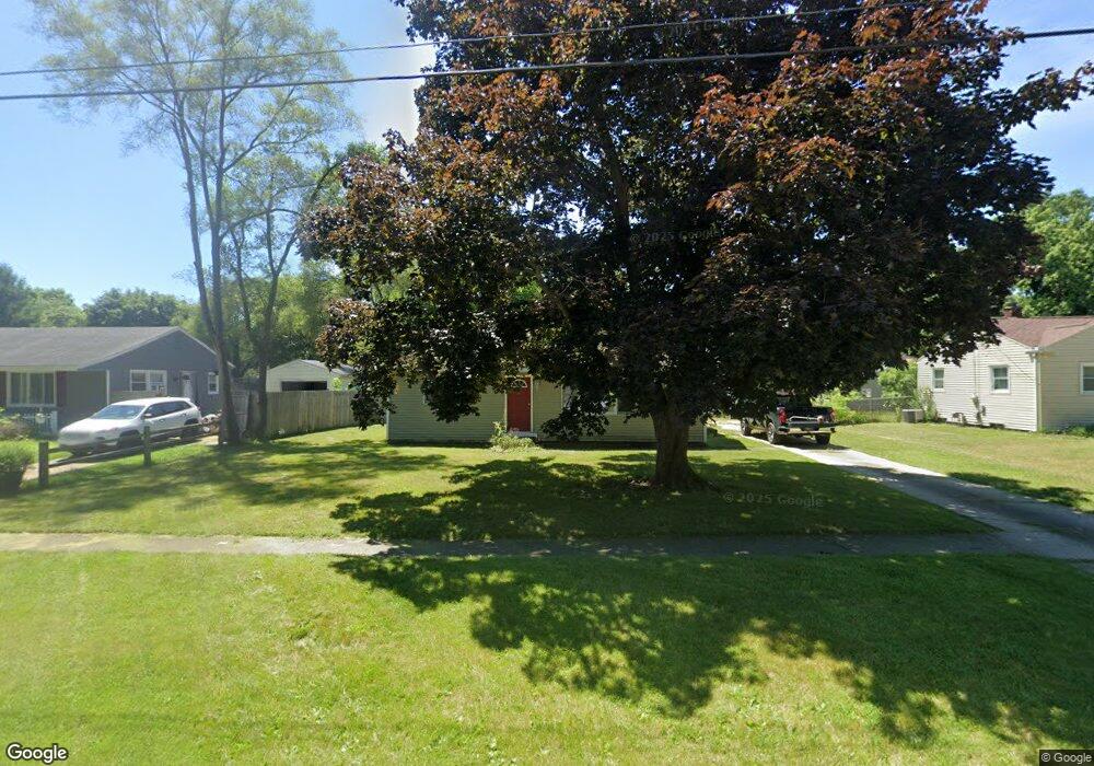
2825 Range St Kalamazoo, MI 49004
Burke Acres NeighborhoodEstimated Value: $164,000 - $200,000
3
Beds
1
Bath
1,725
Sq Ft
$105/Sq Ft
Est. Value
About This Home
This home is located at 2825 Range St, Kalamazoo, MI 49004 and is currently estimated at $181,475, approximately $105 per square foot. 2825 Range St is a home located in Kalamazoo County with nearby schools including Spring Valley Center for Exploration, Hillside Middle School, and Kalamazoo Central High School.
Ownership History
Date
Name
Owned For
Owner Type
Purchase Details
Closed on
Feb 17, 2005
Sold by
Turner Dawn Vanette
Bought by
Deutsche Bank National Trust Co and Ameriquest Mortgage Securities Inc Asset
Current Estimated Value
Purchase Details
Closed on
Dec 10, 2003
Sold by
Turner Paul Jonathan and Turner Paul
Bought by
Turner Dawn Vanette
Home Financials for this Owner
Home Financials are based on the most recent Mortgage that was taken out on this home.
Original Mortgage
$59,800
Interest Rate
11.95%
Mortgage Type
Stand Alone Refi Refinance Of Original Loan
Create a Home Valuation Report for This Property
The Home Valuation Report is an in-depth analysis detailing your home's value as well as a comparison with similar homes in the area
Home Values in the Area
Average Home Value in this Area
Purchase History
| Date | Buyer | Sale Price | Title Company |
|---|---|---|---|
| Deutsche Bank National Trust Co | $102,865 | -- | |
| Turner Dawn Vanette | -- | Title Bond |
Source: Public Records
Mortgage History
| Date | Status | Borrower | Loan Amount |
|---|---|---|---|
| Previous Owner | Turner Dawn Vanette | $59,800 |
Source: Public Records
Tax History
| Year | Tax Paid | Tax Assessment Tax Assessment Total Assessment is a certain percentage of the fair market value that is determined by local assessors to be the total taxable value of land and additions on the property. | Land | Improvement |
|---|---|---|---|---|
| 2025 | $1,194 | $65,500 | $0 | $0 |
| 2024 | $878 | $52,100 | $0 | $0 |
| 2023 | $837 | $47,000 | $0 | $0 |
| 2022 | $1,525 | $44,000 | $0 | $0 |
| 2021 | $1,474 | $40,900 | $0 | $0 |
| 2020 | $1,444 | $38,000 | $0 | $0 |
| 2019 | $1,377 | $33,400 | $0 | $0 |
| 2018 | $1,344 | $30,700 | $0 | $0 |
| 2017 | $1,456 | $29,800 | $0 | $0 |
| 2016 | $1,456 | $27,300 | $0 | $0 |
| 2015 | $1,456 | $26,400 | $0 | $0 |
| 2014 | $1,456 | $27,300 | $0 | $0 |
Source: Public Records
Map
Nearby Homes
- 3115 Michael Ave
- 3104 Courtlandt Ave
- 2516 Fairfield Ave
- 2407 Fairfield Ave
- 2428 Glendale Blvd
- 2842 Virginia Ave
- 2117 Lakewood Dr
- 2511 Monterey Dr
- 2415 Parchmount Ave
- 2716 Gull Rd
- 2421 Parchmount Ave
- 1223 Parchmount Ave
- 2910 Parchmount Ave
- 818 Parchmount Ave
- 603 Park Ave
- 125 Haymac Dr
- 332 Espanola Ave
- 2412 Sonora St
- 405 Park Ave
- 1734 Texel Dr
Your Personal Tour Guide
Ask me questions while you tour the home.