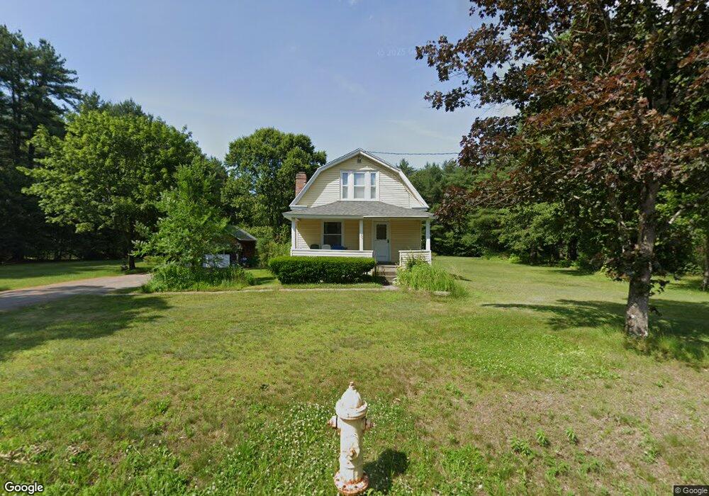
283 Log Plain Rd Greenfield, MA 01301
Estimated Value: $333,109 - $453,000
3
Beds
2
Baths
1,391
Sq Ft
$274/Sq Ft
Est. Value
About This Home
This home is located at 283 Log Plain Rd, Greenfield, MA 01301 and is currently estimated at $381,777, approximately $274 per square foot. 283 Log Plain Rd is a home located in Franklin County with nearby schools including Greenfield Center School, Cornerstone Christian School, and Stoneleigh-Burnham School.
Ownership History
Date
Name
Owned For
Owner Type
Purchase Details
Closed on
Feb 8, 2008
Sold by
Sokolosk Edward R and Sokolosk Edward R
Bought by
Sokoloski Maxine H
Current Estimated Value
Create a Home Valuation Report for This Property
The Home Valuation Report is an in-depth analysis detailing your home's value as well as a comparison with similar homes in the area
Home Values in the Area
Average Home Value in this Area
Purchase History
| Date | Buyer | Sale Price | Title Company |
|---|---|---|---|
| Sokoloski Maxine H | -- | -- | |
| Sokoloski Edward R | -- | -- | |
| Sokoloski Edward R | -- | -- |
Source: Public Records
Mortgage History
| Date | Status | Borrower | Loan Amount |
|---|---|---|---|
| Open | Sokoloski Edward R | $50,000 | |
| Previous Owner | Sokoloski Edward R | $50,000 | |
| Previous Owner | Sokoloski Edward R | $23,000 | |
| Previous Owner | Sokoloski Edward R | $50,000 |
Source: Public Records
Tax History
| Year | Tax Paid | Tax Assessment Tax Assessment Total Assessment is a certain percentage of the fair market value that is determined by local assessors to be the total taxable value of land and additions on the property. | Land | Improvement |
|---|---|---|---|---|
| 2025 | $4,857 | $248,300 | $93,000 | $155,300 |
| 2024 | $4,777 | $234,300 | $79,700 | $154,600 |
| 2023 | $4,352 | $221,500 | $79,700 | $141,800 |
| 2022 | $4,553 | $204,000 | $80,300 | $123,700 |
| 2021 | $4,558 | $196,300 | $84,300 | $112,000 |
| 2020 | $4,416 | $192,600 | $84,300 | $108,300 |
| 2019 | $4,054 | $181,300 | $74,700 | $106,600 |
| 2018 | $3,995 | $178,100 | $73,500 | $104,600 |
| 2017 | $3,896 | $179,300 | $73,500 | $105,800 |
| 2016 | $3,906 | $179,100 | $73,500 | $105,600 |
| 2015 | $3,890 | $172,800 | $75,100 | $97,700 |
| 2014 | $3,548 | $172,800 | $75,100 | $97,700 |
Source: Public Records
Map
Nearby Homes
- 001 Adams Rd
- 47 Cross St
- 34 Brookside Ave
- 85 Verde Dr
- 696 Bernardston Rd
- 75 South St Unit 3
- 18 Lillian St
- 23 Industrial Dr
- 25 Barton Rd
- 1 Northfield Rd
- 0 Fox Hill Rd Unit 73477185
- 20 Walnut St
- 6 Burrows Turnpike Rd
- 182 Main Rd
- 539 Fox Hill Rd
- 20 Dunnell Rd
- 132 Poplar St
- 77 Summer St
- 116 Bald Mountain Rd
- 372 Federal St
- 271 Log Plain Rd
- 280 Log Plain Rd
- 267 Log Plain Rd
- 299 Log Plain Rd
- 298 Log Plain Rd
- 259 Log Plain Rd
- 307 Log Plain Rd
- 260 Log Plain Rd
- 0 Fargo St
- 1207 Bernardston Rd
- 8 Fargo St
- 311 Log Plain Rd
- 252 Log Plain Rd
- 26 Fargo St
- 1175 Bernardston Rd
- 1173 Bernardston Rd
- 316 Log Plain Rd
- 319 Log Plain Rd
- 39 E Wayland Dr
- 32 Fargo St
Your Personal Tour Guide
Ask me questions while you tour the home.