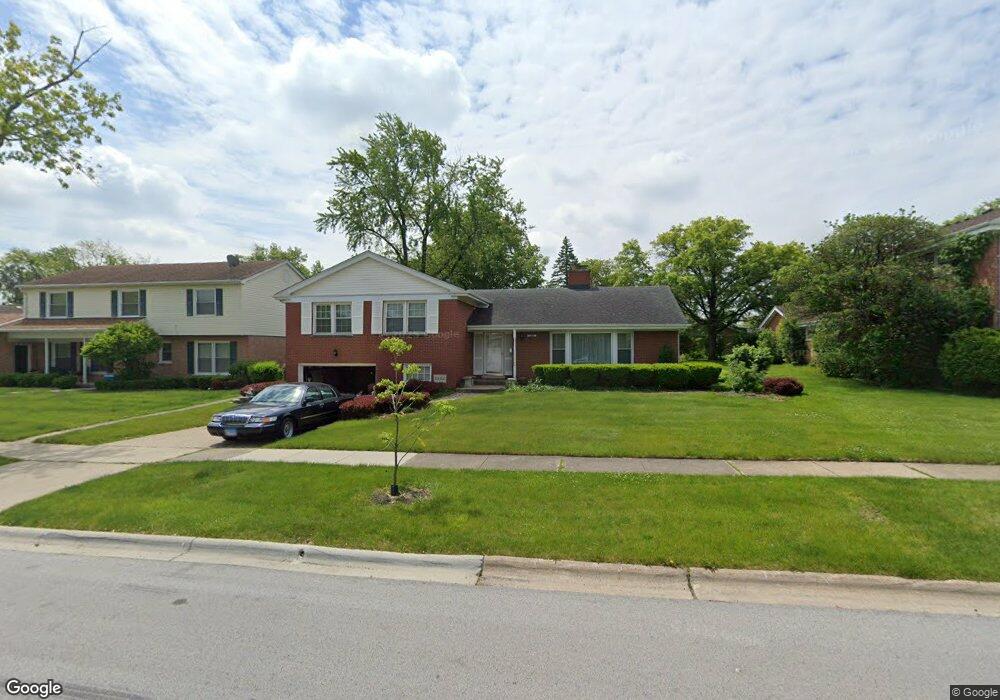
2832 Bob o Link Rd Flossmoor, IL 60422
Estimated Value: $269,000 - $322,000
4
Beds
3
Baths
1,649
Sq Ft
$184/Sq Ft
Est. Value
About This Home
This home is located at 2832 Bob o Link Rd, Flossmoor, IL 60422 and is currently estimated at $303,808, approximately $184 per square foot. 2832 Bob o Link Rd is a home located in Cook County with nearby schools including Heather Hill Elementary School, Parker Junior High School, and Homewood-Flossmoor High School.
Ownership History
Date
Name
Owned For
Owner Type
Purchase Details
Closed on
Nov 15, 2014
Sold by
Brown William J and Brown Dortha E
Bought by
Brown William J and Brown Dortha E
Current Estimated Value
Home Financials for this Owner
Home Financials are based on the most recent Mortgage that was taken out on this home.
Original Mortgage
$131,400
Interest Rate
4.87%
Mortgage Type
New Conventional
Create a Home Valuation Report for This Property
The Home Valuation Report is an in-depth analysis detailing your home's value as well as a comparison with similar homes in the area
Home Values in the Area
Average Home Value in this Area
Purchase History
| Date | Buyer | Sale Price | Title Company |
|---|---|---|---|
| Brown William J | -- | None Available |
Source: Public Records
Mortgage History
| Date | Status | Borrower | Loan Amount |
|---|---|---|---|
| Closed | Brown William J | $131,400 |
Source: Public Records
Tax History
| Year | Tax Paid | Tax Assessment Tax Assessment Total Assessment is a certain percentage of the fair market value that is determined by local assessors to be the total taxable value of land and additions on the property. | Land | Improvement |
|---|---|---|---|---|
| 2025 | $7,742 | $24,157 | $5,968 | $18,189 |
| 2024 | $7,742 | $24,157 | $5,968 | $18,189 |
| 2023 | $7,336 | $24,157 | $5,968 | $18,189 |
| 2022 | $7,336 | $19,798 | $5,154 | $14,644 |
| 2021 | $7,437 | $19,796 | $5,153 | $14,643 |
| 2020 | $7,336 | $19,796 | $5,153 | $14,643 |
| 2019 | $6,083 | $17,460 | $4,611 | $12,849 |
| 2018 | $5,848 | $17,460 | $4,611 | $12,849 |
| 2017 | $5,797 | $17,460 | $4,611 | $12,849 |
| 2016 | $5,999 | $15,608 | $4,068 | $11,540 |
| 2015 | $5,913 | $15,608 | $4,068 | $11,540 |
| 2014 | $5,850 | $15,608 | $4,068 | $11,540 |
| 2013 | $4,911 | $14,787 | $4,068 | $10,719 |
Source: Public Records
Map
Nearby Homes
- 1402 Berry Ln
- 1248 Berry Ln
- 3006 Polly Ln
- 2931 Sunset Ave
- 1141 Leavitt Ave Unit 115
- 1139 Leavitt Ave Unit 313
- 2937 Kathleen Ln
- 2940 Flossmoor Rd
- 3038 Candlewood Ct Unit 24
- 2633 Hawthorne Ln Unit B
- 1117 Leavitt Ave Unit 110
- 2817 Flossmoor Rd
- 3118 Elaine Ct Unit 232
- 2929 Flossmoor Rd
- 1430 Brassie Ave
- 1450 Tanglewood St Unit 1B
- 2640 Central Dr Unit 1-N
- 1723 Oak Lane Rd
- 2622 Central Dr Unit 2N
- 1002 Douglas Ave
- 2828 Bob o Link Rd
- 1319 Berry Ln
- 1403 Berry Ln
- 2822 Bob o Link Rd
- 1409 Berry Ln
- 1348 Berry Ln
- 2831 Bob o Link Rd
- 1305 Berry Ln
- 2816 Bob o Link Rd
- 1418 Douglas Ave
- 1274 Oakmont Ave
- 1415 Berry Ln
- 1414 Douglas Ave
- 2902 Bob o Link Rd
- 1422 Douglas Ave
- 1266 Berry Ln
- 1410 Douglas Ave
- 1261 Berry Ln
- 1317 Oakmont Ave
- 1408 Berry Ln