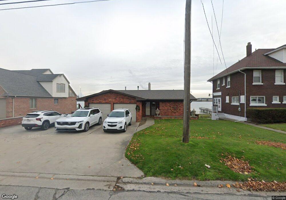
2832 Military St Port Huron, MI 48060
Estimated Value: $263,000 - $592,000
3
Beds
3
Baths
1,571
Sq Ft
$288/Sq Ft
Est. Value
About This Home
This home is located at 2832 Military St, Port Huron, MI 48060 and is currently estimated at $452,690, approximately $288 per square foot. 2832 Military St is a home located in St. Clair County with nearby schools including Woodrow Wilson Elementary School, Central Middle School, and Port Huron High School.
Ownership History
Date
Name
Owned For
Owner Type
Purchase Details
Closed on
Feb 1, 2021
Sold by
May Robert W and May Amy L
Bought by
Robert And Amy May Living Trust and May
Current Estimated Value
Purchase Details
Closed on
Nov 24, 2020
Sold by
May Robert W and May Amy L
Bought by
May Robert Walter and May Amy Lynn
Purchase Details
Closed on
Sep 21, 2015
Sold by
Gladwish Revocable Trust
Bought by
May Robert W and May Amy L
Purchase Details
Closed on
Apr 7, 2011
Sold by
Gladwish Michael P and Gladwish Nancy L
Bought by
Gladwish Michael P and Gladwish Nancy L
Create a Home Valuation Report for This Property
The Home Valuation Report is an in-depth analysis detailing your home's value as well as a comparison with similar homes in the area
Home Values in the Area
Average Home Value in this Area
Purchase History
| Date | Buyer | Sale Price | Title Company |
|---|---|---|---|
| Robert And Amy May Living Trust | -- | Deshon Stacy | |
| May Robert Walter | -- | None Available | |
| May Robert W | $385,000 | Maritime Title | |
| Gladwish Michael P | -- | None Available |
Source: Public Records
Tax History Compared to Growth
Tax History
| Year | Tax Paid | Tax Assessment Tax Assessment Total Assessment is a certain percentage of the fair market value that is determined by local assessors to be the total taxable value of land and additions on the property. | Land | Improvement |
|---|---|---|---|---|
| 2025 | $8,225 | $261,200 | $0 | $0 |
| 2024 | $7,330 | $245,400 | $0 | $0 |
| 2023 | $6,923 | $230,700 | $0 | $0 |
| 2022 | $7,663 | $199,500 | $0 | $0 |
| 2021 | $7,270 | $171,400 | $0 | $0 |
| 2020 | $7,353 | $163,400 | $163,400 | $0 |
| 2019 | $7,268 | $176,100 | $0 | $0 |
| 2018 | $7,203 | $176,100 | $0 | $0 |
| 2017 | $7,223 | $196,100 | $0 | $0 |
| 2016 | $7,031 | $196,100 | $0 | $0 |
| 2015 | $5,632 | $199,700 | $199,700 | $0 |
| 2014 | $5,632 | $185,800 | $185,800 | $0 |
| 2013 | -- | $163,100 | $0 | $0 |
Source: Public Records
Map
Nearby Homes
- 2815 Military St
- 2724 Military St
- 2704 Military St
- 2718 Electric Ave
- 2710 Electric Ave
- 1403 Catherine McAuley Dr
- 3136 Military St
- 2411 10th St
- 1414 Beard St
- 2444 Military St
- 2430 Military St Unit 2434
- 823 Beard St
- 9999 Cleveland Ave
- 730 Jenkinson St
- 913 Tunnel St
- 2627 24th St
- 1112 Minnie St
- 2109 Military St
- 1127 Minnie St
- 831 Bancroft St
- 2844 Military St
- 2830 Military St
- 2845 Military St
- 2856 Military St
- 2828 Military St
- 2858 Military St
- 2853 Military St
- 2825 Military St
- 2821 Military St
- 2861 Military St
- 2847 Military St
- 2863 Military St
- 2859 Military St
- 2864 Military St
- 2806 Military St
- 2836 Electric Ave
- 2830 Electric Ave
- 2880 Military St
- 2802 Military St
- 2869 Military St