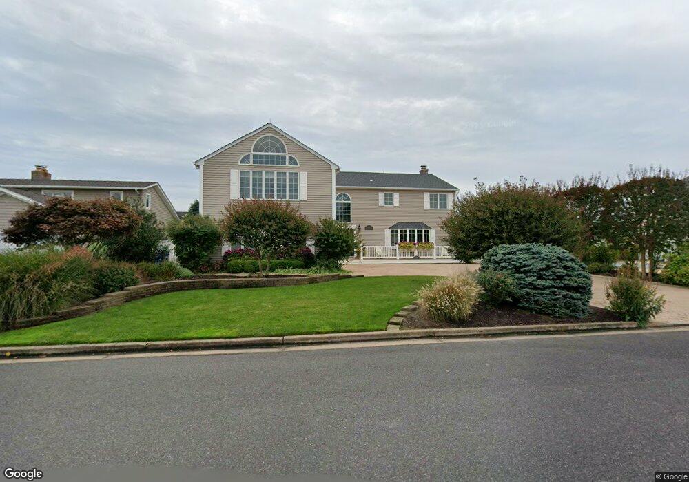
284 Curtis Point Dr Mantoloking, NJ 08738
Estimated Value: $2,614,000 - $3,941,000
5
Beds
4
Baths
4,182
Sq Ft
$810/Sq Ft
Est. Value
About This Home
This home is located at 284 Curtis Point Dr, Mantoloking, NJ 08738 and is currently estimated at $3,386,950, approximately $809 per square foot. 284 Curtis Point Dr is a home located in Ocean County with nearby schools including Emma Havens Young Elementary School, Lake Riviera Middle School, and Brick Township High School.
Ownership History
Date
Name
Owned For
Owner Type
Purchase Details
Closed on
Nov 5, 2024
Sold by
Sonta John A
Bought by
Sonta John A and Sonta Eden K
Current Estimated Value
Purchase Details
Closed on
Mar 1, 2023
Sold by
Sonta Jarret W
Bought by
Sonta John A
Purchase Details
Closed on
Jun 27, 1991
Bought by
Sonta Mary and Sonta John
Create a Home Valuation Report for This Property
The Home Valuation Report is an in-depth analysis detailing your home's value as well as a comparison with similar homes in the area
Home Values in the Area
Average Home Value in this Area
Purchase History
| Date | Buyer | Sale Price | Title Company |
|---|---|---|---|
| Sonta John A | -- | None Listed On Document | |
| Sonta John A | -- | None Listed On Document | |
| Sonta John A | -- | -- | |
| Sonta John A | -- | None Listed On Document | |
| Sonta Mary | $490,000 | -- |
Source: Public Records
Tax History Compared to Growth
Tax History
| Year | Tax Paid | Tax Assessment Tax Assessment Total Assessment is a certain percentage of the fair market value that is determined by local assessors to be the total taxable value of land and additions on the property. | Land | Improvement |
|---|---|---|---|---|
| 2025 | $31,474 | $1,218,500 | $730,100 | $488,400 |
| 2024 | $29,914 | $1,218,500 | $730,100 | $488,400 |
| 2023 | $29,524 | $1,218,500 | $730,100 | $488,400 |
| 2022 | $29,524 | $1,218,500 | $730,100 | $488,400 |
| 2021 | $28,903 | $1,218,500 | $730,100 | $488,400 |
| 2020 | $28,537 | $1,218,500 | $730,100 | $488,400 |
| 2019 | $28,062 | $1,218,500 | $730,100 | $488,400 |
| 2018 | $27,416 | $1,218,500 | $730,100 | $488,400 |
| 2017 | $26,673 | $1,218,500 | $730,100 | $488,400 |
| 2016 | $26,539 | $1,218,500 | $730,100 | $488,400 |
| 2015 | $25,844 | $1,218,500 | $730,100 | $488,400 |
| 2014 | $25,637 | $1,218,500 | $730,100 | $488,400 |
Source: Public Records
Map
Nearby Homes
- 275 Curtis Point Dr
- 233 Curtis Point Dr
- 122 Squan Beach Dr
- 304 Schooner Ln
- 150 Sunset Ln
- 1519 Runyon Ln
- 366 Highway 35 N
- 438 Highway 35 N Unit 1304
- 12 Shell Rd
- 1207 Ocean Ave
- 1201 Ocean Ave
- 124 Saint Lawrence Blvd
- 64 W Granada Dr
- 45 W Granada Dr
- 108 Rochester Dr
- 515 New Jersey 35
- 1097 Barnegat Ln
- 29 W Pampano Dr
- 545 Route 35
- 28 Commodore Dr
- 282 Curtis Point Dr
- 292 Curtis Point Dr
- 276 Curtis Point Dr
- 283 Curtis Point Dr
- 279 Curtis Point Dr
- 287 Curtis Point Dr
- 272 Curtis Point Dr
- 185 Squan Beach Dr
- 189 Squan Beach Dr
- 291 Curtis Point Dr
- 271 Curtis Point Dr
- 181 Squan Beach Dr
- 193 Squan Beach Dr
- 296 Curtis Point Dr
- 268 Curtis Point Dr
- 177 Squan Beach Dr
- 197 Squan Beach Dr
- 267 Curtis Point Dr
- 295 Curtis Point Dr
- 201 Squan Beach Dr