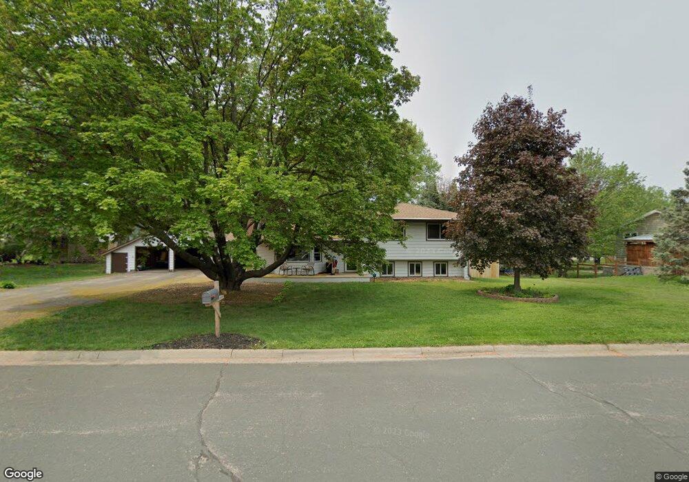
2841 Burnside Ave Saint Paul, MN 55121
Estimated Value: $446,502 - $507,000
3
Beds
3
Baths
2,032
Sq Ft
$230/Sq Ft
Est. Value
About This Home
This home is located at 2841 Burnside Ave, Saint Paul, MN 55121 and is currently estimated at $467,626, approximately $230 per square foot. 2841 Burnside Ave is a home located in Dakota County with nearby schools including Pilot Knob STEM Magnet School, Friendly Hills Middle School, and Two Rivers High School.
Ownership History
Date
Name
Owned For
Owner Type
Purchase Details
Closed on
May 24, 2021
Sold by
Kreitz William J and Kreitz Merry E
Bought by
Anderson Nathaniel and Jones Justine
Current Estimated Value
Home Financials for this Owner
Home Financials are based on the most recent Mortgage that was taken out on this home.
Original Mortgage
$380,000
Outstanding Balance
$343,292
Interest Rate
2.9%
Mortgage Type
New Conventional
Estimated Equity
$124,334
Purchase Details
Closed on
Aug 29, 2016
Sold by
Kreitz William J and Kreitz Merry E
Bought by
Kreitz Merry E and Kreitz William K
Create a Home Valuation Report for This Property
The Home Valuation Report is an in-depth analysis detailing your home's value as well as a comparison with similar homes in the area
Home Values in the Area
Average Home Value in this Area
Purchase History
| Date | Buyer | Sale Price | Title Company |
|---|---|---|---|
| Anderson Nathaniel | $410,000 | Burnet Title | |
| Kreitz Merry E | -- | None Available | |
| Anderson Nathaniel Nathaniel | $410,000 | -- |
Source: Public Records
Mortgage History
| Date | Status | Borrower | Loan Amount |
|---|---|---|---|
| Open | Anderson Nathaniel | $380,000 | |
| Closed | Anderson Nathaniel Nathaniel | $380,000 |
Source: Public Records
Tax History
| Year | Tax Paid | Tax Assessment Tax Assessment Total Assessment is a certain percentage of the fair market value that is determined by local assessors to be the total taxable value of land and additions on the property. | Land | Improvement |
|---|---|---|---|---|
| 2024 | $3,918 | $426,200 | $101,000 | $325,200 |
| 2023 | $3,918 | $438,600 | $101,300 | $337,300 |
| 2022 | $3,408 | $426,700 | $101,000 | $325,700 |
| 2021 | $3,174 | $360,400 | $87,800 | $272,600 |
| 2020 | $3,316 | $327,700 | $75,000 | $252,700 |
| 2019 | $3,415 | $330,600 | $71,400 | $259,200 |
| 2018 | $2,917 | $326,400 | $68,000 | $258,400 |
| 2017 | $2,894 | $286,300 | $64,800 | $221,500 |
| 2016 | $2,840 | $272,400 | $61,700 | $210,700 |
| 2015 | $2,910 | $252,155 | $58,599 | $193,556 |
| 2014 | -- | $249,975 | $56,920 | $193,055 |
| 2013 | -- | $238,748 | $51,389 | $187,359 |
Source: Public Records
Map
Nearby Homes
- 2850 Pilot Knob Rd
- 1360 Lone Oak Rd
- 3030 Shields Dr Unit 105
- 3016 Timberwood Trail Unit 2
- 3050 Shields Dr Unit 103
- 1329 Towerview Rd
- 3020 Woodlark Ln
- 3062 Woodlark Ln
- 1062 Kenneth St
- 3112 Farnum Dr Unit A
- 1700 Four Oaks Rd Unit 314B
- 1603 Raindrop Dr
- 3245 Evergreen Dr
- 1621 City View Dr
- 3250 Hill Ridge Dr Unit 82
- 3271 Valley Ridge Dr Unit 33
- 3426 Highlander Dr
- 1490 Woodview Ave E
- 3470 Greenwood Ct S
- 1654 Hunt Dr
- 2835 Burnside Ave
- 2845 Burnside Ave
- 2866 Fairlawn Place
- 2890 Fairlawn Place
- 2844 Beam Ln
- 2829 Burnside Ave
- 2894 Fairlawn Place
- 2832 Beam Ln
- 2875 Fairlawn Place
- 2893 Fairlawn Place
- 2821 Burnside Ave
- 2816 Beam Ln
- 2899 Fairlawn Place
- 2898 Egan Ave
- 2905 Egan Ave
- 2831 Beam Ln
- 2910 Burnside Ave
- 2909 Egan Ave
- 2810 Beam Ln
- 2811 Beam Ln
Your Personal Tour Guide
Ask me questions while you tour the home.