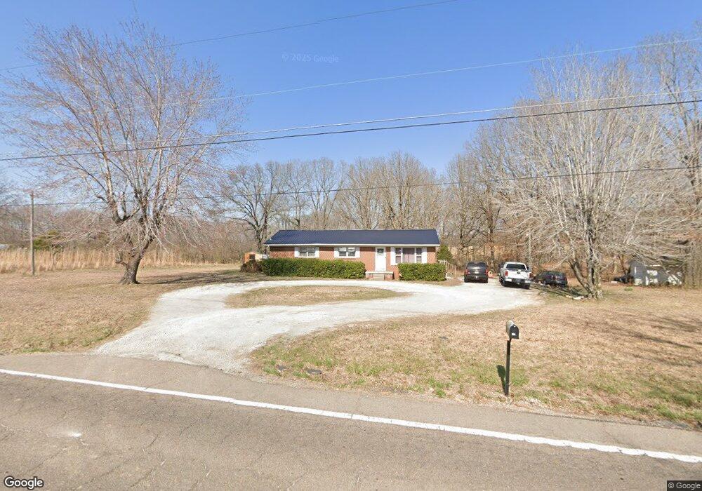
285 Highway 20 Summertown, TN 38483
Estimated Value: $139,308 - $307,000
--
Bed
--
Bath
1,250
Sq Ft
$167/Sq Ft
Est. Value
About This Home
This home is located at 285 Highway 20, Summertown, TN 38483 and is currently estimated at $208,769, approximately $167 per square foot. 285 Highway 20 is a home with nearby schools including Lewis County Elementary School, Lewis County Intermediate School, and Lewis County Middle School.
Ownership History
Date
Name
Owned For
Owner Type
Purchase Details
Closed on
Mar 6, 2012
Sold by
Wayne County Bank
Bought by
Dunivant Jonathan Lane and Dunnivant Heather Elizabeth
Current Estimated Value
Purchase Details
Closed on
Jul 11, 2011
Sold by
Hinson Tracy L
Bought by
Wayne County Bank
Purchase Details
Closed on
Mar 17, 2006
Sold by
Allen Brown Larry
Bought by
Arvil Brown Danny
Purchase Details
Closed on
Oct 3, 2005
Sold by
Arvil Brown Danny
Bought by
Allen Brown Larry
Purchase Details
Closed on
Apr 22, 2004
Sold by
Etal Brown Dorothy Heirs
Bought by
Arvil Brown Danny
Purchase Details
Closed on
Oct 21, 1972
Create a Home Valuation Report for This Property
The Home Valuation Report is an in-depth analysis detailing your home's value as well as a comparison with similar homes in the area
Home Values in the Area
Average Home Value in this Area
Purchase History
| Date | Buyer | Sale Price | Title Company |
|---|---|---|---|
| Dunivant Jonathan Lane | $50,000 | -- | |
| Wayne County Bank | $44,250 | -- | |
| Arvil Brown Danny | $28,332 | -- | |
| Allen Brown Larry | $30,000 | -- | |
| Arvil Brown Danny | -- | -- | |
| -- | -- | -- |
Source: Public Records
Tax History Compared to Growth
Tax History
| Year | Tax Paid | Tax Assessment Tax Assessment Total Assessment is a certain percentage of the fair market value that is determined by local assessors to be the total taxable value of land and additions on the property. | Land | Improvement |
|---|---|---|---|---|
| 2025 | $430 | $39,200 | $0 | $0 |
| 2024 | $430 | $22,825 | $4,225 | $18,600 |
| 2023 | $430 | $22,825 | $4,225 | $18,600 |
| 2022 | $430 | $22,825 | $4,225 | $18,600 |
| 2021 | $430 | $22,825 | $4,225 | $18,600 |
| 2020 | $378 | $22,825 | $4,225 | $18,600 |
| 2019 | $378 | $16,475 | $3,675 | $12,800 |
| 2018 | $378 | $16,475 | $3,675 | $12,800 |
| 2017 | $378 | $16,475 | $3,675 | $12,800 |
| 2016 | $378 | $16,475 | $3,675 | $12,800 |
| 2015 | -- | $16,475 | $3,675 | $12,800 |
| 2014 | -- | $16,475 | $3,675 | $12,800 |
| 2013 | -- | $15,575 | $0 | $0 |
Source: Public Records
Map
Nearby Homes
- 0 Redstone Dr
- 74 Pine Lake Rd
- 0 Pine Lake Rd Unit RTC3012860
- 160 Webb Rd
- 103 Corbin St
- 107 Shady St
- 180 Webb Rd
- 0 Webb Rd
- 1405 Turnpike Rd
- 221 Mckenzie Ln
- 0 Drakes Ln
- 189 Holloway St
- 0 Buffalo Rd Unit RTC3015128
- 206 Daley St
- 412 E College St
- 111 Water Oak Rd
- 306 Drakes Ln
- 3960 Buffalo Rd
- 4835 Summertown Hwy
- 946 Monument Rd
- 1051 Drake Ln
- 283 State Highway 20
- 1049 Drakes Ln
- 1049 Drake Ln
- 1043 Drake Ln
- 269 State Highway 20
- 269 Highway 20
- 260 Highway 20
- 160 Hudgins Ln
- 253 Highway 20
- 117 Hudgins Ln
- 0 Bj's Way Unit 3291848
- 1101 Bj Way S
- 31 Drake Ln
- 166 Hudgins Ln
- 115 Hudgins Ln
- 321 Whispering Oaks St
- 322 Whispering Oaks St
- 242 Highway 20