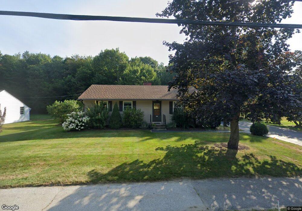
285 South St Concord, NH 03301
South End NeighborhoodEstimated Value: $402,695 - $466,000
3
Beds
2
Baths
1,164
Sq Ft
$379/Sq Ft
Est. Value
About This Home
This home is located at 285 South St, Concord, NH 03301 and is currently estimated at $440,924, approximately $378 per square foot. 285 South St is a home located in Merrimack County with nearby schools including Abbot-Downing School, Rundlett Middle School, and Concord High School.
Ownership History
Date
Name
Owned For
Owner Type
Purchase Details
Closed on
Jun 9, 2025
Sold by
Broadrick Jane
Bought by
Hunt Robert D and Hunt Patricia B
Current Estimated Value
Home Financials for this Owner
Home Financials are based on the most recent Mortgage that was taken out on this home.
Original Mortgage
$328,900
Outstanding Balance
$327,471
Interest Rate
6.76%
Mortgage Type
Credit Line Revolving
Estimated Equity
$113,453
Purchase Details
Closed on
Jul 13, 2012
Sold by
Luckenbach F Bruce F and Luckenbach Norma F
Bought by
Broderick William and Broderick Jane
Purchase Details
Closed on
Mar 1, 2007
Sold by
Joan E Price T
Bought by
Luckenbach F Bruce F and Luckenbach Norma F
Create a Home Valuation Report for This Property
The Home Valuation Report is an in-depth analysis detailing your home's value as well as a comparison with similar homes in the area
Home Values in the Area
Average Home Value in this Area
Purchase History
| Date | Buyer | Sale Price | Title Company |
|---|---|---|---|
| Hunt Robert D | -- | None Available | |
| Hunt Robert D | -- | None Available | |
| Broderick William | $165,000 | -- | |
| Broderick William | $165,000 | -- | |
| Luckenbach F Bruce F | $107,500 | -- | |
| Luckenbach F Bruce F | $107,500 | -- | |
| Luckenbach F Bruce F | $107,500 | -- |
Source: Public Records
Mortgage History
| Date | Status | Borrower | Loan Amount |
|---|---|---|---|
| Open | Hunt Robert D | $328,900 | |
| Closed | Hunt Robert D | $328,900 |
Source: Public Records
Tax History Compared to Growth
Tax History
| Year | Tax Paid | Tax Assessment Tax Assessment Total Assessment is a certain percentage of the fair market value that is determined by local assessors to be the total taxable value of land and additions on the property. | Land | Improvement |
|---|---|---|---|---|
| 2024 | $7,233 | $261,200 | $112,200 | $149,000 |
| 2023 | $7,016 | $261,200 | $112,200 | $149,000 |
| 2022 | $6,762 | $261,200 | $112,200 | $149,000 |
| 2021 | $6,561 | $261,200 | $112,200 | $149,000 |
| 2020 | $6,131 | $229,100 | $89,200 | $139,900 |
| 2019 | $5,628 | $202,600 | $87,400 | $115,200 |
| 2018 | $5,627 | $199,600 | $87,400 | $112,200 |
| 2017 | $5,462 | $193,400 | $87,400 | $106,000 |
| 2016 | $5,163 | $186,600 | $85,800 | $100,800 |
| 2015 | $4,883 | $175,000 | $89,500 | $85,500 |
| 2014 | $4,692 | $175,000 | $89,500 | $85,500 |
| 2013 | -- | $172,900 | $89,500 | $83,400 |
| 2012 | -- | $168,500 | $89,500 | $79,000 |
Source: Public Records
Map
Nearby Homes