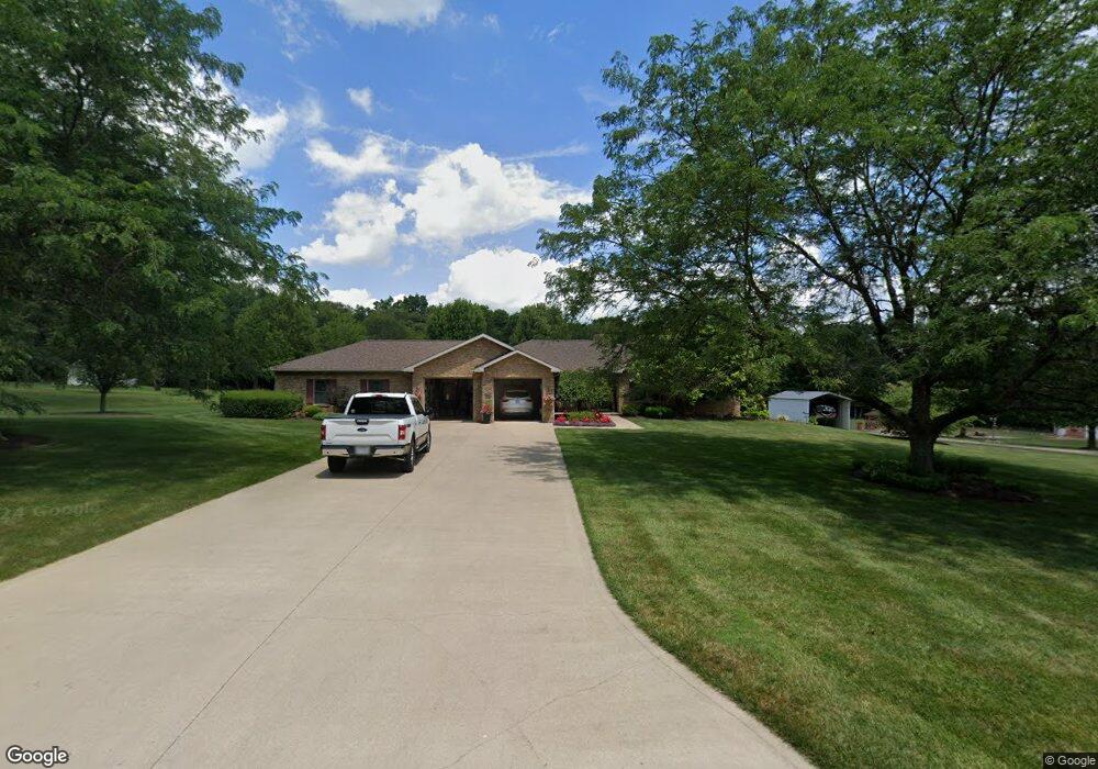
2861 Peterson Rd Mansfield, OH 44903
Estimated Value: $363,000 - $558,000
3
Beds
2
Baths
2,302
Sq Ft
$195/Sq Ft
Est. Value
About This Home
This home is located at 2861 Peterson Rd, Mansfield, OH 44903 and is currently estimated at $449,397, approximately $195 per square foot. 2861 Peterson Rd is a home located in Richland County with nearby schools including Madison High School.
Ownership History
Date
Name
Owned For
Owner Type
Purchase Details
Closed on
Oct 28, 2005
Sold by
Cyrus Gary and Cyrus Linda
Bought by
Cyrus Gary and Cyrus Linda
Current Estimated Value
Purchase Details
Closed on
Jul 6, 1999
Sold by
Tschantz Bruce H
Bought by
Cyrus Gary and Cyrus Linda
Create a Home Valuation Report for This Property
The Home Valuation Report is an in-depth analysis detailing your home's value as well as a comparison with similar homes in the area
Home Values in the Area
Average Home Value in this Area
Purchase History
| Date | Buyer | Sale Price | Title Company |
|---|---|---|---|
| Cyrus Gary | -- | None Available | |
| Cyrus Gary | $18,000 | -- |
Source: Public Records
Tax History Compared to Growth
Tax History
| Year | Tax Paid | Tax Assessment Tax Assessment Total Assessment is a certain percentage of the fair market value that is determined by local assessors to be the total taxable value of land and additions on the property. | Land | Improvement |
|---|---|---|---|---|
| 2024 | $6,323 | $134,860 | $11,660 | $123,200 |
| 2023 | $6,323 | $134,860 | $11,660 | $123,200 |
| 2022 | $4,473 | $90,240 | $9,340 | $80,900 |
| 2021 | $4,471 | $90,240 | $9,340 | $80,900 |
| 2020 | $4,506 | $90,240 | $9,340 | $80,900 |
| 2019 | $3,996 | $76,200 | $7,850 | $68,350 |
| 2018 | $3,962 | $76,200 | $7,850 | $68,350 |
| 2017 | $3,162 | $76,200 | $7,850 | $68,350 |
| 2016 | $3,436 | $66,960 | $7,460 | $59,500 |
| 2015 | $3,381 | $66,960 | $7,460 | $59,500 |
| 2014 | $3,368 | $66,960 | $7,460 | $59,500 |
| 2012 | $1,573 | $68,190 | $7,850 | $60,340 |
Source: Public Records
Map
Nearby Homes
- 2750 Lutz Ave
- 2641 State Route 430
- 0 Peterson Rd
- 609 Mcbride Rd
- 598 Impala Dr
- 0 Satinwood Dr
- 0 McBride Road Parcel # 1 Unit 9066028
- 630 Impala Dr
- 2495 Emma Ln
- 640 Running Brook Way
- 2270 Lakecrest Dr Unit 2272
- 3290 Shad Dr W
- 641 Laver Rd
- 76 Ford Rd N
- 76 Ford Rd N Unit 20
- 0 Mcelroy Rd
- 19 Maine St
- 1910 Crider Rd
- 304 Esley Ln
- 0 State Route 39 & I-71 Northeast Quadrant
- 2879 Peterson Rd
- 2845 Peterson Rd
- 2891 Peterson Rd
- 2842 Peterson Rd
- 2817 Peterson Rd
- 2817 Peterson Rd
- 2832 Peterson Rd
- 2868 Peterson Rd
- 2916 Peterson Rd
- 2795 Peterson Rd
- 2960 Peterson Rd
- 349 Colonial Dr
- 323 Colonial Dr
- 2770 Peterson Rd
- 2751 Peterson Rd
- 2855 Cherokee Dr
- 2758 Peterson Rd
- 346 Colonial Dr
- 300 Colonial Dr
- 2835 Cherokee Dr