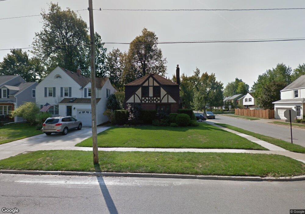
287 Kings Hwy Buffalo, NY 14226
Snyder NeighborhoodEstimated Value: $279,292 - $360,000
3
Beds
2
Baths
1,236
Sq Ft
$261/Sq Ft
Est. Value
About This Home
This home is located at 287 Kings Hwy, Buffalo, NY 14226 and is currently estimated at $322,573, approximately $260 per square foot. 287 Kings Hwy is a home located in Erie County with nearby schools including Smallwood Drive School, Amherst Middle School, and Amherst Central High School.
Ownership History
Date
Name
Owned For
Owner Type
Purchase Details
Closed on
Jul 29, 2011
Sold by
Caterina Salv Atore F
Bought by
Endres Derek J and Endres Rebekah A
Current Estimated Value
Home Financials for this Owner
Home Financials are based on the most recent Mortgage that was taken out on this home.
Original Mortgage
$148,146
Outstanding Balance
$99,139
Interest Rate
4.51%
Mortgage Type
FHA
Estimated Equity
$223,434
Purchase Details
Closed on
Apr 29, 1996
Sold by
Elwood John E and Elwood Julie W
Bought by
Salvatore Caterina
Create a Home Valuation Report for This Property
The Home Valuation Report is an in-depth analysis detailing your home's value as well as a comparison with similar homes in the area
Home Values in the Area
Average Home Value in this Area
Purchase History
| Date | Buyer | Sale Price | Title Company |
|---|---|---|---|
| Endres Derek J | -- | None Available | |
| Salvatore Caterina | $93,000 | -- |
Source: Public Records
Mortgage History
| Date | Status | Borrower | Loan Amount |
|---|---|---|---|
| Open | Endres Derek J | $148,146 |
Source: Public Records
Tax History
| Year | Tax Paid | Tax Assessment Tax Assessment Total Assessment is a certain percentage of the fair market value that is determined by local assessors to be the total taxable value of land and additions on the property. | Land | Improvement |
|---|---|---|---|---|
| 2024 | $5,410 | $240,000 | $37,000 | $203,000 |
| 2023 | $5,149 | $142,000 | $14,500 | $127,500 |
| 2022 | $4,996 | $142,000 | $14,500 | $127,500 |
| 2021 | $4,990 | $142,000 | $14,500 | $127,500 |
| 2020 | $4,243 | $142,000 | $14,500 | $127,500 |
| 2019 | $6,532 | $142,000 | $14,500 | $127,500 |
| 2018 | $3,894 | $142,000 | $14,500 | $127,500 |
| 2017 | $1,687 | $142,000 | $14,500 | $127,500 |
| 2016 | $3,779 | $117,800 | $14,500 | $103,300 |
| 2015 | -- | $117,800 | $14,500 | $103,300 |
| 2014 | -- | $117,800 | $14,500 | $103,300 |
Source: Public Records
Map
Nearby Homes
- 127 Hamilton Dr
- 38 Hancock Terrace
- 280 Roycroft Blvd
- 193 Huxley Dr
- 175 Mount Vernon Rd
- 30 Bentham Pkwy
- 32 Bernhardt Dr Unit 5
- 515 Mount Vernon Rd
- 217 Brantwood Rd
- 266 Merrymont Rd
- 127 Briarcliff Rd
- 485 Darwin Dr
- 75 Liberty Terrace
- 1818 Kensington Ave
- 135 Avalon Dr
- 2 Campwood Ct
- 695 Mount Vernon Rd
- 36 Liberty Terrace
- 505 Lamarck Dr
- 33 Ruskin Rd
- 291 Kings Hwy
- 295 Kings Hwy
- 98 Hamilton Dr
- 277 Kings Hwy
- 102 Hamilton Dr
- 273 Kings Hwy
- 97 Hamilton Dr
- 108 Hamilton Dr
- 269 Kings Hwy
- 288 Kings Hwy
- 233 Bernhardt Dr
- 292 Kings Hwy
- 103 Hamilton Dr
- 237 Bernhardt Dr
- 229 Bernhardt Dr
- 296 Kings Hwy
- 278 Kings Hwy
- 241 Bernhardt Dr
- 112 Hamilton Dr
- 265 Kings Hwy
Your Personal Tour Guide
Ask me questions while you tour the home.