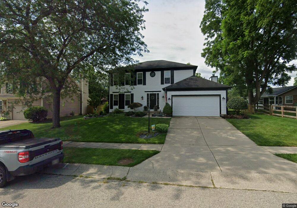
287 Tamarack Trail Springboro, OH 45066
Estimated Value: $353,151 - $380,000
4
Beds
3
Baths
2,038
Sq Ft
$178/Sq Ft
Est. Value
About This Home
This home is located at 287 Tamarack Trail, Springboro, OH 45066 and is currently estimated at $363,538, approximately $178 per square foot. 287 Tamarack Trail is a home located in Warren County with nearby schools including Clearcreek Elementary School, Springboro Intermediate School, and Dennis Elementary School.
Ownership History
Date
Name
Owned For
Owner Type
Purchase Details
Closed on
Aug 25, 1993
Sold by
Clifford Clifford and Clifford Brett J
Bought by
Ruscello Anthony and Ruscello Julie
Current Estimated Value
Purchase Details
Closed on
Nov 27, 1989
Sold by
Ryland Group & Inc
Bought by
Clifford Clifford and Clifford Brett J
Purchase Details
Closed on
Sep 18, 1989
Sold by
Lemon Lemon and Lemon Paul A
Bought by
Ryland Group & Inc
Purchase Details
Closed on
Aug 31, 1989
Sold by
Lemon Lemon and Lemon Paul A
Bought by
Lemon Lemon and Lemon Paul A
Create a Home Valuation Report for This Property
The Home Valuation Report is an in-depth analysis detailing your home's value as well as a comparison with similar homes in the area
Home Values in the Area
Average Home Value in this Area
Purchase History
| Date | Buyer | Sale Price | Title Company |
|---|---|---|---|
| Ruscello Anthony | $152,000 | -- | |
| Clifford Clifford | $128,300 | -- | |
| Ryland Group & Inc | $23,500 | -- | |
| Lemon Lemon | -- | -- |
Source: Public Records
Tax History
| Year | Tax Paid | Tax Assessment Tax Assessment Total Assessment is a certain percentage of the fair market value that is determined by local assessors to be the total taxable value of land and additions on the property. | Land | Improvement |
|---|---|---|---|---|
| 2025 | $3,845 | $98,450 | $29,750 | $68,700 |
| 2024 | $3,845 | $98,450 | $29,750 | $68,700 |
| 2023 | $3,325 | $78,092 | $17,220 | $60,872 |
| 2022 | $3,276 | $78,092 | $17,220 | $60,872 |
| 2021 | $3,049 | $78,092 | $17,220 | $60,872 |
| 2020 | $2,836 | $63,490 | $14,000 | $49,490 |
| 2019 | $2,614 | $63,490 | $14,000 | $49,490 |
| 2018 | $2,616 | $63,490 | $14,000 | $49,490 |
| 2017 | $2,473 | $54,065 | $12,110 | $41,955 |
| 2016 | $2,579 | $54,065 | $12,110 | $41,955 |
| 2015 | $2,551 | $54,065 | $12,110 | $41,955 |
| 2014 | $2,551 | $50,530 | $11,320 | $39,210 |
| 2013 | $2,549 | $62,500 | $14,000 | $48,500 |
Source: Public Records
Map
Nearby Homes
- 350 Spruceway Dr
- 340 Saint James Place
- 245 Whispering Pines St
- 225 Renwood Place
- 23 Pheasant Run Cir Unit 9A
- 1101 Parklake Row
- 4 Chestnut St
- 72 Pebble Brook Place
- 20 Terradyne Trace
- 35 Edgebrooke Dr
- 9680 Williams Dr
- 10 Woods Rd
- 70 Eleanor Dr
- 80 Elkins Ln
- 45 Wadestone St
- 11138 Oakwood Village Blvd
- 15 Wadestone Ln
- 1785 Archerfield Place
- 140 Dan Haven Place
- 90 Libby Hollow St
- 285 Tamarack Trail
- 310 Evergreen Dr
- 300 Evergreen Dr
- 283 Tamarack Trail
- 270 Jeanne Dr
- 286 Tamarack Trail
- 288 Tamarack Trail
- 284 Tamarack Trail
- 260 Jeanne Dr
- 290 Tamarack Trail
- 281 Tamarack Trail
- 315 Evergreen Dr
- 282 Tamarack Trail
- 435 Teakwood Ln
- 305 Tamarack Trail
- 250 Jeanne Dr
- 280 Tamarack Trail
- 410 Evergreen Dr
- 279 Tamarack Trail
- 280 Evergreen Dr
Your Personal Tour Guide
Ask me questions while you tour the home.