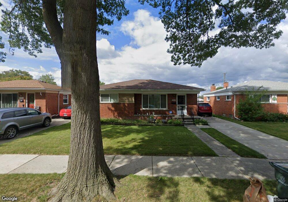
28713 Joan St Saint Clair Shores, MI 48081
Estimated Value: $229,499 - $258,000
3
Beds
2
Baths
1,100
Sq Ft
$221/Sq Ft
Est. Value
About This Home
This home is located at 28713 Joan St, Saint Clair Shores, MI 48081 and is currently estimated at $242,875, approximately $220 per square foot. 28713 Joan St is a home located in Macomb County with nearby schools including Rodgers Elementary School, Kennedy Middle School, and Lake Shore High School.
Ownership History
Date
Name
Owned For
Owner Type
Purchase Details
Closed on
Mar 6, 2023
Sold by
Lucido Joseph H
Bought by
Lucido Joseph H
Current Estimated Value
Purchase Details
Closed on
Sep 19, 2011
Sold by
Lucido Joseph H
Bought by
Lucido Joseph M and Grillo Debra
Purchase Details
Closed on
May 16, 2011
Sold by
Lasalle Bank National Association
Bought by
Northeast Property Holdings Llc
Purchase Details
Closed on
Dec 1, 2010
Sold by
Financial Freedom Acquisition Llc
Bought by
Lasalle Bank National Association
Purchase Details
Closed on
Nov 19, 2010
Sold by
Cutter Allen Richard
Bought by
Financial Freedom Acquisition Llc
Create a Home Valuation Report for This Property
The Home Valuation Report is an in-depth analysis detailing your home's value as well as a comparison with similar homes in the area
Home Values in the Area
Average Home Value in this Area
Purchase History
| Date | Buyer | Sale Price | Title Company |
|---|---|---|---|
| Lucido Joseph H | -- | -- | |
| Lucido Joseph M | -- | Colonial Title Company | |
| Lucido Joseph H | $82,000 | Colonial Title Company | |
| Northeast Property Holdings Llc | $45,000 | Attorneys Title Agency Llc | |
| Lasalle Bank National Association | -- | None Available | |
| Financial Freedom Acquisition Llc | $85,000 | None Available |
Source: Public Records
Tax History Compared to Growth
Tax History
| Year | Tax Paid | Tax Assessment Tax Assessment Total Assessment is a certain percentage of the fair market value that is determined by local assessors to be the total taxable value of land and additions on the property. | Land | Improvement |
|---|---|---|---|---|
| 2025 | $2,632 | $104,100 | $0 | $0 |
| 2024 | $2,632 | $103,700 | $0 | $0 |
| 2023 | $2,502 | $91,000 | $0 | $0 |
| 2022 | $2,372 | $82,800 | $0 | $0 |
| 2021 | $2,329 | $78,800 | $0 | $0 |
| 2020 | $2,338 | $74,200 | $0 | $0 |
| 2019 | $2,222 | $68,400 | $0 | $0 |
| 2018 | $2,186 | $63,000 | $0 | $0 |
| 2017 | $2,105 | $59,900 | $7,500 | $52,400 |
| 2016 | $1,955 | $59,900 | $0 | $0 |
| 2015 | $1,907 | $53,400 | $0 | $0 |
| 2012 | -- | $44,900 | $6,800 | $38,100 |
Source: Public Records
Map
Nearby Homes
- 28824 Boston St
- 28813 Beste St
- 28906 Hughes St
- 19791 Martin Rd Unit 11
- 28710 Little MacK Ave
- 29243 Boston St
- 28930 Little MacK Ave
- 20101 Meier Rd
- 28131 Elmdale St
- 20918 Michael Ct
- 28316 Little MacK Ave
- 20924 Saint Gertrude St
- 28107 Ursuline St
- 28413 Ruehle St
- 29075 Congress St
- 19396 Wilfred St
- 28113 Shock St
- 19343 Florence St
- 19308 Florence St
- 19423 Hazelwood St