Estimated Value: $374,000 - $435,000
4
Beds
2
Baths
2,602
Sq Ft
$154/Sq Ft
Est. Value
About This Home
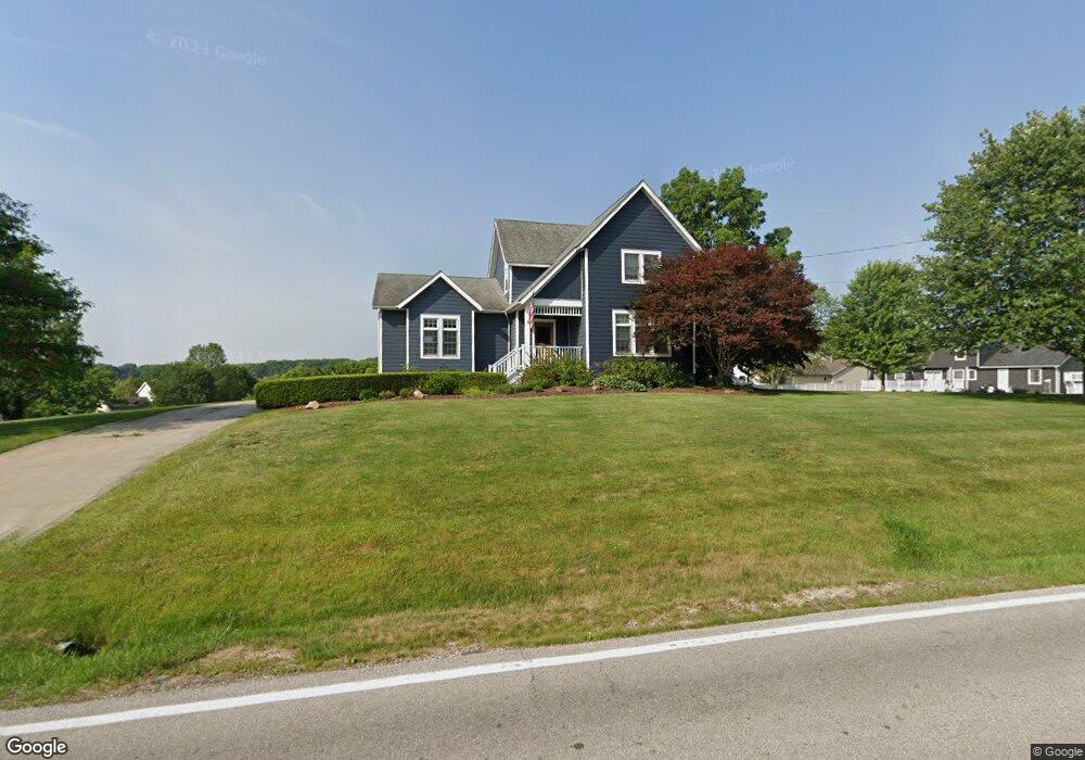
This home is located at 2878 Norton Rd, Stow, OH 44224 and is currently estimated at $400,209, approximately $153 per square foot. 2878 Norton Rd is a home located in Summit County with nearby schools including Stow-Munroe Falls High School, Primrose School of Hudson, and Seton Catholic Elementary School.
Ownership History
Date
Name
Owned For
Owner Type
Purchase Details
Closed on
Nov 18, 2001
Sold by
Jaffray Daniel D and Jaffray Traci J
Bought by
Jaffray Daniel D and Jaffray Traci J
Current Estimated Value
Purchase Details
Closed on
Mar 19, 1997
Sold by
Dornetta Elizabeth L
Bought by
Jaffray Daniel D and Jaffray Traci J
Home Financials for this Owner
Home Financials are based on the most recent Mortgage that was taken out on this home.
Original Mortgage
$149,000
Outstanding Balance
$18,197
Interest Rate
7.82%
Mortgage Type
New Conventional
Estimated Equity
$382,012
Create a Home Valuation Report for This Property
The Home Valuation Report is an in-depth analysis detailing your home's value as well as a comparison with similar homes in the area
Home Values in the Area
Average Home Value in this Area
Purchase History
| Date | Buyer | Sale Price | Title Company |
|---|---|---|---|
| Jaffray Daniel D | -- | Endress/Lawyers Title | |
| Jaffray Daniel D | -- | Endress/Lawyers Title | |
| Jaffray Daniel D | $145,000 | -- |
Source: Public Records
Mortgage History
| Date | Status | Borrower | Loan Amount |
|---|---|---|---|
| Open | Jaffray Daniel D | $149,000 |
Source: Public Records
Tax History
| Year | Tax Paid | Tax Assessment Tax Assessment Total Assessment is a certain percentage of the fair market value that is determined by local assessors to be the total taxable value of land and additions on the property. | Land | Improvement |
|---|---|---|---|---|
| 2024 | $5,844 | $98,042 | $21,224 | $76,818 |
| 2023 | $5,844 | $98,042 | $21,224 | $76,818 |
| 2022 | $5,879 | $77,596 | $16,454 | $61,142 |
| 2021 | $4,640 | $77,596 | $16,454 | $61,142 |
| 2020 | $4,406 | $73,060 | $16,450 | $56,610 |
| 2019 | $4,292 | $66,440 | $26,130 | $40,310 |
| 2018 | $4,227 | $66,440 | $26,130 | $40,310 |
| 2017 | $3,777 | $66,440 | $26,130 | $40,310 |
| 2016 | $3,880 | $58,040 | $26,130 | $31,910 |
| 2015 | $3,777 | $58,040 | $26,130 | $31,910 |
| 2014 | $3,780 | $58,040 | $26,130 | $31,910 |
| 2013 | $3,756 | $58,030 | $26,130 | $31,900 |
Source: Public Records
Map
Nearby Homes
- 5361 Diana Lynn Dr
- 76 Wanda Ct
- 4916 Friar Rd Unit B
- 1995 Weston Dr
- 2221 Crockett Cir
- 2908 Wexford Blvd
- V/L Norton Rd
- 4909 Fishcreek Rd
- 2188 Duxbury
- 4556 Fishcreek Rd
- 5091 Ridge Meadow Dr
- 4399-4403 Cherryhurst Dr
- 2353 W Hale Dr
- 2279 Becket Cir
- 1620 Sapphire Dr
- 5123 Sodalite Dr
- 131 Wanda Ct
- 4704 Red Willow Rd
- 6372 Hardwick Cir
- 2365 Norman Dr
- 5303 Camden Dr
- 5315 Camden Dr
- 5295 Camden Dr
- 2888 Norton Rd
- 5287 Camden Dr
- 5272 Brockton Dr
- 3151 Ravineview Cir
- 5279 Camden Dr
- 55 Judson Rd
- 5267 Brockton Dr
- 5264 Brockton Dr
- 3141 Ravineview Cir
- 5306 Camden Dr
- 60 Judson Rd
- 5271 Camden Dr
- 5294 Camden Dr
- 5318 Camden Dr
- 5280 Camden Dr
- 3112 Ravineview Cir
- 5255 Brockton Dr
Your Personal Tour Guide
Ask me questions while you tour the home.