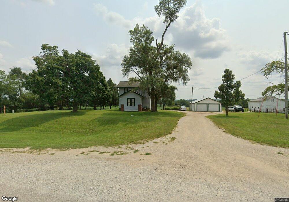
2884 State Highway 92 Winterset, IA 50273
Estimated Value: $146,000 - $416,000
3
Beds
1
Bath
1,288
Sq Ft
$188/Sq Ft
Est. Value
About This Home
This home is located at 2884 State Highway 92, Winterset, IA 50273 and is currently estimated at $242,247, approximately $188 per square foot. 2884 State Highway 92 is a home located in Madison County with nearby schools including Winterset Elementary School, Winterset Middle School, and Winterset Junior High School.
Ownership History
Date
Name
Owned For
Owner Type
Purchase Details
Closed on
Feb 18, 2022
Sold by
Paul Dyer Ronald and Paul Heather
Bought by
Dyer Ronald Paul and Dyer Heather
Current Estimated Value
Home Financials for this Owner
Home Financials are based on the most recent Mortgage that was taken out on this home.
Original Mortgage
$92,800
Outstanding Balance
$80,478
Interest Rate
3.69%
Mortgage Type
New Conventional
Estimated Equity
$161,769
Purchase Details
Closed on
Jul 31, 2018
Sold by
Ross Kimbra D
Bought by
Dyer Ronald P
Home Financials for this Owner
Home Financials are based on the most recent Mortgage that was taken out on this home.
Original Mortgage
$90,033
Interest Rate
4.7%
Mortgage Type
FHA
Create a Home Valuation Report for This Property
The Home Valuation Report is an in-depth analysis detailing your home's value as well as a comparison with similar homes in the area
Home Values in the Area
Average Home Value in this Area
Purchase History
| Date | Buyer | Sale Price | Title Company |
|---|---|---|---|
| Dyer Ronald Paul | -- | Dec Frank P | |
| Dyer Ronald Paul | -- | None Listed On Document | |
| Dyer Ronald P | $84,000 | -- |
Source: Public Records
Mortgage History
| Date | Status | Borrower | Loan Amount |
|---|---|---|---|
| Open | Dyer Ronald Paul | $92,800 | |
| Closed | Dyer Ronald Paul | $92,800 | |
| Previous Owner | Dyer Ronald P | $90,033 |
Source: Public Records
Tax History Compared to Growth
Tax History
| Year | Tax Paid | Tax Assessment Tax Assessment Total Assessment is a certain percentage of the fair market value that is determined by local assessors to be the total taxable value of land and additions on the property. | Land | Improvement |
|---|---|---|---|---|
| 2025 | $1,760 | $160,600 | $76,200 | $84,400 |
| 2024 | $1,752 | $137,900 | $61,100 | $76,800 |
| 2023 | $1,782 | $137,900 | $61,100 | $76,800 |
| 2022 | $1,882 | $116,700 | $61,100 | $55,600 |
| 2021 | $1,882 | $116,700 | $61,100 | $55,600 |
| 2020 | $1,606 | $92,300 | $44,200 | $48,100 |
| 2019 | $1,552 | $86,200 | $0 | $0 |
| 2018 | $1,524 | $86,200 | $0 | $0 |
| 2017 | $1,496 | $82,900 | $0 | $0 |
| 2016 | $1,272 | $82,900 | $0 | $0 |
| 2015 | $1,170 | $78,000 | $0 | $0 |
| 2014 | $1,172 | $78,000 | $0 | $0 |
Source: Public Records
Map
Nearby Homes
- 701 North St
- 531 Long St
- 150 S 4th St
- 1930 Upland Trail
- Highway 92
- St Charles Rd
- 2337 Vintage Ln
- 2368 Saint Charles Rd
- 001 Saint Charles Rd
- 000 Saint Charles Rd
- TBD Pioneer Ave
- 2366 Holliwell Bridge Rd
- 1706 Mueller Ct
- 1694 McBride Ridge Ct
- 2352 Bevington Park Rd
- 3395 218th St
- 2571 250th Ln
- 2228 Holliwell Valley Ct
- 13316 13th Ave
- 2560 Timber Ln
- 2884 State Highway 92
- 2860 State Highway 92
- 2907 State Highway 92
- 2837 State Highway 92
- 2844 State Highway 92
- 680 North St
- 651 Long St
- 507 North St
- 750 Long St
- 2858 201st Trail
- 501 North St
- 2911 200th Trail
- 690 Long St
- 100 N 6th St
- 2886 201st Trail
- 591 Long St
- 0.75 Acres North St
- 130 S 6th St
- 170 N 5th St
- 471 North St