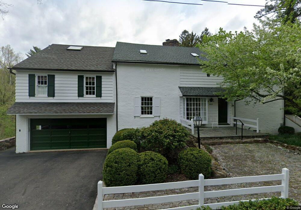
2885 Mill Rd Doylestown, PA 18902
Estimated Value: $1,058,000 - $1,654,000
5
Beds
3
Baths
3,014
Sq Ft
$424/Sq Ft
Est. Value
About This Home
This home is located at 2885 Mill Rd, Doylestown, PA 18902 and is currently estimated at $1,277,704, approximately $423 per square foot. 2885 Mill Rd is a home located in Bucks County with nearby schools including Buckingham Elementary School, Holicong Middle School, and Central Bucks High School - East.
Ownership History
Date
Name
Owned For
Owner Type
Purchase Details
Closed on
May 10, 2016
Sold by
Mcleod Margaret L
Bought by
Mcleod Brian R and Mcleod Margaret L
Current Estimated Value
Purchase Details
Closed on
Sep 10, 2004
Sold by
Mcleod Brian R and Mcleod Margaret L
Bought by
Mcleod Margaret L
Purchase Details
Closed on
Feb 14, 1997
Sold by
Wannemacher James R and Wannemacher Kathryn R
Bought by
Mcleod Brian R and Mcleod Margaret L
Home Financials for this Owner
Home Financials are based on the most recent Mortgage that was taken out on this home.
Original Mortgage
$200,000
Outstanding Balance
$23,101
Interest Rate
7.8%
Estimated Equity
$1,254,603
Create a Home Valuation Report for This Property
The Home Valuation Report is an in-depth analysis detailing your home's value as well as a comparison with similar homes in the area
Home Values in the Area
Average Home Value in this Area
Purchase History
| Date | Buyer | Sale Price | Title Company |
|---|---|---|---|
| Mcleod Brian R | -- | Attorney | |
| Mcleod Margaret L | -- | -- | |
| Mcleod Brian R | $470,000 | T A Title Insurance Company |
Source: Public Records
Mortgage History
| Date | Status | Borrower | Loan Amount |
|---|---|---|---|
| Open | Mcleod Brian R | $200,000 |
Source: Public Records
Tax History
| Year | Tax Paid | Tax Assessment Tax Assessment Total Assessment is a certain percentage of the fair market value that is determined by local assessors to be the total taxable value of land and additions on the property. | Land | Improvement |
|---|---|---|---|---|
| 2025 | $11,273 | $69,240 | $21,240 | $48,000 |
| 2024 | $11,273 | $69,240 | $21,240 | $48,000 |
| 2023 | $10,891 | $69,240 | $21,240 | $48,000 |
| 2022 | $10,761 | $69,240 | $21,240 | $48,000 |
| 2021 | $10,632 | $69,240 | $21,240 | $48,000 |
| 2020 | $10,632 | $69,240 | $21,240 | $48,000 |
| 2019 | $10,563 | $69,240 | $21,240 | $48,000 |
| 2018 | $10,563 | $69,240 | $21,240 | $48,000 |
| 2017 | $10,476 | $69,240 | $21,240 | $48,000 |
| 2016 | $10,580 | $69,240 | $21,240 | $48,000 |
| 2015 | -- | $69,240 | $21,240 | $48,000 |
| 2014 | -- | $69,240 | $21,240 | $48,000 |
Source: Public Records
Map
Nearby Homes
- 2918 Snake Hill Rd
- 3889 Robin Rd
- 2980 Yorkshire Rd
- 3775 Buckingham Dr
- 3795 Route 202
- 4602 Sands Way
- 2798 Forge Place
- 117 Windover Ln
- 4203 Greenspire Ln
- 3660 Buttonwood Dr
- 3039 Durham Rd
- 34 Houk Rd
- 3455 & 3479 Durham Rd
- 000 Cherry Ln
- 45 Springs Dr
- 45 Creek Dr
- 106 Saddle Dr
- 5025 Anderson Rd
- 150 Watercrest Dr
- 2209 Swamp Rd
- 2898 Mill Rd
- 2881 Furlong Rd
- 2867 Mill Rd
- 2890 Furlong Rd
- 4078 Spring Valley Rd
- 2869 Furlong Rd
- 2918 Mill Rd
- 2835 Mill Rd
- 2866 Furlong Rd
- 4128 Route 202
- 4143 E State St
- 4097 Mill Rd
- 4106 Route 202 Unit 1
- 4120 Route 202
- 4120 Route 202 Unit 202
- 4106 U S 202 Unit D
- 2852 Furlong Rd
- 2920 Valley View Dr
- 4087 Route 202 Unit B
- 4087 Route 202 Unit 1
Your Personal Tour Guide
Ask me questions while you tour the home.